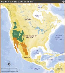
NORTH AMERICAN DESERT MAP

NORTH AMERICAN DESERT MAP
Map of North American deserts shows the major desert regions spanning the United States and Mexico. This map distinguishes between hot deserts such as the Sonoran, Mojave, and Chihuahuan, and cold deserts such as the Great Basin. These deserts differ in climate, biodiversity, and geography, shaping unique ecosystems. Hot deserts, located primarily in the southwestern United States and northern Mexico, are characterized by dry conditions and high temperatures. Cold deserts, found at higher elevations, have colder winters and more rainfall. This map provides an informative geographic overview of the desert landscapes that shape North America's natural environment.