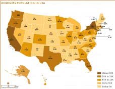
MAP OF UNITED STATES

The Map of the United States provides a comprehensive view of the country's geography, major cities, transportation routes, and major landmarks. It highlights the 50 states, their boundaries, state capitals, and major urban centers such as New York City, Los Angeles, Chicago, and the nation's capital, Washington, D.C. The map also features detailed depictions of the extensive network of highways, interstates, and roads that connect the country, making it an excellent resource for travelers and geography enthusiasts.
This is a detailed political map of the United States, displaying all 50 states, their capitals, major cities, and major geographic features. The map includes state boundaries, major highways, national parks, and mountain peaks. It also shows nearby countries such as Canada and Mexico, as well as nearby water bodies such as the Pacific Ocean, Atlantic Ocean, and Gulf of Mexico.
In addition to the mainland, the map includes insets for Alaska and Hawaii, which offer a complete view of the United States. The vast wilderness of Alaska and the islands of Hawaii are presented in detail, emphasizing the unique geographic and cultural diversity of these regions. The map also depicts nearby countries such as Canada and Mexico, as well as major water bodies such as the Atlantic and Pacific Oceans and the Gulf of Mexico.
This map serves as an educational tool for understanding the layout of the United States, its natural resources, and its infrastructure. Whether for educational use, travel planning, or general interest, this visual representation provides valuable information about the country's physical and political make-up. It is a versatile resource for anyone interested in exploring the United States in detail.
Frequently Asked Questions about the United States
1. What is the capital of the United States?
The capital of the United States is Washington, D.C., located along the Potomac River between Maryland and Virginia. It serves as the nation's political and administrative center.
2. How many states are there in the USA?
The United States consists of 50 states, including 48 contiguous states and two non-contiguous states — Alaska and Hawaii.
3. What is the population of the United States?
As of 2025, the United States has an estimated population of around 335 million people, making it the third most populous country in the world.
4. What is the currency of the United States?
The official currency of the United States is the U.S. Dollar (USD), symbolized as $. It is one of the most widely used currencies worldwide.
5. What are the major geographical features of the United States?
The U.S. features diverse landscapes including the Rocky Mountains, Appalachian Mountains, Great Plains, Mississippi River, Great Lakes, and coastlines along both the Atlantic and Pacific Oceans.
6. When was the United States established or gained independence?
The United States declared independence from Great Britain on July 4, 1776.


- Alabama
- Alaska
- Arizona
- Arkansas
- California
- Colorado
- Connecticut
- Delaware
- Florida
- Georgia
- Hawaii
- Idaho
- Illinois
- Indiana
- Iowa
- Kansas
- Kentucky
- Louisiana
- Maine
- Maryland
- Massachusetts
- Michigan
- Minnesota
- Mississippi
- Missouri
- Montana
- Nebraska
- Nevada
- New Hampshire
- New Jersey
- New Mexico
- New York
- North Carolina
- North Dakota
- Ohio
- Oklahoma
- Oregon
- Pennsylvania
- Rhode Island
- South Carolina
- South Dakota
- Tennessee
- Texas
- Utah
- Vermont
- Virginia
- Washington
- West Virginia
- Wisconsin
- Wyoming
- District of Columbia (Federal district)
- Afghanistan
- Albania
- Algeria
- Andorra
- Angola
- Antigua and Barbuda
- Argentina
- Armenia
- Australia
- Austria
- Azerbaijan
- Bahrain
- Bangladesh
- Barbados
- Belarus
- Belgium
- Belize
- Benin
- Bhutan
- Bolivia
- Bosnia and Herzegovina
- Botswana
- Brazil
- Brunei
- Bulgaria
- Burkina Faso
- Burma (Myanmar)
- Burundi
- Cabo Verde
- Cambodia
- Cameroon
- Canada
- Central African Republic
- Chad
- Chile
- China
- Colombia
- Comoros Islands
- Democratic Republic of the Congo
- Costa Rica
- Cote d'Ivoire
- Croatia
- Cuba
- Cyprus
- Czechia
- Denmark
- Djibouti
- Dominica
- Dominican Republic
- Ecuador
- Egypt
- El Salvador
- England
- Equatorial Guinea
- Eritrea
- Estonia
- eSwatini (formerly Swaziland)
- Ethiopia
- Federated States of Micronesia
- Fiji
- Finland
- France
- Gabon
- The Gambia
- Georgia
- Germany
- Ghana
- Greece
- Grenada
- Guatemala
- Guinea
- Guinea-Bissau
- Guyana
- Haiti
- Holy See
- Honduras
- Hungary
- Iceland
- India
- Indonesia
- Iran
- Iraq
- Ireland
- Israel
- Italy
- Jamaica
- Japan
- Jordan
- Kazakhstan
- Kenya
- Kiribati
- Kosovo
- Kuwait
- Kyrgyzstan
- Laos
- Latvia
- Lebanon
- Lesotho
- Liberia
- Libya
- Liechtenstein
- Lithuania
- Luxembourg
- Madagascar
- Malawi
- Malaysia
- Maldives
- Mali
- Malta
- Marshall Islands
- Mauritania
- Mauritius
- Mexico
- Moldova
- Monaco
- Mongolia
- Montenegro
- Morocco
- Mozambique
- Namibia
- Nauru
- Nepal
- Netherlands
- New Zealand
- Nicaragua
- Niger
- Nigeria
- North Korea
- Northern Ireland
- Norway
- Oman
- Pakistan
- Palau
- Panama
- Papua New Guinea
- Paraguay
- Peru
- Philippines
- Poland
- Portugal
- Puerto Rico (USA)
- Qatar
- North Macedonia
- Romania
- Russia
- Rwanda
- Saint Kitts and Nevis
- Saint Lucia
- Saint Vincent & the Grenadines
- Samoa
- San Marino
- Sao Tome and Principe
- Saudi Arabia
- Scotland
- Senegal
- Serbia
- Seychelles
- Sierra Leone
- Singapore
- Slovakia
- Slovenia
- Solomon Islands
- Somalia
- South Africa
- South Korea
- South Sudan
- Spain
- Sri Lanka
- Sudan
- Suriname
- Sweden
- Switzerland
- Syria
- Tajikistan
- Taiwan
- Tanzania
- Thailand
- The Bahamas
- Timor-Leste
- Togo
- Tonga
- Trinidad and Tobago
- Tunisia
- Turkey
- Turkmenistan
- Tuvalu
- Uganda
- Ukraine
- United Arab Emirates
- United Kingdom
- United States of America
- Uruguay
- Uzbekistan
- Vanuatu
- Western Sahara
- Venezuela
- Vietnam
- Wales
- Yemen
- Zambia
- Zimbabwe
