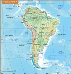
SOUTH AMERICA PHYSICAL MAP

About South America Physical Map
This South America physical map highlights the continent’s diverse natural landscapes and elevation patterns. It displays the Andes Mountains, Amazon Basin, Brazilian Highlands, Guiana Highlands, Patagonian Plateau, major rivers, lakes, deserts, forests, and surrounding oceans. Color gradients illustrate altitude variations, helping users understand terrain differences from coastal plains to high mountain ranges. The map is ideal for education, research, travel planning, and classroom presentations. Clear labeling improves geographic awareness of countries, boundaries, and key physical features. Students, teachers, and cartography enthusiasts can explore drainage systems, climate-influenced regions, and tectonic formations. Use this map to visualize South America’s remarkable physical geography.