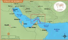
Strait of Hormuz Map

About Strait of Hormuz Map
This map illustrates the strategic location of the Strait of Hormuz, a narrow waterway connecting the Persian Gulf with the Gulf of Oman and the Arabian Sea. The map highlights nearby countries including Iran, Oman, the United Arab Emirates, Saudi Arabia, Kuwait, and Qatar, along with major cities such as Dubai, Abu Dhabi, Muscat, and Bandar Abbas. The Strait of Hormuz is one of the world’s most important maritime chokepoints, as a large portion of global oil shipments pass through this route daily. By showing surrounding geography, coastal cities, and nearby seas, this map helps viewers understand the geopolitical and economic significance of this critical international shipping corridor.