Gujarat District Map

About Gujarat District Map
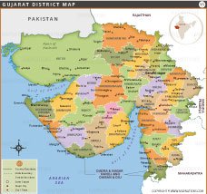
This detailed Gujarat district map displays all 33 districts in the state with their names, boundaries, major cities, and the state capital. The map shows large districts like Kutch, which is the largest in Gujarat and India by area, and smaller districts like Dangs, which are known for their tribal population and forests. Districts are color-coded for easy identification, and important cities like Ahmedabad, Surat, Vadodara, and Rajkot are clearly marked. The map also includes the location of Dadra and Nagar Haveli and Daman and Diu and the borders with neighboring states—Rajasthan, Madhya Pradesh, and Maharashtra. The coastal areas of the Arabian Sea and Gulf of Khambhat are outlined. This map is ideal for geography education, planning, and travel reference.
List of Districts in Gujarat
| District | Headquarters | Area(km.²) | Population | Amreli | Amreli | 6760 | 1514190 | Anand | Anand | 2942 | 2092745 | Banas Kantha | Banas Kantha | 12703 | 3120506 | Bharuch | Bharuch | 6524 | 1551019 | Bhavnagar | Bhavnagar | 11155 | 2880365 | Dahod | Dahod | 3642 | 2127086 | Gandhinagar | Gandhinagar | 649 | 1391753 | Jamnagar | Jamnagar | 14125 | 2160119 | Junagadh | Junagadh | 8839 | 2743082 | Kachchh | Bhuj | 45652 | 2092371 | Kheda | Kheda | 4215 | 2299885 | Mahesana | Mahesana | 4386 | 2035064 | Narmada | Rajpipla | 2749 | 590297 | Navsari | Navsari | 2211 | 1329672 | Panch Mahals | Panch Mahals | 5219 | 2390776 | Patan | Patan | 5738 | 1343734 | Porbandar | Porbandar | 2294 | 585449 | Rajkot | Rajkot | 11203 | 3804558 | Sabar Kantha | Sabar Kantha | 7390 | 2428589 | Surat | Surat | 7657 | 6081322 | Surendranagar | Surendranagar | 10489 | 1756268 | Tapi | Surat | 7657 | 807022 | The Dangs | Ahwa | 1764 | 228291 | Vadodara | Vadodara | 7794 | 4165626 | Valsad | Valsad | 3034 | 1705678 |
|---|


- Afghanistan
- Albania
- Algeria
- Andorra
- Angola
- Antigua and Barbuda
- Argentina
- Armenia
- Australia
- Austria
- Azerbaijan
- Bahrain
- Bangladesh
- Barbados
- Belarus
- Belgium
- Belize
- Benin
- Bhutan
- Bolivia
- Bosnia and Herzegovina
- Botswana
- Brazil
- Brunei
- Bulgaria
- Burkina Faso
- Burma (Myanmar)
- Burundi
- Cabo Verde
- Cambodia
- Cameroon
- Canada
- Central African Republic
- Chad
- Chile
- China
- Colombia
- Comoros Islands
- Democratic Republic of the Congo
- Costa Rica
- Cote d'Ivoire
- Croatia
- Cuba
- Cyprus
- Czechia
- Denmark
- Djibouti
- Dominica
- Dominican Republic
- Ecuador
- Egypt
- El Salvador
- England
- Equatorial Guinea
- Eritrea
- Estonia
- eSwatini (formerly Swaziland)
- Ethiopia
- Federated States of Micronesia
- Fiji
- Finland
- France
- Gabon
- The Gambia
- Georgia
- Germany
- Ghana
- Greece
- Grenada
- Guatemala
- Guinea
- Guinea-Bissau
- Guyana
- Haiti
- Holy See
- Honduras
- Hungary
- Iceland
- India
- Indonesia
- Iran
- Iraq
- Ireland
- Israel
- Italy
- Jamaica
- Japan
- Jordan
- Kazakhstan
- Kenya
- Kiribati
- Kosovo
- Kuwait
- Kyrgyzstan
- Laos
- Latvia
- Lebanon
- Lesotho
- Liberia
- Libya
- Liechtenstein
- Lithuania
- Luxembourg
- Madagascar
- Malawi
- Malaysia
- Maldives
- Mali
- Malta
- Marshall Islands
- Mauritania
- Mauritius
- Mexico
- Moldova
- Monaco
- Mongolia
- Montenegro
- Morocco
- Mozambique
- Namibia
- Nauru
- Nepal
- Netherlands
- New Zealand
- Nicaragua
- Niger
- Nigeria
- North Korea
- Northern Ireland
- Norway
- Oman
- Pakistan
- Palau
- Panama
- Papua New Guinea
- Paraguay
- Peru
- Philippines
- Poland
- Portugal
- Puerto Rico (USA)
- Qatar
- North Macedonia
- Romania
- Russia
- Rwanda
- Saint Kitts and Nevis
- Saint Lucia
- Saint Vincent & the Grenadines
- Samoa
- San Marino
- Sao Tome and Principe
- Saudi Arabia
- Scotland
- Senegal
- Serbia
- Seychelles
- Sierra Leone
- Singapore
- Slovakia
- Slovenia
- Solomon Islands
- Somalia
- South Africa
- South Korea
- South Sudan
- Spain
- Sri Lanka
- Sudan
- Suriname
- Sweden
- Switzerland
- Syria
- Tajikistan
- Taiwan
- Tanzania
- Thailand
- The Bahamas
- Timor-Leste
- Togo
- Tonga
- Trinidad and Tobago
- Tunisia
- Turkey
- Turkmenistan
- Tuvalu
- Uganda
- Ukraine
- United Arab Emirates
- United Kingdom
- United States of America
- Uruguay
- Uzbekistan
- Vanuatu
- Western Sahara
- Venezuela
- Vietnam
- Wales
- Yemen
- Zambia
- Zimbabwe
