NAMIBIA MAP

About Namibia Map
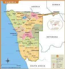
Map of Namibia highlights the country’s regional divisions, major cities, and transportation network. It shows Namibia’s boundaries with Angola, Zambia, Botswana, and South Africa, along with its key regions such as Khomas, Erongo, Hardap, and Kavango East and West. The map marks the capital city, Windhoek, as well as important towns like Swakopmund, Rundu, Keetmanshoop, and Lüderitz. Major roads, rivers including the Zambezi, and prominent landmarks such as Etosha National Park are also depicted. Ideal for educational, reference, and travel purposes, this Namibia map provides a clear overview of the country’s geography and administrative layout.
Frequently Asked Questions about the Namibia
1. What is the capital city of Namibia?
The capital and largest city of Namibia is Windhoek, located in the central part of the country.
2. Where is Namibia located?
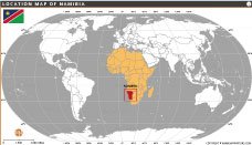
Namibia is located in southwestern Africa. It shares borders with Angola, Zambia, Botswana, and South Africa, with the Atlantic Ocean to the west.
3. What is Namibia famous for?
Namibia is famous for the Namib Desert, Etosha National Park, wildlife safaris, sand dunes at Sossusvlei, and the Skeleton Coast.
4. What is the official language of Namibia?
English is the official language of Namibia. Other commonly spoken languages include Afrikaans, German, Oshiwambo, and Herero.
5. What currency is used in Namibia?
Namibia uses the Namibian Dollar (NAD). The South African Rand is also accepted throughout the country.
6. What is the population of Namibia?
Namibia has a population of around 3 million people, making it one of the least densely populated countries in the world.
7. What is the best time to visit Namibia?
The best time to visit Namibia is during the dry season from May to October, when wildlife viewing and desert travel conditions are ideal.
- Afghanistan
- Albania
- Algeria
- Andorra
- Angola
- Antigua and Barbuda
- Argentina
- Armenia
- Australia
- Austria
- Azerbaijan
- Bahrain
- Bangladesh
- Barbados
- Belarus
- Belgium
- Belize
- Benin
- Bhutan
- Bolivia
- Bosnia and Herzegovina
- Botswana
- Brazil
- Brunei
- Bulgaria
- Burkina Faso
- Burma (Myanmar)
- Burundi
- Cabo Verde
- Cambodia
- Cameroon
- Canada
- Central African Republic
- Chad
- Chile
- China
- Colombia
- Comoros Islands
- Democratic Republic of the Congo
- Costa Rica
- Cote d'Ivoire
- Croatia
- Cuba
- Cyprus
- Czechia
- Denmark
- Djibouti
- Dominica
- Dominican Republic
- Ecuador
- Egypt
- El Salvador
- England
- Equatorial Guinea
- Eritrea
- Estonia
- eSwatini (formerly Swaziland)
- Ethiopia
- Federated States of Micronesia
- Fiji
- Finland
- France
- Gabon
- The Gambia
- Georgia
- Germany
- Ghana
- Greece
- Grenada
- Guatemala
- Guinea
- Guinea-Bissau
- Guyana
- Haiti
- Holy See
- Honduras
- Hungary
- Iceland
- India
- Indonesia
- Iran
- Iraq
- Ireland
- Israel
- Italy
- Jamaica
- Japan
- Jordan
- Kazakhstan
- Kenya
- Kiribati
- Kosovo
- Kuwait
- Kyrgyzstan
- Laos
- Latvia
- Lebanon
- Lesotho
- Liberia
- Libya
- Liechtenstein
- Lithuania
- Luxembourg
- Madagascar
- Malawi
- Malaysia
- Maldives
- Mali
- Malta
- Marshall Islands
- Mauritania
- Mauritius
- Mexico
- Moldova
- Monaco
- Mongolia
- Montenegro
- Morocco
- Mozambique
- Namibia
- Nauru
- Nepal
- Netherlands
- New Zealand
- Nicaragua
- Niger
- Nigeria
- North Korea
- Northern Ireland
- Norway
- Oman
- Pakistan
- Palau
- Panama
- Papua New Guinea
- Paraguay
- Peru
- Philippines
- Poland
- Portugal
- Puerto Rico (USA)
- Qatar
- North Macedonia
- Romania
- Russia
- Rwanda
- Saint Kitts and Nevis
- Saint Lucia
- Saint Vincent & the Grenadines
- Samoa
- San Marino
- Sao Tome and Principe
- Saudi Arabia
- Scotland
- Senegal
- Serbia
- Seychelles
- Sierra Leone
- Singapore
- Slovakia
- Slovenia
- Solomon Islands
- Somalia
- South Africa
- South Korea
- South Sudan
- Spain
- Sri Lanka
- Sudan
- Suriname
- Sweden
- Switzerland
- Syria
- Tajikistan
- Taiwan
- Tanzania
- Thailand
- The Bahamas
- Timor-Leste
- Togo
- Tonga
- Trinidad and Tobago
- Tunisia
- Turkey
- Turkmenistan
- Tuvalu
- Uganda
- Ukraine
- United Arab Emirates
- United Kingdom
- United States of America
- Uruguay
- Uzbekistan
- Vanuatu
- Western Sahara
- Venezuela
- Vietnam
- Wales
- Yemen
- Zambia
- Zimbabwe
