CAMBODIA MAP

About Cambodia Map
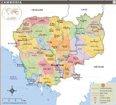
This political map of Cambodia displays the country's provincial boundaries, major cities, roads and river systems in detail. Each province is color-coded for easy identification, with clear labels for capitals and major cities such as Phnom Penh, Siem Reap, Battambang and Sihanoukville. The national capital, Phnom Penh, is prominently marked with a red square, reflecting its central role in governance and connectivity. The map shows Cambodia's geographic neighbors - Thailand to the west and northwest, Laos to the north and Vietnam to the east and southeast. Major rivers such as the Mekong and Tonle Sap are accurately depicted, emphasizing the country's rich water resources and agricultural backbone.
Major highways and roads connecting the various provinces provide information about Cambodia's infrastructure. This map is ideal for educational, informational or reference use, giving the viewer a clear visual understanding of Cambodia's administrative layout, transportation routes and border regions. It also includes nearby water bodies such as the Gulf of Thailand.
Frequently Asked Questions about the Cambodia
1. Where is Cambodia located?
Cambodia is a country in Southeast Asia. It is bordered by Thailand to the northwest, Laos to the north, Vietnam to the east, and the Gulf of Thailand to the southwest.
2. What is the capital of Cambodia?
Phnom Penh is the capital and largest city of Cambodia. It serves as the country's political, economic, and cultural center.
4. What is the population of Cambodia?
Cambodia has a population of approximately 17 million people, though the exact figure changes as new census and population estimates are released..
4. What language is spoken in Cambodia?
Burmese is the official language of Cambodia and is spoken by the majority of the population.
5. What language is spoken in Cambodia?
Khmer is the official language of Cambodia and is spoken by the majority of the population.
6. What currency is used in Cambodia?
The official currency of Cambodia is the Cambodian Riel (KHR), although the US Dollar is also widely accepted in many parts of the country.
7. What are the major tourist attractions in Cambodia?
Popular attractions include Angkor Wat, Phnom Penh, Tonlé Sap Lake, and the beaches of Sihanoukville, which attract visitors from around the world.
- Afghanistan
- Albania
- Algeria
- Andorra
- Angola
- Antigua and Barbuda
- Argentina
- Armenia
- Australia
- Austria
- Azerbaijan
- Bahrain
- Bangladesh
- Barbados
- Belarus
- Belgium
- Belize
- Benin
- Bhutan
- Bolivia
- Bosnia and Herzegovina
- Botswana
- Brazil
- Brunei
- Bulgaria
- Burkina Faso
- Burma (Myanmar)
- Burundi
- Cabo Verde
- Cambodia
- Cameroon
- Canada
- Central African Republic
- Chad
- Chile
- China
- Colombia
- Comoros Islands
- Democratic Republic of the Congo
- Costa Rica
- Cote d'Ivoire
- Croatia
- Cuba
- Cyprus
- Czechia
- Denmark
- Djibouti
- Dominica
- Dominican Republic
- Ecuador
- Egypt
- El Salvador
- England
- Equatorial Guinea
- Eritrea
- Estonia
- eSwatini (formerly Swaziland)
- Ethiopia
- Federated States of Micronesia
- Fiji
- Finland
- France
- Gabon
- The Gambia
- Georgia
- Germany
- Ghana
- Greece
- Grenada
- Guatemala
- Guinea
- Guinea-Bissau
- Guyana
- Haiti
- Holy See
- Honduras
- Hungary
- Iceland
- India
- Indonesia
- Iran
- Iraq
- Ireland
- Israel
- Italy
- Jamaica
- Japan
- Jordan
- Kazakhstan
- Kenya
- Kiribati
- Kosovo
- Kuwait
- Kyrgyzstan
- Laos
- Latvia
- Lebanon
- Lesotho
- Liberia
- Libya
- Liechtenstein
- Lithuania
- Luxembourg
- Madagascar
- Malawi
- Malaysia
- Maldives
- Mali
- Malta
- Marshall Islands
- Mauritania
- Mauritius
- Mexico
- Moldova
- Monaco
- Mongolia
- Montenegro
- Morocco
- Mozambique
- Namibia
- Nauru
- Nepal
- Netherlands
- New Zealand
- Nicaragua
- Niger
- Nigeria
- North Korea
- Northern Ireland
- Norway
- Oman
- Pakistan
- Palau
- Panama
- Papua New Guinea
- Paraguay
- Peru
- Philippines
- Poland
- Portugal
- Puerto Rico (USA)
- Qatar
- North Macedonia
- Romania
- Russia
- Rwanda
- Saint Kitts and Nevis
- Saint Lucia
- Saint Vincent & the Grenadines
- Samoa
- San Marino
- Sao Tome and Principe
- Saudi Arabia
- Scotland
- Senegal
- Serbia
- Seychelles
- Sierra Leone
- Singapore
- Slovakia
- Slovenia
- Solomon Islands
- Somalia
- South Africa
- South Korea
- South Sudan
- Spain
- Sri Lanka
- Sudan
- Suriname
- Sweden
- Switzerland
- Syria
- Tajikistan
- Taiwan
- Tanzania
- Thailand
- The Bahamas
- Timor-Leste
- Togo
- Tonga
- Trinidad and Tobago
- Tunisia
- Turkey
- Turkmenistan
- Tuvalu
- Uganda
- Ukraine
- United Arab Emirates
- United Kingdom
- United States of America
- Uruguay
- Uzbekistan
- Vanuatu
- Western Sahara
- Venezuela
- Vietnam
- Wales
- Yemen
- Zambia
- Zimbabwe
