CYPRUS MAP

About Cyprus Map
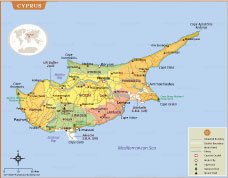
Explore the island nation of Cyprus with this detailed political map featuring district boundaries, major cities, towns, rivers, highways, mountain peaks, and important landmarks. The map clearly identifies Nicosia, Limassol, Larnaca, Paphos, Famagusta, Kyrenia, and the UN Buffer Zone, making it an excellent reference for geography, education, travel planning, and research. Coastal features, national parks, and key capes are also accurately marked.
Designed with clarity and accuracy, this high-resolution Cyprus map is ideal for classrooms, offices, presentations, websites, and personal study. It highlights major transportation routes, administrative divisions, and important natural features across the island. Whether you are learning about Cyprus, preparing educational materials, or creating travel content, this printable map provides a comprehensive overview of one of the Mediterranean's most historically significant and geographically diverse countries.
Frequently Asked Questions about the Cyprus
1. Where is Cyprus located?
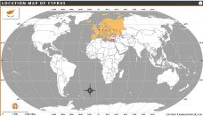
Cyprus is an island country in the eastern Mediterranean Sea. It lies south of Turkey, west of Syria and Lebanon, northwest of Israel, and north of Egypt, making it a strategic crossroads between Europe, Asia, and Africa.
2. What is the capital of Cyprus?
The capital city of Cyprus is Nicosia, which is the world's last divided capital. It is separated by the United Nations Buffer Zone between the Republic of Cyprus and the northern part of the island.
3. Is Cyprus part of the European Union?
Yes. Cyprus became a member of the European Union (EU) on May 1, 2004. It also uses the Euro (€) as its official currency, although the euro is not officially used in Northern Cyprus.
4. What languages are spoken in Cyprus?
The official languages of the Republic of Cyprus are Greek and Turkish. English is also widely spoken, especially in tourism, business, and education.
5. What is Cyprus famous for?
Cyprus is known for its beautiful Mediterranean beaches, ancient archaeological sites, Byzantine churches, mountain villages, rich history, and as the legendary birthplace of Aphrodite, the Greek goddess of love.
6. Why is Cyprus divided?
Cyprus has been divided since 1974 following a Greek-backed coup and subsequent Turkish military intervention. The island is separated by a United Nations Buffer Zone, with the Republic of Cyprus controlling the south and the Turkish Cypriot-administered north controlling the northern part.
7. What are the major cities in Cyprus?
The major cities of Cyprus include Nicosia (capital), Limassol, Larnaca, Paphos, Famagusta, and Kyrenia. These cities are important centers for government, tourism, trade, education, and culture.
- Afghanistan
- Albania
- Algeria
- Andorra
- Angola
- Antigua and Barbuda
- Argentina
- Armenia
- Australia
- Austria
- Azerbaijan
- Bahrain
- Bangladesh
- Barbados
- Belarus
- Belgium
- Belize
- Benin
- Bhutan
- Bolivia
- Bosnia and Herzegovina
- Botswana
- Brazil
- Brunei
- Bulgaria
- Burkina Faso
- Burma (Myanmar)
- Burundi
- Cabo Verde
- Cambodia
- Cameroon
- Canada
- Central African Republic
- Chad
- Chile
- China
- Colombia
- Comoros Islands
- Democratic Republic of the Congo
- Costa Rica
- Cote d'Ivoire
- Croatia
- Cuba
- Cyprus
- Czechia
- Denmark
- Djibouti
- Dominica
- Dominican Republic
- Ecuador
- Egypt
- El Salvador
- England
- Equatorial Guinea
- Eritrea
- Estonia
- eSwatini (formerly Swaziland)
- Ethiopia
- Federated States of Micronesia
- Fiji
- Finland
- France
- Gabon
- The Gambia
- Georgia
- Germany
- Ghana
- Greece
- Grenada
- Guatemala
- Guinea
- Guinea-Bissau
- Guyana
- Haiti
- Holy See
- Honduras
- Hungary
- Iceland
- India
- Indonesia
- Iran
- Iraq
- Ireland
- Israel
- Italy
- Jamaica
- Japan
- Jordan
- Kazakhstan
- Kenya
- Kiribati
- Kosovo
- Kuwait
- Kyrgyzstan
- Laos
- Latvia
- Lebanon
- Lesotho
- Liberia
- Libya
- Liechtenstein
- Lithuania
- Luxembourg
- Madagascar
- Malawi
- Malaysia
- Maldives
- Mali
- Malta
- Marshall Islands
- Mauritania
- Mauritius
- Mexico
- Moldova
- Monaco
- Mongolia
- Montenegro
- Morocco
- Mozambique
- Namibia
- Nauru
- Nepal
- Netherlands
- New Zealand
- Nicaragua
- Niger
- Nigeria
- North Korea
- Northern Ireland
- Norway
- Oman
- Pakistan
- Palau
- Panama
- Papua New Guinea
- Paraguay
- Peru
- Philippines
- Poland
- Portugal
- Puerto Rico (USA)
- Qatar
- North Macedonia
- Romania
- Russia
- Rwanda
- Saint Kitts and Nevis
- Saint Lucia
- Saint Vincent & the Grenadines
- Samoa
- San Marino
- Sao Tome and Principe
- Saudi Arabia
- Scotland
- Senegal
- Serbia
- Seychelles
- Sierra Leone
- Singapore
- Slovakia
- Slovenia
- Solomon Islands
- Somalia
- South Africa
- South Korea
- South Sudan
- Spain
- Sri Lanka
- Sudan
- Suriname
- Sweden
- Switzerland
- Syria
- Tajikistan
- Taiwan
- Tanzania
- Thailand
- The Bahamas
- Timor-Leste
- Togo
- Tonga
- Trinidad and Tobago
- Tunisia
- Turkey
- Turkmenistan
- Tuvalu
- Uganda
- Ukraine
- United Arab Emirates
- United Kingdom
- United States of America
- Uruguay
- Uzbekistan
- Vanuatu
- Western Sahara
- Venezuela
- Vietnam
- Wales
- Yemen
- Zambia
- Zimbabwe
