DENMARK MAP

About Denmark Map
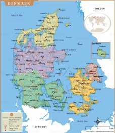
Explore Denmark with this detailed political map featuring its five administrative regions, major cities, islands, highways, rivers, and surrounding seas. The map highlights Copenhagen, Aarhus, Odense, Aalborg, Esbjerg, and other important towns, along with the Jutland Peninsula and islands such as Zealand, Funen, Bornholm, Lolland, and Falster. It also shows neighboring countries and major water bodies, including the North Sea and Baltic Sea.
This high-resolution Denmark map is perfect for students, teachers, travelers, researchers, and businesses seeking accurate geographic information. Clearly marked regional boundaries, transportation networks, and natural features make it an excellent educational and reference resource. Whether you're planning a trip, studying Danish geography, or creating presentations, this printable map offers a comprehensive overview of Denmark's landscape, infrastructure, and administrative divisions with exceptional clarity and detail.
Frequently Asked Questions about the Denmark
1. Where is Denmark located?
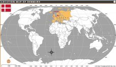
Denmark is a Nordic country in Northern Europe. It borders Germany to the south and is surrounded by the North Sea and Baltic Sea.
2. What is the capital of Denmark?
The capital of Denmark is Copenhagen, the country's largest city and its political, cultural, and economic center.
3. What is Denmark famous for?
Denmark is known for its Viking history, high quality of life, renewable energy leadership, fairy tales by Hans Christian Andersen, LEGO, and beautiful coastal landscapes.
4. What language is spoken in Denmark?
The official language is Danish. English is widely spoken, and many Danes also understand German and other Scandinavian languages.
5. What currency does Denmark use?
Denmark uses the Danish Krone (DKK) as its official currency. Although it is a member of the European Union, it has not adopted the Euro.
6. Is Denmark part of the European Union?
Yes, Denmark has been a member of the European Union (EU) since 1973. However, it retains its own currency, the Danish Krone.
7. What are the major cities in Denmark?
The major cities in Denmark include Copenhagen, Aarhus, Odense, Aalborg, Esbjerg, Randers, Kolding, and Horsens, which are important centers for business, education, culture, and tourism.

- Afghanistan
- Albania
- Algeria
- Andorra
- Angola
- Antigua and Barbuda
- Argentina
- Armenia
- Australia
- Austria
- Azerbaijan
- Bahrain
- Bangladesh
- Barbados
- Belarus
- Belgium
- Belize
- Benin
- Bhutan
- Bolivia
- Bosnia and Herzegovina
- Botswana
- Brazil
- Brunei
- Bulgaria
- Burkina Faso
- Burma (Myanmar)
- Burundi
- Cabo Verde
- Cambodia
- Cameroon
- Canada
- Central African Republic
- Chad
- Chile
- China
- Colombia
- Comoros Islands
- Democratic Republic of the Congo
- Costa Rica
- Cote d'Ivoire
- Croatia
- Cuba
- Cyprus
- Czechia
- Denmark
- Djibouti
- Dominica
- Dominican Republic
- Ecuador
- Egypt
- El Salvador
- England
- Equatorial Guinea
- Eritrea
- Estonia
- eSwatini (formerly Swaziland)
- Ethiopia
- Federated States of Micronesia
- Fiji
- Finland
- France
- Gabon
- The Gambia
- Georgia
- Germany
- Ghana
- Greece
- Grenada
- Guatemala
- Guinea
- Guinea-Bissau
- Guyana
- Haiti
- Holy See
- Honduras
- Hungary
- Iceland
- India
- Indonesia
- Iran
- Iraq
- Ireland
- Israel
- Italy
- Jamaica
- Japan
- Jordan
- Kazakhstan
- Kenya
- Kiribati
- Kosovo
- Kuwait
- Kyrgyzstan
- Laos
- Latvia
- Lebanon
- Lesotho
- Liberia
- Libya
- Liechtenstein
- Lithuania
- Luxembourg
- Madagascar
- Malawi
- Malaysia
- Maldives
- Mali
- Malta
- Marshall Islands
- Mauritania
- Mauritius
- Mexico
- Moldova
- Monaco
- Mongolia
- Montenegro
- Morocco
- Mozambique
- Namibia
- Nauru
- Nepal
- Netherlands
- New Zealand
- Nicaragua
- Niger
- Nigeria
- North Korea
- Northern Ireland
- Norway
- Oman
- Pakistan
- Palau
- Panama
- Papua New Guinea
- Paraguay
- Peru
- Philippines
- Poland
- Portugal
- Puerto Rico (USA)
- Qatar
- North Macedonia
- Romania
- Russia
- Rwanda
- Saint Kitts and Nevis
- Saint Lucia
- Saint Vincent & the Grenadines
- Samoa
- San Marino
- Sao Tome and Principe
- Saudi Arabia
- Scotland
- Senegal
- Serbia
- Seychelles
- Sierra Leone
- Singapore
- Slovakia
- Slovenia
- Solomon Islands
- Somalia
- South Africa
- South Korea
- South Sudan
- Spain
- Sri Lanka
- Sudan
- Suriname
- Sweden
- Switzerland
- Syria
- Tajikistan
- Taiwan
- Tanzania
- Thailand
- The Bahamas
- Timor-Leste
- Togo
- Tonga
- Trinidad and Tobago
- Tunisia
- Turkey
- Turkmenistan
- Tuvalu
- Uganda
- Ukraine
- United Arab Emirates
- United Kingdom
- United States of America
- Uruguay
- Uzbekistan
- Vanuatu
- Western Sahara
- Venezuela
- Vietnam
- Wales
- Yemen
- Zambia
- Zimbabwe
