AFGHANISTAN MAP

About Afghanistan Map
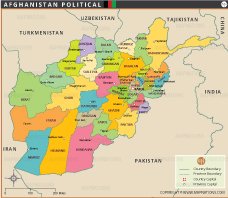
Afghanistan is a landlocked country located in South-Central Asia. Its landscape includes diverse geographic features such as mountains, deserts, and river valleys. The prominent Hindu Kush mountain range located in the northeastern region includes peaks such as Noshaq (7,492 m). Afghanistan's first national park, the Band-e Amir National Park, is located in central Bamyan Province.
Afghanistan shares borders with six countries: Pakistan (southeast/south), Iran (west), Turkmenistan, Uzbekistan, Tajikistan (north), and China (northeast).
Kabul, the capital city and largest metropolitan area, serves as the country's political and economic center. Other major cities include Kandahar, Herat, Mazar-e-Sharif, and Jalalabad, which are well connected by major roads. These urban centers are important for commerce, culture, and governance.
The map depicts major rivers such as the Amu Darya, Helmand, and Kabul, which play a vital role in agriculture and livelihoods. The road network connects major cities, facilitating transportation and trade. International airports in cities such as Kabul and Kandahar also connect Afghanistan to the global community.
Notable sites include natural attractions such as Goud-e-Zereh and areas of ecological importance such as Band-e-Amir National Park, which underscore Afghanistan's rich environmental heritage.
This map is an excellent resource for understanding Afghanistan's geography, infrastructure, and regional importance.
Frequently Asked Questions about the Afghanistan
1. Where is Afghanistan located?
Afghanistan is a landlocked country located in South Asia and Central Asia. It shares borders with Pakistan, Iran, Turkmenistan, Uzbekistan, Tajikistan, and China.
2. What is the capital city of Afghanistan?
The capital and largest city of Afghanistan is Kabul, which serves as the country’s political, cultural, and economic center.
3. What are the major provinces of Afghanistan?
Afghanistan has 34 provinces including Herat, Kandahar, Balkh, Nangarhar, Badakhshan, Helmand, and Kunduz.
4. Which countries border Afghanistan?
Afghanistan borders Pakistan, Iran, Turkmenistan, Uzbekistan, Tajikistan, and China through the narrow Wakhan Corridor.
5. What are the major physical features of Afghanistan?
Afghanistan is known for rugged mountains, deserts, valleys, and rivers. The Hindu Kush mountain range is one of its most important geographical features.
6. What language is spoken in Afghanistan?
The two official languages of Afghanistan are Dari (Persian) and Pashto. Several regional languages are also spoken across the country.
7. What is Afghanistan famous for?
Afghanistan is famous for its strategic location, ancient Silk Road history, mountainous landscapes, cultural heritage, carpets, and historical cities such as Kabul, Herat, and Kandahar.


- Afghanistan
- Albania
- Algeria
- Andorra
- Angola
- Antigua and Barbuda
- Argentina
- Armenia
- Australia
- Austria
- Azerbaijan
- Bahrain
- Bangladesh
- Barbados
- Belarus
- Belgium
- Belize
- Benin
- Bhutan
- Bolivia
- Bosnia and Herzegovina
- Botswana
- Brazil
- Brunei
- Bulgaria
- Burkina Faso
- Burma (Myanmar)
- Burundi
- Cabo Verde
- Cambodia
- Cameroon
- Canada
- Central African Republic
- Chad
- Chile
- China
- Colombia
- Comoros Islands
- Democratic Republic of the Congo
- Costa Rica
- Cote d'Ivoire
- Croatia
- Cuba
- Cyprus
- Czechia
- Denmark
- Djibouti
- Dominica
- Dominican Republic
- Ecuador
- Egypt
- El Salvador
- England
- Equatorial Guinea
- Eritrea
- Estonia
- eSwatini (formerly Swaziland)
- Ethiopia
- Federated States of Micronesia
- Fiji
- Finland
- France
- Gabon
- The Gambia
- Georgia
- Germany
- Ghana
- Greece
- Grenada
- Guatemala
- Guinea
- Guinea-Bissau
- Guyana
- Haiti
- Holy See
- Honduras
- Hungary
- Iceland
- India
- Indonesia
- Iran
- Iraq
- Ireland
- Israel
- Italy
- Jamaica
- Japan
- Jordan
- Kazakhstan
- Kenya
- Kiribati
- Kosovo
- Kuwait
- Kyrgyzstan
- Laos
- Latvia
- Lebanon
- Lesotho
- Liberia
- Libya
- Liechtenstein
- Lithuania
- Luxembourg
- Madagascar
- Malawi
- Malaysia
- Maldives
- Mali
- Malta
- Marshall Islands
- Mauritania
- Mauritius
- Mexico
- Moldova
- Monaco
- Mongolia
- Montenegro
- Morocco
- Mozambique
- Namibia
- Nauru
- Nepal
- Netherlands
- New Zealand
- Nicaragua
- Niger
- Nigeria
- North Korea
- Northern Ireland
- Norway
- Oman
- Pakistan
- Palau
- Panama
- Papua New Guinea
- Paraguay
- Peru
- Philippines
- Poland
- Portugal
- Puerto Rico (USA)
- Qatar
- North Macedonia
- Romania
- Russia
- Rwanda
- Saint Kitts and Nevis
- Saint Lucia
- Saint Vincent & the Grenadines
- Samoa
- San Marino
- Sao Tome and Principe
- Saudi Arabia
- Scotland
- Senegal
- Serbia
- Seychelles
- Sierra Leone
- Singapore
- Slovakia
- Slovenia
- Solomon Islands
- Somalia
- South Africa
- South Korea
- South Sudan
- Spain
- Sri Lanka
- Sudan
- Suriname
- Sweden
- Switzerland
- Syria
- Tajikistan
- Taiwan
- Tanzania
- Thailand
- The Bahamas
- Timor-Leste
- Togo
- Tonga
- Trinidad and Tobago
- Tunisia
- Turkey
- Turkmenistan
- Tuvalu
- Uganda
- Ukraine
- United Arab Emirates
- United Kingdom
- United States of America
- Uruguay
- Uzbekistan
- Vanuatu
- Western Sahara
- Venezuela
- Vietnam
- Wales
- Yemen
- Zambia
- Zimbabwe
