BELARUS MAP

About Belarus Map
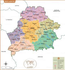
This Belarus map provides an in-depth view of the Eastern European country, highlighting its districts, major cities, and international borders. The map features the capital city, Minsk, located centrally, along with other important regional capitals such as Brest, Grodno, Gomel, Mogilev, and Vitebsk. Clear district boundaries, major roads, and rivers are outlined to showcase the country’s geographic and infrastructural layout. Belarus shares borders with Russia to the northeast, Ukraine to the south, Poland to the west, and Latvia and Lithuania to the northwest, placing it at a key crossroads in Europe. The map also emphasizes important towns, regional divisions, and natural features, making it a useful reference for students, researchers, and travelers exploring Belarus’s cultural and geopolitical significance.
Frequently Asked Questions about the Belarus
1. Where is Belarus located?
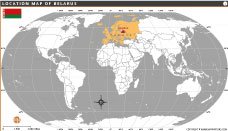
Belarus is a landlocked country in Eastern Europe. It shares borders with Russia, Ukraine, Poland, Lithuania, and Latvia. The capital city is Minsk.
2. What is Belarus famous for?
Belarus is known for its dense forests, Soviet-era architecture, tractors manufacturing, and beautiful national parks like Belovezhskaya Pushcha. It is also famous for preserving European bison.
3. What is the capital of Belarus?
The capital and largest city of Belarus is Minsk. It is the political, cultural, and economic center of the country.
4. What language is spoken in Belarus?
The official languages of Belarus are Belarusian and Russian. Russian is more commonly spoken in daily life across the country.
5. What currency is used in Belarus?
Belarus uses the Belarusian Ruble (BYN) as its official currency.
6. What are the top tourist attractions in Belarus?
Popular attractions include Belovezhskaya Pushcha National Park, Mir Castle, Nesvizh Castle, and the historic streets of Minsk.
7. What is the climate like in Belarus?
Belarus has a moderate continental climate with cold winters and mild to warm summers. Snowfall is common during winter months.
- Afghanistan
- Albania
- Algeria
- Andorra
- Angola
- Antigua and Barbuda
- Argentina
- Armenia
- Australia
- Austria
- Azerbaijan
- Bahrain
- Bangladesh
- Barbados
- Belarus
- Belgium
- Belize
- Benin
- Bhutan
- Bolivia
- Bosnia and Herzegovina
- Botswana
- Brazil
- Brunei
- Bulgaria
- Burkina Faso
- Burma (Myanmar)
- Burundi
- Cabo Verde
- Cambodia
- Cameroon
- Canada
- Central African Republic
- Chad
- Chile
- China
- Colombia
- Comoros Islands
- Democratic Republic of the Congo
- Costa Rica
- Cote d'Ivoire
- Croatia
- Cuba
- Cyprus
- Czechia
- Denmark
- Djibouti
- Dominica
- Dominican Republic
- Ecuador
- Egypt
- El Salvador
- England
- Equatorial Guinea
- Eritrea
- Estonia
- eSwatini (formerly Swaziland)
- Ethiopia
- Federated States of Micronesia
- Fiji
- Finland
- France
- Gabon
- The Gambia
- Georgia
- Germany
- Ghana
- Greece
- Grenada
- Guatemala
- Guinea
- Guinea-Bissau
- Guyana
- Haiti
- Holy See
- Honduras
- Hungary
- Iceland
- India
- Indonesia
- Iran
- Iraq
- Ireland
- Israel
- Italy
- Jamaica
- Japan
- Jordan
- Kazakhstan
- Kenya
- Kiribati
- Kosovo
- Kuwait
- Kyrgyzstan
- Laos
- Latvia
- Lebanon
- Lesotho
- Liberia
- Libya
- Liechtenstein
- Lithuania
- Luxembourg
- Madagascar
- Malawi
- Malaysia
- Maldives
- Mali
- Malta
- Marshall Islands
- Mauritania
- Mauritius
- Mexico
- Moldova
- Monaco
- Mongolia
- Montenegro
- Morocco
- Mozambique
- Namibia
- Nauru
- Nepal
- Netherlands
- New Zealand
- Nicaragua
- Niger
- Nigeria
- North Korea
- Northern Ireland
- Norway
- Oman
- Pakistan
- Palau
- Panama
- Papua New Guinea
- Paraguay
- Peru
- Philippines
- Poland
- Portugal
- Puerto Rico (USA)
- Qatar
- North Macedonia
- Romania
- Russia
- Rwanda
- Saint Kitts and Nevis
- Saint Lucia
- Saint Vincent & the Grenadines
- Samoa
- San Marino
- Sao Tome and Principe
- Saudi Arabia
- Scotland
- Senegal
- Serbia
- Seychelles
- Sierra Leone
- Singapore
- Slovakia
- Slovenia
- Solomon Islands
- Somalia
- South Africa
- South Korea
- South Sudan
- Spain
- Sri Lanka
- Sudan
- Suriname
- Sweden
- Switzerland
- Syria
- Tajikistan
- Taiwan
- Tanzania
- Thailand
- The Bahamas
- Timor-Leste
- Togo
- Tonga
- Trinidad and Tobago
- Tunisia
- Turkey
- Turkmenistan
- Tuvalu
- Uganda
- Ukraine
- United Arab Emirates
- United Kingdom
- United States of America
- Uruguay
- Uzbekistan
- Vanuatu
- Western Sahara
- Venezuela
- Vietnam
- Wales
- Yemen
- Zambia
- Zimbabwe
