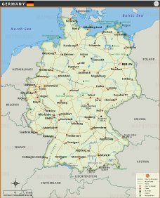
GERMANY MAP
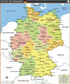
This detailed map of Germany provides a comprehensive overview of the country's geography, cities and transportation network. It depicts Germany's major cities, including the capital Berlin, as well as Hamburg, Munich, Frankfurt and Cologne. Each city is clearly marked, making it easy to identify major urban centers across the country. The map also shows Germany's road network, including major highways and routes that connect cities, facilitating travel and trade.

Rivers such as the Rhine, Elbe and Danube are prominently displayed, emphasizing their importance to the country's economy and landscape. Major geographic features such as the Black Forest in the southwest, the Zugspitze (Germany's highest peak), and Lake Constance are also noted, providing insight into the country's diverse terrain. Borders with neighboring countries such as France, Poland, Austria, and the Netherlands are clearly defined, reflecting Germany's central position in Europe.
This map also includes national parks and protected areas, such as Berchtesgaden National Park, which showcase Germany's natural beauty and commitment to conservation. Additionally, features such as major airports and national landmarks make the map useful for both travelers and researchers.


Frequently Asked Questions about the Germany
1. What is the capital of Germany?
The capital city of Germany is Berlin, which is also the country’s largest city and a major cultural and political center.
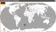
2. Where is Germany located?
Germany is located in Central Europe and shares borders with nine countries, including France, Poland, Austria, and the Netherlands.
3. What is Germany famous for?
Germany is known for its engineering, automobiles, castles, Oktoberfest, football culture, and historic landmarks like the Brandenburg Gate.
4. What language is spoken in Germany?
German is the official language of Germany. English is also widely understood in major cities and tourist areas.
5. What currency does Germany use?
Germany uses the Euro (€) as its official currency because it is a member of the European Union.
6. What are the major cities in Germany?
Some major German cities include Berlin, Munich, Hamburg, Frankfurt, Cologne, Stuttgart, and Dresden.
7. What is the best time to visit Germany?
The best time to visit Germany is from May to September for pleasant weather, festivals, sightseeing, and outdoor activities.
- Afghanistan
- Albania
- Algeria
- Andorra
- Angola
- Antigua and Barbuda
- Argentina
- Armenia
- Australia
- Austria
- Azerbaijan
- Bahrain
- Bangladesh
- Barbados
- Belarus
- Belgium
- Belize
- Benin
- Bhutan
- Bolivia
- Bosnia and Herzegovina
- Botswana
- Brazil
- Brunei
- Bulgaria
- Burkina Faso
- Burma (Myanmar)
- Burundi
- Cabo Verde
- Cambodia
- Cameroon
- Canada
- Central African Republic
- Chad
- Chile
- China
- Colombia
- Comoros Islands
- Democratic Republic of the Congo
- Costa Rica
- Cote d'Ivoire
- Croatia
- Cuba
- Cyprus
- Czechia
- Denmark
- Djibouti
- Dominica
- Dominican Republic
- Ecuador
- Egypt
- El Salvador
- England
- Equatorial Guinea
- Eritrea
- Estonia
- eSwatini (formerly Swaziland)
- Ethiopia
- Federated States of Micronesia
- Fiji
- Finland
- France
- Gabon
- The Gambia
- Georgia
- Germany
- Ghana
- Greece
- Grenada
- Guatemala
- Guinea
- Guinea-Bissau
- Guyana
- Haiti
- Holy See
- Honduras
- Hungary
- Iceland
- India
- Indonesia
- Iran
- Iraq
- Ireland
- Israel
- Italy
- Jamaica
- Japan
- Jordan
- Kazakhstan
- Kenya
- Kiribati
- Kosovo
- Kuwait
- Kyrgyzstan
- Laos
- Latvia
- Lebanon
- Lesotho
- Liberia
- Libya
- Liechtenstein
- Lithuania
- Luxembourg
- Madagascar
- Malawi
- Malaysia
- Maldives
- Mali
- Malta
- Marshall Islands
- Mauritania
- Mauritius
- Mexico
- Moldova
- Monaco
- Mongolia
- Montenegro
- Morocco
- Mozambique
- Namibia
- Nauru
- Nepal
- Netherlands
- New Zealand
- Nicaragua
- Niger
- Nigeria
- North Korea
- Northern Ireland
- Norway
- Oman
- Pakistan
- Palau
- Panama
- Papua New Guinea
- Paraguay
- Peru
- Philippines
- Poland
- Portugal
- Puerto Rico (USA)
- Qatar
- North Macedonia
- Romania
- Russia
- Rwanda
- Saint Kitts and Nevis
- Saint Lucia
- Saint Vincent & the Grenadines
- Samoa
- San Marino
- Sao Tome and Principe
- Saudi Arabia
- Scotland
- Senegal
- Serbia
- Seychelles
- Sierra Leone
- Singapore
- Slovakia
- Slovenia
- Solomon Islands
- Somalia
- South Africa
- South Korea
- South Sudan
- Spain
- Sri Lanka
- Sudan
- Suriname
- Sweden
- Switzerland
- Syria
- Tajikistan
- Taiwan
- Tanzania
- Thailand
- The Bahamas
- Timor-Leste
- Togo
- Tonga
- Trinidad and Tobago
- Tunisia
- Turkey
- Turkmenistan
- Tuvalu
- Uganda
- Ukraine
- United Arab Emirates
- United Kingdom
- United States of America
- Uruguay
- Uzbekistan
- Vanuatu
- Western Sahara
- Venezuela
- Vietnam
- Wales
- Yemen
- Zambia
- Zimbabwe
