COLOMBIA MAP

About Colombia Map
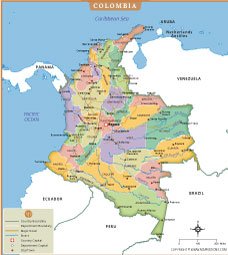
This detailed map of Colombia illustrates the country's administrative divisions, including all departments, department capitals, major cities, rivers, and transportation routes. The map highlights important urban centers such as Bogotá, Medellín, Cali, Cartagena, Barranquilla, and Bucaramanga, providing a clear understanding of Colombia's regional structure and connectivity.
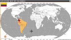
Colombia is located in northwestern South America and shares borders with Panama, Venezuela, Brazil, Peru, and Ecuador. The map also displays major rivers, coastlines along the Caribbean Sea and Pacific Ocean, and key road networks connecting different regions. Distinct color coding helps identify each department, making the map useful for educational, geographic, travel, and research purposes. This high-quality Colombia map serves as a valuable reference for students, teachers, travelers, and professionals seeking accurate geographic information about the country.
Frequently Asked Questions about the Cambodia
1. Where is Colombia located?
Colombia is located in northwestern South America. It borders Panama, Venezuela, Brazil, Peru, and Ecuador, with coastlines on both the Caribbean Sea and Pacific Ocean.
2. What is the capital of Colombia?
Bogotá is the capital and largest city of Colombia. It serves as the country's political, economic, and cultural center.
3. How many departments are there in Colombia?
Colombia is divided into 32 departments and one Capital District (Bogotá), each with its own administrative government.
4. What are the major cities shown on the Colombia map?
Major cities include Bogotá, Medellín, Cali, Cartagena, Barranquilla, Bucaramanga, Cúcuta, and Pereira.
5. Which countries border Colombia?
Colombia shares international borders with Panama, Venezuela, Brazil, Peru, and Ecuador.
6. What information does a political map of Colombia provide?
A political map shows department boundaries, capitals, major cities, roads, rivers, and neighboring countries, helping users understand Colombia's administrative divisions.
7. Why is Colombia important in South America?
Colombia is one of South America's largest economies and is known for its biodiversity, coffee production, cultural heritage, and strategic location connecting Central and South America.
- Afghanistan
- Albania
- Algeria
- Andorra
- Angola
- Antigua and Barbuda
- Argentina
- Armenia
- Australia
- Austria
- Azerbaijan
- Bahrain
- Bangladesh
- Barbados
- Belarus
- Belgium
- Belize
- Benin
- Bhutan
- Bolivia
- Bosnia and Herzegovina
- Botswana
- Brazil
- Brunei
- Bulgaria
- Burkina Faso
- Burma (Myanmar)
- Burundi
- Cabo Verde
- Cambodia
- Cameroon
- Canada
- Central African Republic
- Chad
- Chile
- China
- Colombia
- Comoros Islands
- Democratic Republic of the Congo
- Costa Rica
- Cote d'Ivoire
- Croatia
- Cuba
- Cyprus
- Czechia
- Denmark
- Djibouti
- Dominica
- Dominican Republic
- Ecuador
- Egypt
- El Salvador
- England
- Equatorial Guinea
- Eritrea
- Estonia
- eSwatini (formerly Swaziland)
- Ethiopia
- Federated States of Micronesia
- Fiji
- Finland
- France
- Gabon
- The Gambia
- Georgia
- Germany
- Ghana
- Greece
- Grenada
- Guatemala
- Guinea
- Guinea-Bissau
- Guyana
- Haiti
- Holy See
- Honduras
- Hungary
- Iceland
- India
- Indonesia
- Iran
- Iraq
- Ireland
- Israel
- Italy
- Jamaica
- Japan
- Jordan
- Kazakhstan
- Kenya
- Kiribati
- Kosovo
- Kuwait
- Kyrgyzstan
- Laos
- Latvia
- Lebanon
- Lesotho
- Liberia
- Libya
- Liechtenstein
- Lithuania
- Luxembourg
- Madagascar
- Malawi
- Malaysia
- Maldives
- Mali
- Malta
- Marshall Islands
- Mauritania
- Mauritius
- Mexico
- Moldova
- Monaco
- Mongolia
- Montenegro
- Morocco
- Mozambique
- Namibia
- Nauru
- Nepal
- Netherlands
- New Zealand
- Nicaragua
- Niger
- Nigeria
- North Korea
- Northern Ireland
- Norway
- Oman
- Pakistan
- Palau
- Panama
- Papua New Guinea
- Paraguay
- Peru
- Philippines
- Poland
- Portugal
- Puerto Rico (USA)
- Qatar
- North Macedonia
- Romania
- Russia
- Rwanda
- Saint Kitts and Nevis
- Saint Lucia
- Saint Vincent & the Grenadines
- Samoa
- San Marino
- Sao Tome and Principe
- Saudi Arabia
- Scotland
- Senegal
- Serbia
- Seychelles
- Sierra Leone
- Singapore
- Slovakia
- Slovenia
- Solomon Islands
- Somalia
- South Africa
- South Korea
- South Sudan
- Spain
- Sri Lanka
- Sudan
- Suriname
- Sweden
- Switzerland
- Syria
- Tajikistan
- Taiwan
- Tanzania
- Thailand
- The Bahamas
- Timor-Leste
- Togo
- Tonga
- Trinidad and Tobago
- Tunisia
- Turkey
- Turkmenistan
- Tuvalu
- Uganda
- Ukraine
- United Arab Emirates
- United Kingdom
- United States of America
- Uruguay
- Uzbekistan
- Vanuatu
- Western Sahara
- Venezuela
- Vietnam
- Wales
- Yemen
- Zambia
- Zimbabwe
