CROATIA MAP

About Croatia Map
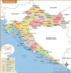
This map of Croatia highlights the country’s administrative counties, major cities, and important transportation routes. Each county is distinctly colored, making it easy to understand regional boundaries and identify key urban centers such as Zagreb, Split, Rijeka, Osijek, and Zadar. The map also showcases Croatia’s extensive Adriatic coastline, including major islands like Krk, Hvar, Brač, and Korčula, which are integral to the nation’s geography and tourism.
Rivers such as the Danube, Drava, and Sava are clearly marked, along with notable national parks including Plitvice Lakes. Surrounding countries—Slovenia, Hungary, Serbia, Bosnia and Herzegovina, and Montenegro—are shown for geographical context. This map serves as an excellent reference for travelers, students, and anyone seeking a clear visual understanding of Croatia’s landscape and administrative structure.
Frequently Asked Questions about the Croatia
1. What is Croatia best known for?
Croatia is famous for its beautiful Adriatic coastline, over 1,000 islands, historic cities like Dubrovnik and Split, UNESCO World Heritage Sites, and stunning national parks such as Plitvice Lakes.
2. What is the capital of Croatia?
The capital of Croatia is Zagreb, located in the northwestern part of the country. It is Croatia's largest city and serves as its political, economic, and cultural center.
3. How many counties are there in Croatia?
Croatia is divided into 20 counties (županije) and the City of Zagreb, which has a special administrative status equivalent to a county.
4. Which countries border Croatia?
Croatia shares borders with Slovenia to the northwest, Hungary to the northeast, Serbia to the east, Bosnia and Herzegovina to the southeast, and Montenegro to the south. It also has a long coastline along the Adriatic Sea.
5. What currency is used in Croatia?
Croatia uses the Euro (€) as its official currency. The country adopted the Euro on January 1, 2023, replacing the Croatian Kuna.
6. What is the best time to visit Croatia?
The best time to visit Croatia is May to September for warm weather, beach holidays, island hopping, and sightseeing. Spring and early autumn are ideal for fewer crowds and pleasant temperatures.
7. Do I need a visa to visit Croatia?
Visa requirements depend on your nationality. Croatia is part of the Schengen Area, so travelers from many countries can enter visa-free for short stays, while others need a Schengen visa before traveling.
8. What language is spoken in Croatia??
The official language of Croatia is Croatian. English is widely spoken in tourist destinations, hotels, restaurants, and major cities.
- Afghanistan
- Albania
- Algeria
- Andorra
- Angola
- Antigua and Barbuda
- Argentina
- Armenia
- Australia
- Austria
- Azerbaijan
- Bahrain
- Bangladesh
- Barbados
- Belarus
- Belgium
- Belize
- Benin
- Bhutan
- Bolivia
- Bosnia and Herzegovina
- Botswana
- Brazil
- Brunei
- Bulgaria
- Burkina Faso
- Burma (Myanmar)
- Burundi
- Cabo Verde
- Cambodia
- Cameroon
- Canada
- Central African Republic
- Chad
- Chile
- China
- Colombia
- Comoros Islands
- Democratic Republic of the Congo
- Costa Rica
- Cote d'Ivoire
- Croatia
- Cuba
- Cyprus
- Czechia
- Denmark
- Djibouti
- Dominica
- Dominican Republic
- Ecuador
- Egypt
- El Salvador
- England
- Equatorial Guinea
- Eritrea
- Estonia
- eSwatini (formerly Swaziland)
- Ethiopia
- Federated States of Micronesia
- Fiji
- Finland
- France
- Gabon
- The Gambia
- Georgia
- Germany
- Ghana
- Greece
- Grenada
- Guatemala
- Guinea
- Guinea-Bissau
- Guyana
- Haiti
- Holy See
- Honduras
- Hungary
- Iceland
- India
- Indonesia
- Iran
- Iraq
- Ireland
- Israel
- Italy
- Jamaica
- Japan
- Jordan
- Kazakhstan
- Kenya
- Kiribati
- Kosovo
- Kuwait
- Kyrgyzstan
- Laos
- Latvia
- Lebanon
- Lesotho
- Liberia
- Libya
- Liechtenstein
- Lithuania
- Luxembourg
- Madagascar
- Malawi
- Malaysia
- Maldives
- Mali
- Malta
- Marshall Islands
- Mauritania
- Mauritius
- Mexico
- Moldova
- Monaco
- Mongolia
- Montenegro
- Morocco
- Mozambique
- Namibia
- Nauru
- Nepal
- Netherlands
- New Zealand
- Nicaragua
- Niger
- Nigeria
- North Korea
- Northern Ireland
- Norway
- Oman
- Pakistan
- Palau
- Panama
- Papua New Guinea
- Paraguay
- Peru
- Philippines
- Poland
- Portugal
- Puerto Rico (USA)
- Qatar
- North Macedonia
- Romania
- Russia
- Rwanda
- Saint Kitts and Nevis
- Saint Lucia
- Saint Vincent & the Grenadines
- Samoa
- San Marino
- Sao Tome and Principe
- Saudi Arabia
- Scotland
- Senegal
- Serbia
- Seychelles
- Sierra Leone
- Singapore
- Slovakia
- Slovenia
- Solomon Islands
- Somalia
- South Africa
- South Korea
- South Sudan
- Spain
- Sri Lanka
- Sudan
- Suriname
- Sweden
- Switzerland
- Syria
- Tajikistan
- Taiwan
- Tanzania
- Thailand
- The Bahamas
- Timor-Leste
- Togo
- Tonga
- Trinidad and Tobago
- Tunisia
- Turkey
- Turkmenistan
- Tuvalu
- Uganda
- Ukraine
- United Arab Emirates
- United Kingdom
- United States of America
- Uruguay
- Uzbekistan
- Vanuatu
- Western Sahara
- Venezuela
- Vietnam
- Wales
- Yemen
- Zambia
- Zimbabwe
