Dominican Republic Map

About Dominican Republic Map
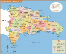
Map of the Dominican Republic highlights all major provinces, their boundaries, and important cities across the country. It clearly marks Santo Domingo, the national capital, along with other significant urban centers such as Santiago, La Romana, Puerto Plata, and San Pedro de Macorís. Major roads and river networks are shown to provide an accurate understanding of transportation routes and natural features. The map also outlines the country’s position next to Haiti and its extensive Caribbean coastline. Key geographic areas, including national parks and coastal regions, are labeled for added clarity. Designed for students, travelers, and researchers, this map offers a comprehensive visual guide to the Dominican Republic’s administrative divisions and landscape.
Frequently Asked Questions about the Dominican Republic
1. What is the capital of the Dominican Republic?
Santo Domingo is the capital and largest city of the Dominican Republic. Founded in 1498, it is the oldest continuously inhabited European settlement in the Americas and is known for its historic Colonial Zone.
2. Where is the Dominican Republic located?
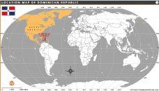
The Dominican Republic is located in the Caribbean on the island of Hispaniola. It shares the island with Haiti and is bordered by the Atlantic Ocean to the north and the Caribbean Sea to the south.
3. What is the official language of the Dominican Republic?
Spanish is the official language of the Dominican Republic. It is spoken throughout the country, while English is commonly understood in major tourist destinations.
4. What currency is used in the Dominican Republic?
The official currency is the Dominican Peso (DOP). Credit cards are widely accepted in cities and tourist areas, and ATMs are available throughout the country.
5. What is the Dominican Republic famous for?
The Dominican Republic is famous for its beautiful beaches, luxury resorts, tropical landscapes, baseball culture, merengue and bachata music, and historic landmarks in Santo Domingo.
6. What is the best time to visit the Dominican Republic?
The best time to visit is from December to April, when the weather is warm, sunny, and relatively dry, making it ideal for beach vacations and outdoor activities.
7. Is the Dominican Republic a good destination for tourists?
Yes, the Dominican Republic is one of the Caribbean's most popular tourist destinations. Visitors enjoy its white-sand beaches, national parks, water sports, cultural attractions, and year-round tropical climate.
- Afghanistan
- Albania
- Algeria
- Andorra
- Angola
- Antigua and Barbuda
- Argentina
- Armenia
- Australia
- Austria
- Azerbaijan
- Bahrain
- Bangladesh
- Barbados
- Belarus
- Belgium
- Belize
- Benin
- Bhutan
- Bolivia
- Bosnia and Herzegovina
- Botswana
- Brazil
- Brunei
- Bulgaria
- Burkina Faso
- Burma (Myanmar)
- Burundi
- Cabo Verde
- Cambodia
- Cameroon
- Canada
- Central African Republic
- Chad
- Chile
- China
- Colombia
- Comoros Islands
- Democratic Republic of the Congo
- Costa Rica
- Cote d'Ivoire
- Croatia
- Cuba
- Cyprus
- Czechia
- Denmark
- Djibouti
- Dominica
- Dominican Republic
- Ecuador
- Egypt
- El Salvador
- England
- Equatorial Guinea
- Eritrea
- Estonia
- eSwatini (formerly Swaziland)
- Ethiopia
- Federated States of Micronesia
- Fiji
- Finland
- France
- Gabon
- The Gambia
- Georgia
- Germany
- Ghana
- Greece
- Grenada
- Guatemala
- Guinea
- Guinea-Bissau
- Guyana
- Haiti
- Holy See
- Honduras
- Hungary
- Iceland
- India
- Indonesia
- Iran
- Iraq
- Ireland
- Israel
- Italy
- Jamaica
- Japan
- Jordan
- Kazakhstan
- Kenya
- Kiribati
- Kosovo
- Kuwait
- Kyrgyzstan
- Laos
- Latvia
- Lebanon
- Lesotho
- Liberia
- Libya
- Liechtenstein
- Lithuania
- Luxembourg
- Madagascar
- Malawi
- Malaysia
- Maldives
- Mali
- Malta
- Marshall Islands
- Mauritania
- Mauritius
- Mexico
- Moldova
- Monaco
- Mongolia
- Montenegro
- Morocco
- Mozambique
- Namibia
- Nauru
- Nepal
- Netherlands
- New Zealand
- Nicaragua
- Niger
- Nigeria
- North Korea
- Northern Ireland
- Norway
- Oman
- Pakistan
- Palau
- Panama
- Papua New Guinea
- Paraguay
- Peru
- Philippines
- Poland
- Portugal
- Puerto Rico (USA)
- Qatar
- North Macedonia
- Romania
- Russia
- Rwanda
- Saint Kitts and Nevis
- Saint Lucia
- Saint Vincent & the Grenadines
- Samoa
- San Marino
- Sao Tome and Principe
- Saudi Arabia
- Scotland
- Senegal
- Serbia
- Seychelles
- Sierra Leone
- Singapore
- Slovakia
- Slovenia
- Solomon Islands
- Somalia
- South Africa
- South Korea
- South Sudan
- Spain
- Sri Lanka
- Sudan
- Suriname
- Sweden
- Switzerland
- Syria
- Tajikistan
- Taiwan
- Tanzania
- Thailand
- The Bahamas
- Timor-Leste
- Togo
- Tonga
- Trinidad and Tobago
- Tunisia
- Turkey
- Turkmenistan
- Tuvalu
- Uganda
- Ukraine
- United Arab Emirates
- United Kingdom
- United States of America
- Uruguay
- Uzbekistan
- Vanuatu
- Western Sahara
- Venezuela
- Vietnam
- Wales
- Yemen
- Zambia
- Zimbabwe
