Belgium Map

About Belgium Map
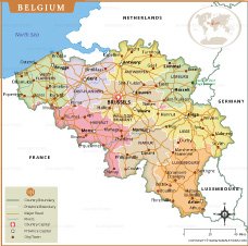
Map of Belgium depicts the country's provinces, major cities, and important transportation routes with clear geographic accuracy. Each province—such as East Flanders, Flemish Brabant, Hainaut, Limburg, and Luxembourg—is clearly color-coded, making regional divisions easy to understand. Major cities such as Brussels, Antwerp, Ghent, Liège, Bruges, and Namur are prominently marked, along with important roads connecting the country's urban centers.
The map also outlines Belgium's international borders with France, Germany, the Netherlands, and Luxembourg. Major rivers, including the Meuse and Scheldt, are shown flowing through the landscape, adding natural context to the region. This map serves as a useful reference for students, travelers, and researchers interested in Belgium's geography, transportation network, and administrative structure.
Frequently Asked Questions about the Belgium
1. Where is Belgium located?
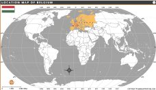
Belgium is a country in Western Europe, bordered by France, Germany, Luxembourg, and the Netherlands, with a coastline along the North Sea.
2. What is the capital of Belgium?
Brussels is the capital city of Belgium and also serves as the administrative center of the European Union.
3. What languages are spoken in Belgium?
Belgium has three official languages: Dutch (Flemish), French, and German.
4. What currency is used in Belgium?
The official languages of Belarus are Belarusian and Russian. Russian is more commonly spoken in daily life across the country.
5. What is Belgium famous for?
Belgium is known for its chocolates, waffles, fries, beer, medieval towns, and the headquarters of the European Union and NATO.
6. What is the population of Belgium?
Belgium has a population of approximately 11.8 million people, making it one of the most densely populated countries in Europe.
7. What are the major tourist attractions in Belgium?
Popular attractions include the Grand Place in Brussels, Atomium, Bruges' historic center, Ghent, Antwerp, and the Battle of Waterloo site.
- Afghanistan
- Albania
- Algeria
- Andorra
- Angola
- Antigua and Barbuda
- Argentina
- Armenia
- Australia
- Austria
- Azerbaijan
- Bahrain
- Bangladesh
- Barbados
- Belarus
- Belgium
- Belize
- Benin
- Bhutan
- Bolivia
- Bosnia and Herzegovina
- Botswana
- Brazil
- Brunei
- Bulgaria
- Burkina Faso
- Burma (Myanmar)
- Burundi
- Cabo Verde
- Cambodia
- Cameroon
- Canada
- Central African Republic
- Chad
- Chile
- China
- Colombia
- Comoros Islands
- Democratic Republic of the Congo
- Costa Rica
- Cote d'Ivoire
- Croatia
- Cuba
- Cyprus
- Czechia
- Denmark
- Djibouti
- Dominica
- Dominican Republic
- Ecuador
- Egypt
- El Salvador
- England
- Equatorial Guinea
- Eritrea
- Estonia
- eSwatini (formerly Swaziland)
- Ethiopia
- Federated States of Micronesia
- Fiji
- Finland
- France
- Gabon
- The Gambia
- Georgia
- Germany
- Ghana
- Greece
- Grenada
- Guatemala
- Guinea
- Guinea-Bissau
- Guyana
- Haiti
- Holy See
- Honduras
- Hungary
- Iceland
- India
- Indonesia
- Iran
- Iraq
- Ireland
- Israel
- Italy
- Jamaica
- Japan
- Jordan
- Kazakhstan
- Kenya
- Kiribati
- Kosovo
- Kuwait
- Kyrgyzstan
- Laos
- Latvia
- Lebanon
- Lesotho
- Liberia
- Libya
- Liechtenstein
- Lithuania
- Luxembourg
- Madagascar
- Malawi
- Malaysia
- Maldives
- Mali
- Malta
- Marshall Islands
- Mauritania
- Mauritius
- Mexico
- Moldova
- Monaco
- Mongolia
- Montenegro
- Morocco
- Mozambique
- Namibia
- Nauru
- Nepal
- Netherlands
- New Zealand
- Nicaragua
- Niger
- Nigeria
- North Korea
- Northern Ireland
- Norway
- Oman
- Pakistan
- Palau
- Panama
- Papua New Guinea
- Paraguay
- Peru
- Philippines
- Poland
- Portugal
- Puerto Rico (USA)
- Qatar
- North Macedonia
- Romania
- Russia
- Rwanda
- Saint Kitts and Nevis
- Saint Lucia
- Saint Vincent & the Grenadines
- Samoa
- San Marino
- Sao Tome and Principe
- Saudi Arabia
- Scotland
- Senegal
- Serbia
- Seychelles
- Sierra Leone
- Singapore
- Slovakia
- Slovenia
- Solomon Islands
- Somalia
- South Africa
- South Korea
- South Sudan
- Spain
- Sri Lanka
- Sudan
- Suriname
- Sweden
- Switzerland
- Syria
- Tajikistan
- Taiwan
- Tanzania
- Thailand
- The Bahamas
- Timor-Leste
- Togo
- Tonga
- Trinidad and Tobago
- Tunisia
- Turkey
- Turkmenistan
- Tuvalu
- Uganda
- Ukraine
- United Arab Emirates
- United Kingdom
- United States of America
- Uruguay
- Uzbekistan
- Vanuatu
- Western Sahara
- Venezuela
- Vietnam
- Wales
- Yemen
- Zambia
- Zimbabwe
