Costa Rica Map

About Costa Rica Map
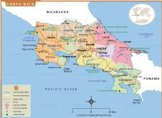
Map of Costa Rica shows the country’s provinces, capital cities, and major roads. Located in Central America, Costa Rica is bordered by Nicaragua to the north and Panama to the south, with coastlines on the Caribbean Sea and the Pacific Ocean. The map highlights key cities such as San José, the capital, along with Liberia, Limon, Cartago, and Puntarenas, providing a clear understanding of the nation’s political and geographical divisions.
Costa Rica is world-famous for its stunning biodiversity and eco-tourism attractions. The map marks important national parks like Corcovado, Tortuguero, Manuel Antonio, and Monteverde Cloud Forest Reserve, showcasing the country’s dedication to conservation. With lush rainforests, active volcanoes, and scenic beaches, Costa Rica offers a perfect mix of adventure and natural beauty, making it one of the most popular travel destinations in Central America.
Frequently Asked Questions about the Costa Rica
Where is Costa Rica located?
Costa Rica is located in Central America. It borders Nicaragua to the north, Panama to the southeast, the Caribbean Sea to the east, and the Pacific Ocean to the west.
2. What is the capital of Costa Rica?
The capital city of Costa Rica is San José, which is also the country's largest city and main cultural, political, and economic center.
3. What is Costa Rica famous for?
Costa Rica is known for its rich biodiversity, tropical rainforests, beautiful beaches, volcanoes, national parks, eco-tourism, and its decision to abolish its military in 1948.
4. What language is spoken in Costa Rica?
Spanish is the official language of Costa Rica. English is also widely spoken in many tourist destinations.
5. What currency is used in Costa Rica?
The official currency is the Costa Rican Colón (CRC). U.S. dollars are accepted at many hotels, restaurants, and tourist attractions.
6. What is the best time to visit Costa Rica?
Notable attractions include Manovo-Gounda St. Floris National Park, Dzanga-Sangha National Reserve, Andre Felix National Park, and the country's rich wildlife and tropical forests.
7. What is the Central African Republic known for?
The dry season, from December to April, is generally the best time to visit for sunny weather and outdoor activities. The green season (May to November) offers lush landscapes and fewer crowds.


- Afghanistan
- Albania
- Algeria
- Andorra
- Angola
- Antigua and Barbuda
- Argentina
- Armenia
- Australia
- Austria
- Azerbaijan
- Bahrain
- Bangladesh
- Barbados
- Belarus
- Belgium
- Belize
- Benin
- Bhutan
- Bolivia
- Bosnia and Herzegovina
- Botswana
- Brazil
- Brunei
- Bulgaria
- Burkina Faso
- Burma (Myanmar)
- Burundi
- Cabo Verde
- Cambodia
- Cameroon
- Canada
- Central African Republic
- Chad
- Chile
- China
- Colombia
- Comoros Islands
- Democratic Republic of the Congo
- Costa Rica
- Cote d'Ivoire
- Croatia
- Cuba
- Cyprus
- Czechia
- Denmark
- Djibouti
- Dominica
- Dominican Republic
- Ecuador
- Egypt
- El Salvador
- England
- Equatorial Guinea
- Eritrea
- Estonia
- eSwatini (formerly Swaziland)
- Ethiopia
- Federated States of Micronesia
- Fiji
- Finland
- France
- Gabon
- The Gambia
- Georgia
- Germany
- Ghana
- Greece
- Grenada
- Guatemala
- Guinea
- Guinea-Bissau
- Guyana
- Haiti
- Holy See
- Honduras
- Hungary
- Iceland
- India
- Indonesia
- Iran
- Iraq
- Ireland
- Israel
- Italy
- Jamaica
- Japan
- Jordan
- Kazakhstan
- Kenya
- Kiribati
- Kosovo
- Kuwait
- Kyrgyzstan
- Laos
- Latvia
- Lebanon
- Lesotho
- Liberia
- Libya
- Liechtenstein
- Lithuania
- Luxembourg
- Madagascar
- Malawi
- Malaysia
- Maldives
- Mali
- Malta
- Marshall Islands
- Mauritania
- Mauritius
- Mexico
- Moldova
- Monaco
- Mongolia
- Montenegro
- Morocco
- Mozambique
- Namibia
- Nauru
- Nepal
- Netherlands
- New Zealand
- Nicaragua
- Niger
- Nigeria
- North Korea
- Northern Ireland
- Norway
- Oman
- Pakistan
- Palau
- Panama
- Papua New Guinea
- Paraguay
- Peru
- Philippines
- Poland
- Portugal
- Puerto Rico (USA)
- Qatar
- North Macedonia
- Romania
- Russia
- Rwanda
- Saint Kitts and Nevis
- Saint Lucia
- Saint Vincent & the Grenadines
- Samoa
- San Marino
- Sao Tome and Principe
- Saudi Arabia
- Scotland
- Senegal
- Serbia
- Seychelles
- Sierra Leone
- Singapore
- Slovakia
- Slovenia
- Solomon Islands
- Somalia
- South Africa
- South Korea
- South Sudan
- Spain
- Sri Lanka
- Sudan
- Suriname
- Sweden
- Switzerland
- Syria
- Tajikistan
- Taiwan
- Tanzania
- Thailand
- The Bahamas
- Timor-Leste
- Togo
- Tonga
- Trinidad and Tobago
- Tunisia
- Turkey
- Turkmenistan
- Tuvalu
- Uganda
- Ukraine
- United Arab Emirates
- United Kingdom
- United States of America
- Uruguay
- Uzbekistan
- Vanuatu
- Western Sahara
- Venezuela
- Vietnam
- Wales
- Yemen
- Zambia
- Zimbabwe
