Egypt Map

About Egypt Map
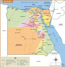
This map of Egypt displays the country’s governorates, capitals, major cities, and transport routes with precision and clarity. The map highlights key regions such as Cairo, Alexandria, Luxor, and Aswan, along with the boundaries separating each governorate. The Nile River, a lifeline of Egypt, flows prominently from south to north, supporting the country’s settlements and agriculture.
In addition to political divisions, the map also outlines neighboring countries including Libya, Sudan, Israel, and Palestine, as well as surrounding bodies of water like the Mediterranean Sea and the Red Sea. Major roads, rivers, and national parks such as Ras Muhammad National Park are clearly marked for reference. This comprehensive map is an ideal resource for travelers, students, and researchers seeking to understand Egypt’s geography, administrative divisions, and major landmarks. Perfect for educational or decorative purposes, it offers a visually engaging representation of Egypt’s diverse landscape and governance.
Frequently Asked Questions about the Egypt
1. What is the capital of Egypt?
Cairo is the capital and largest city of Egypt. It is the country's political, cultural, and economic center and is home to famous landmarks such as the Egyptian Museum and the nearby Giza Pyramids.
2. What is Egypt famous for?
Egypt is best known for its ancient civilization, including the Pyramids of Giza, the Great Sphinx, the Nile River, and the temples of Luxor and Karnak. It is also renowned for its rich history and archaeological treasures.
3. What is the official language of Egypt?
The official language of Egypt is Arabic, specifically Modern Standard Arabic for official purposes. Egyptian Arabic is the most widely spoken dialect in everyday life.
4. What currency is used in Egypt?
Egypt uses the Egyptian Pound (EGP) as its official currency. Banknotes and coins are widely accepted, and credit cards are commonly used in major cities and tourist areas.
5. Is Egypt a good destination for tourists?
Yes, Egypt is one of the world's most popular travel destinations. Visitors come to explore ancient monuments, cruise along the Nile River, relax at Red Sea resorts, and experience Egypt's unique culture and cuisine.
6. What is the best time to visit Egypt?
The best time to visit Egypt is from October to April, when temperatures are cooler and more comfortable for sightseeing, desert tours, and outdoor activities.
7. Where are the Pyramids of Giza located?
The Pyramids of Giza are located on the Giza Plateau, just southwest of Cairo. They include the Great Pyramid of Khufu, one of the Seven Wonders of the Ancient World, along with the pyramids of Khafre and Menkaure.
- Afghanistan
- Albania
- Algeria
- Andorra
- Angola
- Antigua and Barbuda
- Argentina
- Armenia
- Australia
- Austria
- Azerbaijan
- Bahrain
- Bangladesh
- Barbados
- Belarus
- Belgium
- Belize
- Benin
- Bhutan
- Bolivia
- Bosnia and Herzegovina
- Botswana
- Brazil
- Brunei
- Bulgaria
- Burkina Faso
- Burma (Myanmar)
- Burundi
- Cabo Verde
- Cambodia
- Cameroon
- Canada
- Central African Republic
- Chad
- Chile
- China
- Colombia
- Comoros Islands
- Democratic Republic of the Congo
- Costa Rica
- Cote d'Ivoire
- Croatia
- Cuba
- Cyprus
- Czechia
- Denmark
- Djibouti
- Dominica
- Dominican Republic
- Ecuador
- Egypt
- El Salvador
- England
- Equatorial Guinea
- Eritrea
- Estonia
- eSwatini (formerly Swaziland)
- Ethiopia
- Federated States of Micronesia
- Fiji
- Finland
- France
- Gabon
- The Gambia
- Georgia
- Germany
- Ghana
- Greece
- Grenada
- Guatemala
- Guinea
- Guinea-Bissau
- Guyana
- Haiti
- Holy See
- Honduras
- Hungary
- Iceland
- India
- Indonesia
- Iran
- Iraq
- Ireland
- Israel
- Italy
- Jamaica
- Japan
- Jordan
- Kazakhstan
- Kenya
- Kiribati
- Kosovo
- Kuwait
- Kyrgyzstan
- Laos
- Latvia
- Lebanon
- Lesotho
- Liberia
- Libya
- Liechtenstein
- Lithuania
- Luxembourg
- Madagascar
- Malawi
- Malaysia
- Maldives
- Mali
- Malta
- Marshall Islands
- Mauritania
- Mauritius
- Mexico
- Moldova
- Monaco
- Mongolia
- Montenegro
- Morocco
- Mozambique
- Namibia
- Nauru
- Nepal
- Netherlands
- New Zealand
- Nicaragua
- Niger
- Nigeria
- North Korea
- Northern Ireland
- Norway
- Oman
- Pakistan
- Palau
- Panama
- Papua New Guinea
- Paraguay
- Peru
- Philippines
- Poland
- Portugal
- Puerto Rico (USA)
- Qatar
- North Macedonia
- Romania
- Russia
- Rwanda
- Saint Kitts and Nevis
- Saint Lucia
- Saint Vincent & the Grenadines
- Samoa
- San Marino
- Sao Tome and Principe
- Saudi Arabia
- Scotland
- Senegal
- Serbia
- Seychelles
- Sierra Leone
- Singapore
- Slovakia
- Slovenia
- Solomon Islands
- Somalia
- South Africa
- South Korea
- South Sudan
- Spain
- Sri Lanka
- Sudan
- Suriname
- Sweden
- Switzerland
- Syria
- Tajikistan
- Taiwan
- Tanzania
- Thailand
- The Bahamas
- Timor-Leste
- Togo
- Tonga
- Trinidad and Tobago
- Tunisia
- Turkey
- Turkmenistan
- Tuvalu
- Uganda
- Ukraine
- United Arab Emirates
- United Kingdom
- United States of America
- Uruguay
- Uzbekistan
- Vanuatu
- Western Sahara
- Venezuela
- Vietnam
- Wales
- Yemen
- Zambia
- Zimbabwe
