ARUNACHAL PRADESH LOCATION MAP

About Arunachal Pradesh Location Map
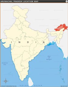
This Arunachal Pradesh location map shows the state's geographic location in India's northeastern region. Marked in red, Arunachal Pradesh shares international borders with Bhutan, China, and Myanmar, and domestic borders with Assam and Nagaland. This map clearly depicts its location relative to the rest of India, making it easier to understand its strategic importance and connectivity. It is an essential reference for students, researchers, and travelers exploring India's northeastern states.
Quick Facts About Arunachal Pradesh
| Fact | Detail |
|---|---|
| Country | India |
| Capital | Itanagar |
| Formation Date | 20 February 1987 |
| Official Languages | English (major spoken: Nyishi, Adi, Apatani, Monpa, Galo, Mishmi, etc.) |
| Area | 83,743 sq km |
| Population (2021 est.) | ~1.6 million |
| Literacy Rate | ~66.95% (2011 Census, projected ~70% in 2021) |
| State Animal | Mithun (Gayal) |
| State Bird | Great Hornbill |
| State Flower | Foxtail Orchid (Rhynchostylis retusa) |
| State Tree | Hollong (Dipterocarpus macrocarpus) |
| Major Rivers | Siang (Brahmaputra), Subansiri, Kameng, Lohit, Tirap, Dibang |
| No. of Districts | 26 (as of 2021; with new notifications possibly more) |
| Largest District (By Area) | Dibang Valley (~9,129 sq km) |
| Borders With | Assam, Nagaland, Bhutan, China (Tibet), Myanmar |
| Major Religion | Hinduism, Christianity, Buddhism, Indigenous faiths |
| Famous For | Scenic beauty, Tawang Monastery, tribal culture, orchids, biodiversity, adventure tourism, easternmost state of India |
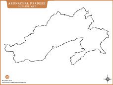
ARUNACHAL PRADESH MAPS

INDIA STATE MAPS


WORLD COUNTRIES
- Afghanistan
- Albania
- Algeria
- Andorra
- Angola
- Antigua and Barbuda
- Argentina
- Armenia
- Australia
- Austria
- Azerbaijan
- Bahrain
- Bangladesh
- Barbados
- Belarus
- Belgium
- Belize
- Benin
- Bhutan
- Bolivia
- Bosnia and Herzegovina
- Botswana
- Brazil
- Brunei
- Bulgaria
- Burkina Faso
- Burma (Myanmar)
- Burundi
- Cabo Verde
- Cambodia
- Cameroon
- Canada
- Central African Republic
- Chad
- Chile
- China
- Colombia
- Comoros Islands
- Democratic Republic of the Congo
- Costa Rica
- Cote d'Ivoire
- Croatia
- Cuba
- Cyprus
- Czechia
- Denmark
- Djibouti
- Dominica
- Dominican Republic
- Ecuador
- Egypt
- El Salvador
- England
- Equatorial Guinea
- Eritrea
- Estonia
- eSwatini (formerly Swaziland)
- Ethiopia
- Federated States of Micronesia
- Fiji
- Finland
- France
- Gabon
- The Gambia
- Georgia
- Germany
- Ghana
- Greece
- Grenada
- Guatemala
- Guinea
- Guinea-Bissau
- Guyana
- Haiti
- Holy See
- Honduras
- Hungary
- Iceland
- India
- Indonesia
- Iran
- Iraq
- Ireland
- Israel
- Italy
- Jamaica
- Japan
- Jordan
- Kazakhstan
- Kenya
- Kiribati
- Kosovo
- Kuwait
- Kyrgyzstan
- Laos
- Latvia
- Lebanon
- Lesotho
- Liberia
- Libya
- Liechtenstein
- Lithuania
- Luxembourg
- Madagascar
- Malawi
- Malaysia
- Maldives
- Mali
- Malta
- Marshall Islands
- Mauritania
- Mauritius
- Mexico
- Moldova
- Monaco
- Mongolia
- Montenegro
- Morocco
- Mozambique
- Namibia
- Nauru
- Nepal
- Netherlands
- New Zealand
- Nicaragua
- Niger
- Nigeria
- North Korea
- Northern Ireland
- Norway
- Oman
- Pakistan
- Palau
- Panama
- Papua New Guinea
- Paraguay
- Peru
- Philippines
- Poland
- Portugal
- Puerto Rico (USA)
- Qatar
- North Macedonia
- Romania
- Russia
- Rwanda
- Saint Kitts and Nevis
- Saint Lucia
- Saint Vincent & the Grenadines
- Samoa
- San Marino
- Sao Tome and Principe
- Saudi Arabia
- Scotland
- Senegal
- Serbia
- Seychelles
- Sierra Leone
- Singapore
- Slovakia
- Slovenia
- Solomon Islands
- Somalia
- South Africa
- South Korea
- South Sudan
- Spain
- Sri Lanka
- Sudan
- Suriname
- Sweden
- Switzerland
- Syria
- Tajikistan
- Taiwan
- Tanzania
- Thailand
- The Bahamas
- Timor-Leste
- Togo
- Tonga
- Trinidad and Tobago
- Tunisia
- Turkey
- Turkmenistan
- Tuvalu
- Uganda
- Ukraine
- United Arab Emirates
- United Kingdom
- United States of America
- Uruguay
- Uzbekistan
- Vanuatu
- Western Sahara
- Venezuela
- Vietnam
- Wales
- Yemen
- Zambia
- Zimbabwe
