Himachal Pradesh District Map

About Himachal Pradesh District Map
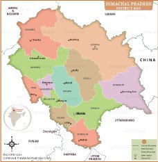
This Himachal Pradesh District Map shows all the major districts with clearly marked boundaries and headquarters. Important districts like Kangra, Chamba, Mandi, Kullu and Shimla are marked along with their administrative centres. The state capital Shimla is also prominently shown. This map shows the boundaries of Himachal Pradesh with Punjab, Haryana, Uttarakhand, Ladakh, Jammu and Kashmir and China. This district map is a useful guide for students, researchers and travellers to understand the administrative and geographical divisions of Himachal Pradesh.
Himachal Pradesh has a population of around 7.4 million (Census 2011). Kangra is the most populous district. The state has a literacy rate of over 82%, reflecting its emphasis on education. Agriculture, fruit production and tourism are the main sources of income. Himachal Pradesh is also known for its cultural mix, with both Hindu and Buddhist communities living here, making it rich in traditions and diversity.
List of Districts in Himachal Pradesh
| District | Headquarters | Area(km.²) | Population | Bilaspur | Bilaspur | 1167 | 381956 | Chamba | Chamba | 6528 | 519080 | Hamirpur | Hamirpur | 1118 | 454768 | Kangra | Dharamasala | 5739 | 1510075 | Kinnaur | Reckong Peo | 6401 | 84121 | Kulu | Kulu | 5503 | 437903 | Lahaul and Spiti | Keylong | 13835 | 31564 | Mandi | Mandi | 3950 | 999777 | Shimla | Shimla | 5131 | 814010 | Sirmaur | Nahan | 2825 | 529855 | Solan | Solan | 1936 | 580320 | Una | Una | 1540 | 521173 |
|---|


- Afghanistan
- Albania
- Algeria
- Andorra
- Angola
- Antigua and Barbuda
- Argentina
- Armenia
- Australia
- Austria
- Azerbaijan
- Bahrain
- Bangladesh
- Barbados
- Belarus
- Belgium
- Belize
- Benin
- Bhutan
- Bolivia
- Bosnia and Herzegovina
- Botswana
- Brazil
- Brunei
- Bulgaria
- Burkina Faso
- Burma (Myanmar)
- Burundi
- Cabo Verde
- Cambodia
- Cameroon
- Canada
- Central African Republic
- Chad
- Chile
- China
- Colombia
- Comoros Islands
- Democratic Republic of the Congo
- Costa Rica
- Cote d'Ivoire
- Croatia
- Cuba
- Cyprus
- Czechia
- Denmark
- Djibouti
- Dominica
- Dominican Republic
- Ecuador
- Egypt
- El Salvador
- England
- Equatorial Guinea
- Eritrea
- Estonia
- eSwatini (formerly Swaziland)
- Ethiopia
- Federated States of Micronesia
- Fiji
- Finland
- France
- Gabon
- The Gambia
- Georgia
- Germany
- Ghana
- Greece
- Grenada
- Guatemala
- Guinea
- Guinea-Bissau
- Guyana
- Haiti
- Holy See
- Honduras
- Hungary
- Iceland
- India
- Indonesia
- Iran
- Iraq
- Ireland
- Israel
- Italy
- Jamaica
- Japan
- Jordan
- Kazakhstan
- Kenya
- Kiribati
- Kosovo
- Kuwait
- Kyrgyzstan
- Laos
- Latvia
- Lebanon
- Lesotho
- Liberia
- Libya
- Liechtenstein
- Lithuania
- Luxembourg
- Madagascar
- Malawi
- Malaysia
- Maldives
- Mali
- Malta
- Marshall Islands
- Mauritania
- Mauritius
- Mexico
- Moldova
- Monaco
- Mongolia
- Montenegro
- Morocco
- Mozambique
- Namibia
- Nauru
- Nepal
- Netherlands
- New Zealand
- Nicaragua
- Niger
- Nigeria
- North Korea
- Northern Ireland
- Norway
- Oman
- Pakistan
- Palau
- Panama
- Papua New Guinea
- Paraguay
- Peru
- Philippines
- Poland
- Portugal
- Puerto Rico (USA)
- Qatar
- North Macedonia
- Romania
- Russia
- Rwanda
- Saint Kitts and Nevis
- Saint Lucia
- Saint Vincent & the Grenadines
- Samoa
- San Marino
- Sao Tome and Principe
- Saudi Arabia
- Scotland
- Senegal
- Serbia
- Seychelles
- Sierra Leone
- Singapore
- Slovakia
- Slovenia
- Solomon Islands
- Somalia
- South Africa
- South Korea
- South Sudan
- Spain
- Sri Lanka
- Sudan
- Suriname
- Sweden
- Switzerland
- Syria
- Tajikistan
- Taiwan
- Tanzania
- Thailand
- The Bahamas
- Timor-Leste
- Togo
- Tonga
- Trinidad and Tobago
- Tunisia
- Turkey
- Turkmenistan
- Tuvalu
- Uganda
- Ukraine
- United Arab Emirates
- United Kingdom
- United States of America
- Uruguay
- Uzbekistan
- Vanuatu
- Western Sahara
- Venezuela
- Vietnam
- Wales
- Yemen
- Zambia
- Zimbabwe
