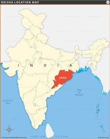
ODISHA LOCATION MAP

About Odisha Location Map
This Odisha location map highlights the eastern state of Odisha within India, showcasing its geographical position and boundaries. Assam, known for its natural beauty, architecture and rich cultural heritage, shares borders with several states and Andhra Pradehs, Chhattisgarh, Jharkhand and West Bengal. Positioned near the Bay of Bengal, the map provides clear visualization of Odisha’s location in India. It is an ideal reference for students, researchers, and travelers seeking accurate geographical and political context of Assam in India.
Quick Facts About Odisha
| Fact | Detail |
|---|---|
| Country | India |
| Capital | Bhubaneswar |
| Formation Date | 1 April 1936 (Utkal Divas) |
| Official Languages | Odia (primary), Hindi, English |
| Area | 155,707 sq km |
| Population (2021 est.) | ~46 million |
| Literacy Rate | 73.5% (2011 Census) |
| State Animal | Sambar Deer |
| State Bird | Indian Roller (Blue Jay) |
| State Flower | Ashoka Flower |
| State Tree | Ashwatha Tree (Sacred Fig) |
| Major Rivers | Mahanadi, Subarnarekha, Brahmani, Baitarani, Rushikulya, Indravati, Vansadhara, Nagavali |
| No. of Districts | 30 |
| Largest District (By Area) | Mayurbhanj (10,418 sq km) |
| Borders With | West Bengal, Jharkhand, Chhattisgarh, Andhra Pradesh |
| Major Religion | Hinduism (>93%) |
| Famous For | Jagannath Temple, Konark Sun Temple, Chilika Lake, Tribal Culture, Odissi Dance, Rath Yatra, Ancient Caves, Scenic Coast |

INDIA STATE MAPS


WORLD COUNTRIES
- Afghanistan
- Albania
- Algeria
- Andorra
- Angola
- Antigua and Barbuda
- Argentina
- Armenia
- Australia
- Austria
- Azerbaijan
- Bahrain
- Bangladesh
- Barbados
- Belarus
- Belgium
- Belize
- Benin
- Bhutan
- Bolivia
- Bosnia and Herzegovina
- Botswana
- Brazil
- Brunei
- Bulgaria
- Burkina Faso
- Burma (Myanmar)
- Burundi
- Cabo Verde
- Cambodia
- Cameroon
- Canada
- Central African Republic
- Chad
- Chile
- China
- Colombia
- Comoros Islands
- Democratic Republic of the Congo
- Costa Rica
- Cote d'Ivoire
- Croatia
- Cuba
- Cyprus
- Czechia
- Denmark
- Djibouti
- Dominica
- Dominican Republic
- Ecuador
- Egypt
- El Salvador
- England
- Equatorial Guinea
- Eritrea
- Estonia
- eSwatini (formerly Swaziland)
- Ethiopia
- Federated States of Micronesia
- Fiji
- Finland
- France
- Gabon
- The Gambia
- Georgia
- Germany
- Ghana
- Greece
- Grenada
- Guatemala
- Guinea
- Guinea-Bissau
- Guyana
- Haiti
- Holy See
- Honduras
- Hungary
- Iceland
- India
- Indonesia
- Iran
- Iraq
- Ireland
- Israel
- Italy
- Jamaica
- Japan
- Jordan
- Kazakhstan
- Kenya
- Kiribati
- Kosovo
- Kuwait
- Kyrgyzstan
- Laos
- Latvia
- Lebanon
- Lesotho
- Liberia
- Libya
- Liechtenstein
- Lithuania
- Luxembourg
- Madagascar
- Malawi
- Malaysia
- Maldives
- Mali
- Malta
- Marshall Islands
- Mauritania
- Mauritius
- Mexico
- Moldova
- Monaco
- Mongolia
- Montenegro
- Morocco
- Mozambique
- Namibia
- Nauru
- Nepal
- Netherlands
- New Zealand
- Nicaragua
- Niger
- Nigeria
- North Korea
- Northern Ireland
- Norway
- Oman
- Pakistan
- Palau
- Panama
- Papua New Guinea
- Paraguay
- Peru
- Philippines
- Poland
- Portugal
- Puerto Rico (USA)
- Qatar
- North Macedonia
- Romania
- Russia
- Rwanda
- Saint Kitts and Nevis
- Saint Lucia
- Saint Vincent & the Grenadines
- Samoa
- San Marino
- Sao Tome and Principe
- Saudi Arabia
- Scotland
- Senegal
- Serbia
- Seychelles
- Sierra Leone
- Singapore
- Slovakia
- Slovenia
- Solomon Islands
- Somalia
- South Africa
- South Korea
- South Sudan
- Spain
- Sri Lanka
- Sudan
- Suriname
- Sweden
- Switzerland
- Syria
- Tajikistan
- Taiwan
- Tanzania
- Thailand
- The Bahamas
- Timor-Leste
- Togo
- Tonga
- Trinidad and Tobago
- Tunisia
- Turkey
- Turkmenistan
- Tuvalu
- Uganda
- Ukraine
- United Arab Emirates
- United Kingdom
- United States of America
- Uruguay
- Uzbekistan
- Vanuatu
- Western Sahara
- Venezuela
- Vietnam
- Wales
- Yemen
- Zambia
- Zimbabwe
