Punjab District Map

About Punjab District Map
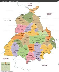
This detailed map of Punjab outlines all its districts with clear boundaries and color-coded regions. Ludhiana, the largest district in terms of population and economic activity, is centrally located and serves as a major industrial hub. Barnala, on the other hand, is one of the smallest districts in terms of both area and population. The map shows major cities like Amritsar, Patiala, and Jalandhar, as well as the state capital Chandigarh. Punjab has a population of over 27 million, with a higher urban concentration in districts like Ludhiana and Amritsar. The map shows major infrastructure such as national highways, major roads, and rivers including the Sutlej and Beas. It also shows Punjab's borders with Haryana, Himachal Pradesh, Rajasthan, and Pakistan.
List of Districts in Punjab
| District | Headquarters | Area(km.²) | Population | Amritsar | Amritsar | 2647 | 2490891 | Barnala | Barnala | 1410 | 596294 | Bathinda | Bathinda | 3385 | 1388859 | Faridkot | Faridkot | 1469 | 618008 | Fatehgarh Sahib | Fatehgarh Sahib | 1180 | 599814 | Firozpur | Firozpur | 2190 | 965337 | Fazilka[4] | Fazilka | 3113 | 1180483 | Gurdaspur | Gurdaspur | 2635 | 2299026 | Hoshiarpur | Hoshiarpur | 3365 | 1582793 | Jalandhar | Jalandhar | 2632 | 2181753 | Kapurthala | Kapurthala | 1632 | 817668 | Ludhiana | Ludhiana | 3767 | 3487882 | Malerkotla | Malerkotla | 837 | 452016 | Mansa | Mansa | 2171 | 768808 | Moga | Moga | 2216 | 992289 | Sri Muktsar Sahib | Sri Muktsar Sahib | 2615 | 902702 | Pathankot | Pathankot | 929 | 676598 | Patiala | Patiala | 3218 | 1892282 | Rupnagar | Rupnagar | 1369 | 683349 | Sahibzada Ajit Singh Nagar | Mohali | 1093 | 986147 | Sangrur | Sangrur | 2848 | 1203153 | Shahid Bhagat Singh Nagar | Nawanshahr | 1267 | 614362 | Tarn Taran | Tarn Taran Sahib | 2449 | 1120070 |
|---|


- Afghanistan
- Albania
- Algeria
- Andorra
- Angola
- Antigua and Barbuda
- Argentina
- Armenia
- Australia
- Austria
- Azerbaijan
- Bahrain
- Bangladesh
- Barbados
- Belarus
- Belgium
- Belize
- Benin
- Bhutan
- Bolivia
- Bosnia and Herzegovina
- Botswana
- Brazil
- Brunei
- Bulgaria
- Burkina Faso
- Burma (Myanmar)
- Burundi
- Cabo Verde
- Cambodia
- Cameroon
- Canada
- Central African Republic
- Chad
- Chile
- China
- Colombia
- Comoros Islands
- Democratic Republic of the Congo
- Costa Rica
- Cote d'Ivoire
- Croatia
- Cuba
- Cyprus
- Czechia
- Denmark
- Djibouti
- Dominica
- Dominican Republic
- Ecuador
- Egypt
- El Salvador
- England
- Equatorial Guinea
- Eritrea
- Estonia
- eSwatini (formerly Swaziland)
- Ethiopia
- Federated States of Micronesia
- Fiji
- Finland
- France
- Gabon
- The Gambia
- Georgia
- Germany
- Ghana
- Greece
- Grenada
- Guatemala
- Guinea
- Guinea-Bissau
- Guyana
- Haiti
- Holy See
- Honduras
- Hungary
- Iceland
- India
- Indonesia
- Iran
- Iraq
- Ireland
- Israel
- Italy
- Jamaica
- Japan
- Jordan
- Kazakhstan
- Kenya
- Kiribati
- Kosovo
- Kuwait
- Kyrgyzstan
- Laos
- Latvia
- Lebanon
- Lesotho
- Liberia
- Libya
- Liechtenstein
- Lithuania
- Luxembourg
- Madagascar
- Malawi
- Malaysia
- Maldives
- Mali
- Malta
- Marshall Islands
- Mauritania
- Mauritius
- Mexico
- Moldova
- Monaco
- Mongolia
- Montenegro
- Morocco
- Mozambique
- Namibia
- Nauru
- Nepal
- Netherlands
- New Zealand
- Nicaragua
- Niger
- Nigeria
- North Korea
- Northern Ireland
- Norway
- Oman
- Pakistan
- Palau
- Panama
- Papua New Guinea
- Paraguay
- Peru
- Philippines
- Poland
- Portugal
- Puerto Rico (USA)
- Qatar
- North Macedonia
- Romania
- Russia
- Rwanda
- Saint Kitts and Nevis
- Saint Lucia
- Saint Vincent & the Grenadines
- Samoa
- San Marino
- Sao Tome and Principe
- Saudi Arabia
- Scotland
- Senegal
- Serbia
- Seychelles
- Sierra Leone
- Singapore
- Slovakia
- Slovenia
- Solomon Islands
- Somalia
- South Africa
- South Korea
- South Sudan
- Spain
- Sri Lanka
- Sudan
- Suriname
- Sweden
- Switzerland
- Syria
- Tajikistan
- Taiwan
- Tanzania
- Thailand
- The Bahamas
- Timor-Leste
- Togo
- Tonga
- Trinidad and Tobago
- Tunisia
- Turkey
- Turkmenistan
- Tuvalu
- Uganda
- Ukraine
- United Arab Emirates
- United Kingdom
- United States of America
- Uruguay
- Uzbekistan
- Vanuatu
- Western Sahara
- Venezuela
- Vietnam
- Wales
- Yemen
- Zambia
- Zimbabwe
