Northern Ireland Map

About Northern Ireland Map
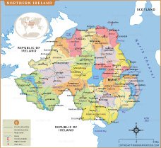
This detailed Northern Ireland map highlights administrative districts, major towns, cities, rivers, and important transportation routes across the region. The map clearly displays district boundaries including Belfast, Derry, Antrim, Armagh, Down, and Fermanagh, helping users understand the political and geographic layout of Northern Ireland. Coastal features, lakes, and neighboring regions such as the Republic of Ireland and Scotland are also illustrated for better regional context.
This detailed Northern Ireland map highlights administrative districts, major towns, cities, rivers, and important transportation routes across the region. The map clearly displays district boundaries including Belfast, Derry, Antrim, Armagh, Down, and Fermanagh, helping users understand the political and geographic layout of Northern Ireland. Coastal features, lakes, and neighboring regions such as the Republic of Ireland and Scotland are also illustrated for better regional context.
Frequently Asked Questions about the Northern Ireland
1. What is Northern Ireland famous for?
Northern Ireland is famous for the Giant’s Causeway, scenic coastlines, historic castles, Titanic Belfast, and beautiful natural landscapes.
2. What is the capital of Northern Ireland?
Belfast is the capital and largest city of Northern Ireland, known for its history, culture, and shipbuilding heritage.
3. Is Northern Ireland part of the United Kingdom?
Yes, Northern Ireland is one of the four countries that make up the United Kingdom along with England, Scotland, and Wales.
4. What currency is used in Northern Ireland?
Northern Ireland uses the British Pound Sterling (£) as its official currency.
5. What are the major tourist attractions in Northern Ireland?
Popular attractions include Giant’s Causeway, Titanic Belfast, Carrick-a-Rede Rope Bridge, Dark Hedges, and Mourne Mountains.
6. What language is spoken in Northern Ireland?
English is the primary language spoken in Northern Ireland, while Irish and Ulster Scots are also recognized regional languages.
7. What is the best time to visit Northern Ireland?
The best time to visit Northern Ireland is between May and September when the weather is pleasant and outdoor attractions are most enjoyable.
- Afghanistan
- Albania
- Algeria
- Andorra
- Angola
- Antigua and Barbuda
- Argentina
- Armenia
- Australia
- Austria
- Azerbaijan
- Bahrain
- Bangladesh
- Barbados
- Belarus
- Belgium
- Belize
- Benin
- Bhutan
- Bolivia
- Bosnia and Herzegovina
- Botswana
- Brazil
- Brunei
- Bulgaria
- Burkina Faso
- Burma (Myanmar)
- Burundi
- Cabo Verde
- Cambodia
- Cameroon
- Canada
- Central African Republic
- Chad
- Chile
- China
- Colombia
- Comoros Islands
- Democratic Republic of the Congo
- Costa Rica
- Cote d'Ivoire
- Croatia
- Cuba
- Cyprus
- Czechia
- Denmark
- Djibouti
- Dominica
- Dominican Republic
- Ecuador
- Egypt
- El Salvador
- England
- Equatorial Guinea
- Eritrea
- Estonia
- eSwatini (formerly Swaziland)
- Ethiopia
- Federated States of Micronesia
- Fiji
- Finland
- France
- Gabon
- The Gambia
- Georgia
- Germany
- Ghana
- Greece
- Grenada
- Guatemala
- Guinea
- Guinea-Bissau
- Guyana
- Haiti
- Holy See
- Honduras
- Hungary
- Iceland
- India
- Indonesia
- Iran
- Iraq
- Ireland
- Israel
- Italy
- Jamaica
- Japan
- Jordan
- Kazakhstan
- Kenya
- Kiribati
- Kosovo
- Kuwait
- Kyrgyzstan
- Laos
- Latvia
- Lebanon
- Lesotho
- Liberia
- Libya
- Liechtenstein
- Lithuania
- Luxembourg
- Madagascar
- Malawi
- Malaysia
- Maldives
- Mali
- Malta
- Marshall Islands
- Mauritania
- Mauritius
- Mexico
- Moldova
- Monaco
- Mongolia
- Montenegro
- Morocco
- Mozambique
- Namibia
- Nauru
- Nepal
- Netherlands
- New Zealand
- Nicaragua
- Niger
- Nigeria
- North Korea
- Northern Ireland
- Norway
- Oman
- Pakistan
- Palau
- Panama
- Papua New Guinea
- Paraguay
- Peru
- Philippines
- Poland
- Portugal
- Puerto Rico (USA)
- Qatar
- North Macedonia
- Romania
- Russia
- Rwanda
- Saint Kitts and Nevis
- Saint Lucia
- Saint Vincent & the Grenadines
- Samoa
- San Marino
- Sao Tome and Principe
- Saudi Arabia
- Scotland
- Senegal
- Serbia
- Seychelles
- Sierra Leone
- Singapore
- Slovakia
- Slovenia
- Solomon Islands
- Somalia
- South Africa
- South Korea
- South Sudan
- Spain
- Sri Lanka
- Sudan
- Suriname
- Sweden
- Switzerland
- Syria
- Tajikistan
- Taiwan
- Tanzania
- Thailand
- The Bahamas
- Timor-Leste
- Togo
- Tonga
- Trinidad and Tobago
- Tunisia
- Turkey
- Turkmenistan
- Tuvalu
- Uganda
- Ukraine
- United Arab Emirates
- United Kingdom
- United States of America
- Uruguay
- Uzbekistan
- Vanuatu
- Western Sahara
- Venezuela
- Vietnam
- Wales
- Yemen
- Zambia
- Zimbabwe