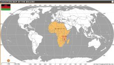
Where is Malawi?

where-is-malawi

Location map of Malawi highlighting its position in southeastern Africa on the world map.​

Size: 24"x30" (WxH) inches

Resolution: 150 Dpi JPG

About Where is Malawi

This location map highlights Malawi on the world map, showing its position in southeastern Africa. The country is displayed within the African continent to provide clear geographic context. Malawi lies between Tanzania, Mozambique, and Zambia. The map helps viewers easily understand Malawi’s global and regional location, making it useful for education, research, and general geographic reference.

Quick Facts About Malawi

MALAWI MAPS

Map of malawi
Malawi Map
Malawi Outline Map
Malawi Outline Map
Malawi Flag Map Thumb
Malawi Flag Map
Where is Malawi
Where is Malawi?
WORLD COUNTRIES

FactDetails
Official NameRepublic of The Gambia
Capital CityBanjul
Largest CitySerekunda
GovernmentUnitary presidential republic
Official LanguageEnglish
Population~2.7 million (approx.)
Official ReligionIslam (majority religion)
CurrencyGambian Dalasi
Area11,295 km²
Major RiversGambia River
Highest PeakRed Rock (approx. 53 m)
Time ZoneGreenwich Mean Time (GMT, UTC+0)
Calling Code+220
Internet TLD.gm
Drives onRight