South Australia Map

About South Australia Map
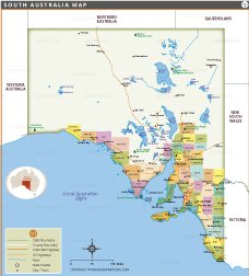
This detailed South Australia map highlights major cities, towns, highways, rivers, national parks, and administrative boundaries across the state. It clearly shows connections to Western Australia, Northern Territory, Queensland, New South Wales, and Victoria. Coastal features along the Great Australian Bight, inland lakes, transport routes, and regional divisions are well defined. Ideal for geography learning, travel planning, educational use, and reference, this map provides a comprehensive visual overview of South Australia’s landscape and infrastructure.
SOUTH AUSTRALIA MAPS
Australia States and Territories
WORLD COUNTRIES
- Afghanistan
- Albania
- Algeria
- Andorra
- Angola
- Antigua and Barbuda
- Argentina
- Armenia
- Australia
- Austria
- Azerbaijan
- Bahrain
- Bangladesh
- Barbados
- Belarus
- Belgium
- Belize
- Benin
- Bhutan
- Bolivia
- Bosnia and Herzegovina
- Botswana
- Brazil
- Brunei
- Bulgaria
- Burkina Faso
- Burma (Myanmar)
- Burundi
- Cabo Verde
- Cambodia
- Cameroon
- Canada
- Central African Republic
- Chad
- Chile
- China
- Colombia
- Comoros Islands
- Democratic Republic of the Congo
- Costa Rica
- Cote d'Ivoire
- Croatia
- Cuba
- Cyprus
- Czechia
- Denmark
- Djibouti
- Dominica
- Dominican Republic
- Ecuador
- Egypt
- El Salvador
- England
- Equatorial Guinea
- Eritrea
- Estonia
- eSwatini (formerly Swaziland)
- Ethiopia
- Federated States of Micronesia
- Fiji
- Finland
- France
- Gabon
- The Gambia
- Georgia
- Germany
- Ghana
- Greece
- Grenada
- Guatemala
- Guinea
- Guinea-Bissau
- Guyana
- Haiti
- Holy See
- Honduras
- Hungary
- Iceland
- India
- Indonesia
- Iran
- Iraq
- Ireland
- Israel
- Italy
- Jamaica
- Japan
- Jordan
- Kazakhstan
- Kenya
- Kiribati
- Kosovo
- Kuwait
- Kyrgyzstan
- Laos
- Latvia
- Lebanon
- Lesotho
- Liberia
- Libya
- Liechtenstein
- Lithuania
- Luxembourg
- Madagascar
- Malawi
- Malaysia
- Maldives
- Mali
- Malta
- Marshall Islands
- Mauritania
- Mauritius
- Mexico
- Moldova
- Monaco
- Mongolia
- Montenegro
- Morocco
- Mozambique
- Namibia
- Nauru
- Nepal
- Netherlands
- New Zealand
- Nicaragua
- Niger
- Nigeria
- North Korea
- Northern Ireland
- Norway
- Oman
- Pakistan
- Palau
- Panama
- Papua New Guinea
- Paraguay
- Peru
- Philippines
- Poland
- Portugal
- Puerto Rico (USA)
- Qatar
- North Macedonia
- Romania
- Russia
- Rwanda
- Saint Kitts and Nevis
- Saint Lucia
- Saint Vincent & the Grenadines
- Samoa
- San Marino
- Sao Tome and Principe
- Saudi Arabia
- Scotland
- Senegal
- Serbia
- Seychelles
- Sierra Leone
- Singapore
- Slovakia
- Slovenia
- Solomon Islands
- Somalia
- South Africa
- South Korea
- South Sudan
- Spain
- Sri Lanka
- Sudan
- Suriname
- Sweden
- Switzerland
- Syria
- Tajikistan
- Taiwan
- Tanzania
- Thailand
- The Bahamas
- Timor-Leste
- Togo
- Tonga
- Trinidad and Tobago
- Tunisia
- Turkey
- Turkmenistan
- Tuvalu
- Uganda
- Ukraine
- United Arab Emirates
- United Kingdom
- United States of America
- Uruguay
- Uzbekistan
- Vanuatu
- Western Sahara
- Venezuela
- Vietnam
- Wales
- Yemen
- Zambia
- Zimbabwe
