Andhra Pradesh District Map

About Andhra Pradesh District Map
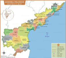
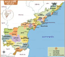
Andhra Pradesh district map shows the administrative boundaries and major locations across the state. It clearly shows the state capital Amaravati as well as all district headquarters and major towns. This map also shows important geographical divisions, making it useful for students, researchers and travelers. With different colors for each district, it provides a simple and clear understanding of the administrative set-up and regional distribution of Andhra Pradesh. This map is ideal for educational, planning and reference purposes.
List of Districts in Andhra Pradesh
| District | Headquarters | Area(km.²) | Population |
|---|---|---|---|
| Srikakulam | Srikakulam | 4591 | 2191471 |
| Parvathipuram Manyam | Parvathipuram | 3659 | 925340 |
| Vizianagaram | Vizianagaram | 4122 | 1930811 |
| Visakhapatnam | Visakhapatnam | 1048 | 1959544 |
| Alluri Sitharama Raju | Paderu | 12251 | 953960 |
| Anakapalli | Anakapalli | 4292 | 1726998 |
| Kakinada | Kakinada | 3019 | 2092374 |
| East Godavari | Rajamahendravaram | 2561 | 1832332 |
| Dr. B. R. Ambedkar Konaseema | Amalapuram | 2083 | 1719093 |
| Eluru | Eluru | 6579 | 2006737 |
| West Godavari | Bhimavaram | 2278 | 1844898 |
| NTR | Vijayawada | 3316 | 2218591 |
| Krishna | Machilipatnam | 3775 | 1735079 |
| Palnadu | Narasaraopeta | 7298 | 2041723 |
| Guntur | Guntur | 2443 | 2091075 |
| Bapatla | Bapatla | 3829 | 1586918 |
| Prakasam | Ongole | 14322 | 2288026 |
| Sri Potti Sriramulu Nellore | Nellore | 10441 | 2469712 |
| Kurnool | Kurnool | 7980 | 2271686 |
| Nandyal | Nandyal | 9682 | 1781777 |
| Anantapuramu | Anantapuramu | 10205 | 2241105 |
| Sri Sathya Sai | Puttaparthi | 8925 | 1840043 |
| YSR Kadapa | Kadapa | 11228 | 2060654 |
| Annamayya | Rayachoti | 7954 | 1697308 |
| Tirupati | Tirupati | 8231 | 2196984 |
| Chittoor | Chittoor | 6855 | 1872951 |
ANDHRA PRADESH MAPS

INDIA STATE MAPS


WORLD COUNTRIES
- Afghanistan
- Albania
- Algeria
- Andorra
- Angola
- Antigua and Barbuda
- Argentina
- Armenia
- Australia
- Austria
- Azerbaijan
- Bahrain
- Bangladesh
- Barbados
- Belarus
- Belgium
- Belize
- Benin
- Bhutan
- Bolivia
- Bosnia and Herzegovina
- Botswana
- Brazil
- Brunei
- Bulgaria
- Burkina Faso
- Burma (Myanmar)
- Burundi
- Cabo Verde
- Cambodia
- Cameroon
- Canada
- Central African Republic
- Chad
- Chile
- China
- Colombia
- Comoros Islands
- Democratic Republic of the Congo
- Costa Rica
- Cote d'Ivoire
- Croatia
- Cuba
- Cyprus
- Czechia
- Denmark
- Djibouti
- Dominica
- Dominican Republic
- Ecuador
- Egypt
- El Salvador
- England
- Equatorial Guinea
- Eritrea
- Estonia
- eSwatini (formerly Swaziland)
- Ethiopia
- Federated States of Micronesia
- Fiji
- Finland
- France
- Gabon
- The Gambia
- Georgia
- Germany
- Ghana
- Greece
- Grenada
- Guatemala
- Guinea
- Guinea-Bissau
- Guyana
- Haiti
- Holy See
- Honduras
- Hungary
- Iceland
- India
- Indonesia
- Iran
- Iraq
- Ireland
- Israel
- Italy
- Jamaica
- Japan
- Jordan
- Kazakhstan
- Kenya
- Kiribati
- Kosovo
- Kuwait
- Kyrgyzstan
- Laos
- Latvia
- Lebanon
- Lesotho
- Liberia
- Libya
- Liechtenstein
- Lithuania
- Luxembourg
- Madagascar
- Malawi
- Malaysia
- Maldives
- Mali
- Malta
- Marshall Islands
- Mauritania
- Mauritius
- Mexico
- Moldova
- Monaco
- Mongolia
- Montenegro
- Morocco
- Mozambique
- Namibia
- Nauru
- Nepal
- Netherlands
- New Zealand
- Nicaragua
- Niger
- Nigeria
- North Korea
- Northern Ireland
- Norway
- Oman
- Pakistan
- Palau
- Panama
- Papua New Guinea
- Paraguay
- Peru
- Philippines
- Poland
- Portugal
- Puerto Rico (USA)
- Qatar
- North Macedonia
- Romania
- Russia
- Rwanda
- Saint Kitts and Nevis
- Saint Lucia
- Saint Vincent & the Grenadines
- Samoa
- San Marino
- Sao Tome and Principe
- Saudi Arabia
- Scotland
- Senegal
- Serbia
- Seychelles
- Sierra Leone
- Singapore
- Slovakia
- Slovenia
- Solomon Islands
- Somalia
- South Africa
- South Korea
- South Sudan
- Spain
- Sri Lanka
- Sudan
- Suriname
- Sweden
- Switzerland
- Syria
- Tajikistan
- Taiwan
- Tanzania
- Thailand
- The Bahamas
- Timor-Leste
- Togo
- Tonga
- Trinidad and Tobago
- Tunisia
- Turkey
- Turkmenistan
- Tuvalu
- Uganda
- Ukraine
- United Arab Emirates
- United Kingdom
- United States of America
- Uruguay
- Uzbekistan
- Vanuatu
- Western Sahara
- Venezuela
- Vietnam
- Wales
- Yemen
- Zambia
- Zimbabwe
