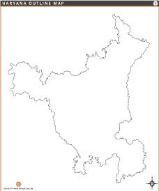
Haryana District Map

About Haryana District Map
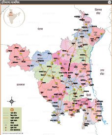
This detailed political map of Haryana shows all its districts with clear boundaries and district headquarters. Major districts like Gurgaon, Faridabad, Hisar, Rohtak and Karnal are clearly marked, as well as the state capital Chandigarh. The map also shows Haryana's neighboring states—Punjab, Himachal Pradesh, Uttar Pradesh, Rajasthan and Delhi. Useful for educational, administrative and travel purposes, this map provides a comprehensive view of Haryana's geography, administrative divisions and connectivity with surrounding regions of North India.
List of Districts in Haryana
| District | Headquarters | Area(km.²) | Population | Ambala | Ambala | 1569 | 1128350 | Bhiwani | Bhiwani | 5140 | 1634445 | Faridabad | Faridabad | 2105 | 1809733 | Fatehabad | Fatehabad | 2491 | 942011 | Gurgaon | Gurgaon | 2760 | 1514432 | Hissar | Hissar | 3788 | 1743931 | Jhajjar | Jhajjar | 1868 | 958405 | Jind | Jind | 2736 | 1334152 | Kaithal | Kaithal | 2799 | 1074304 | Karnal | Karnal | 2471 | 1505324 | Kurukshetra | Kurukshetra | 1217 | 964655 | Mahendragarh | Narnaul | 1683 | 922088 | Mewat | Gurgaon | 2760 | 1089263 | Palwal | Faridabad | 2105 | 1042708 | Panchkula | Panchkula | 816 | 561293 | Panipat | Panipat | 1250 | 1205437 | Rewari | Rewari | 1559 | 900332 | Rohtak | Rohtak | 1668 | 1061204 | Sirsa | Sirsa | 4276 | 1295189 | Sonepat | Sonepat | 2260 | 1450001 | Yamuna Nagar | Yamuna Nagar | 1756 | 1214205 |
|---|


INDIA STATE MAPS


WORLD COUNTRIES
- Afghanistan
- Albania
- Algeria
- Andorra
- Angola
- Antigua and Barbuda
- Argentina
- Armenia
- Australia
- Austria
- Azerbaijan
- Bahrain
- Bangladesh
- Barbados
- Belarus
- Belgium
- Belize
- Benin
- Bhutan
- Bolivia
- Bosnia and Herzegovina
- Botswana
- Brazil
- Brunei
- Bulgaria
- Burkina Faso
- Burma (Myanmar)
- Burundi
- Cabo Verde
- Cambodia
- Cameroon
- Canada
- Central African Republic
- Chad
- Chile
- China
- Colombia
- Comoros Islands
- Democratic Republic of the Congo
- Costa Rica
- Cote d'Ivoire
- Croatia
- Cuba
- Cyprus
- Czechia
- Denmark
- Djibouti
- Dominica
- Dominican Republic
- Ecuador
- Egypt
- El Salvador
- England
- Equatorial Guinea
- Eritrea
- Estonia
- eSwatini (formerly Swaziland)
- Ethiopia
- Federated States of Micronesia
- Fiji
- Finland
- France
- Gabon
- The Gambia
- Georgia
- Germany
- Ghana
- Greece
- Grenada
- Guatemala
- Guinea
- Guinea-Bissau
- Guyana
- Haiti
- Holy See
- Honduras
- Hungary
- Iceland
- India
- Indonesia
- Iran
- Iraq
- Ireland
- Israel
- Italy
- Jamaica
- Japan
- Jordan
- Kazakhstan
- Kenya
- Kiribati
- Kosovo
- Kuwait
- Kyrgyzstan
- Laos
- Latvia
- Lebanon
- Lesotho
- Liberia
- Libya
- Liechtenstein
- Lithuania
- Luxembourg
- Madagascar
- Malawi
- Malaysia
- Maldives
- Mali
- Malta
- Marshall Islands
- Mauritania
- Mauritius
- Mexico
- Moldova
- Monaco
- Mongolia
- Montenegro
- Morocco
- Mozambique
- Namibia
- Nauru
- Nepal
- Netherlands
- New Zealand
- Nicaragua
- Niger
- Nigeria
- North Korea
- Northern Ireland
- Norway
- Oman
- Pakistan
- Palau
- Panama
- Papua New Guinea
- Paraguay
- Peru
- Philippines
- Poland
- Portugal
- Puerto Rico (USA)
- Qatar
- North Macedonia
- Romania
- Russia
- Rwanda
- Saint Kitts and Nevis
- Saint Lucia
- Saint Vincent & the Grenadines
- Samoa
- San Marino
- Sao Tome and Principe
- Saudi Arabia
- Scotland
- Senegal
- Serbia
- Seychelles
- Sierra Leone
- Singapore
- Slovakia
- Slovenia
- Solomon Islands
- Somalia
- South Africa
- South Korea
- South Sudan
- Spain
- Sri Lanka
- Sudan
- Suriname
- Sweden
- Switzerland
- Syria
- Tajikistan
- Taiwan
- Tanzania
- Thailand
- The Bahamas
- Timor-Leste
- Togo
- Tonga
- Trinidad and Tobago
- Tunisia
- Turkey
- Turkmenistan
- Tuvalu
- Uganda
- Ukraine
- United Arab Emirates
- United Kingdom
- United States of America
- Uruguay
- Uzbekistan
- Vanuatu
- Western Sahara
- Venezuela
- Vietnam
- Wales
- Yemen
- Zambia
- Zimbabwe
