Rajasthan District Map

About Rajasthan District Map
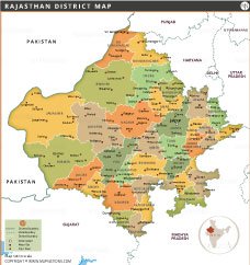
TThis Rajasthan district map displays all 33 districts with distinct colors and clear labels, helping users easily identify each area. District numbers can be added for quick reference. The map depicts major cities and towns, with clear boundaries to neighboring states and Pakistan. Jaisalmer is the largest district by area, while Dholpur is one of the smallest. Major districts such as Jaipur, Jodhpur, and Udaipur are prominently marked. Useful for students, researchers, tourists, and planners, this map combines administrative clarity with geographic accuracy, making it an excellent tool for education, travel, or state-level demographic analysis.
List of Districts in Rajasthan
| District | Headquarters | Area(km.²) | Population | Ajmer | Ajmer | 8481 | 2583052 | Alwar | Alwar | 8380 | 3674179 | Banswara | Banswara | 5037 | 1797485 | Baran | Baran | 6955 | 1222755 | Barmer | Barmer | 28387 | 2603751 | Bharatpur | Bharatpur | 5066 | 2548462 | Bhilwara | Bhilwara | 10455 | 2408523 | Bikaner | Bikaner | 27244 | 2363937 | Bundi | Bundi | 5550 | 1110906 | Chittorgarh | Chittorgarh | 10856 | 1544338 | Churu | Churu | 16830 | 2039547 | Dausa | Dausa | 3429 | 1634409 | Dholpur | Dholpur | 3084 | 1206516 | Dungarpur | Dungarpur | 3770 | 1388552 | Ganganagar | Ganganagar | 7984 | 1969168 | Hanumangarh | Hanumangarh | 12645 | 1774692 | Jaipur | Jaipur | 11152 | 6626178 | Jaisalmer | Jaisalmer | 38401 | 669919 | Jalore | Jalore | 10640 | 1828730 | Jhalawar | Jhalawar | 6219 | 1411129 | Jhunjhunun | Jhunjhunun | 5928 | 2137045 | Jodhpur | Jodhpur | 22850 | 3687165 | Karauli | Karauli | 5530 | 1458248 | Kota | Kota | 5446 | 1951014 | Nagaur | Nagaur | 17718 | 3307743 | Pali | Pali | 12387 | 2037573 | Pratapgarh | Pratapgarh | 4112 | 867848 | Rajsamand | Rajsamand | 3853 | 1156597 | Sawai Madhopur | Sawai Madhopur | 4500 | 1335551 | Sikar | Sikar | 7732 | 2677333 | Sirohi | Sirohi | 5136 | 1036346 | Tonk | Tonk | 7194 | 1421326 | Udaipur | Udaipur | 13430 | 3068420 |
|---|


INDIA STATE MAPS


WORLD COUNTRIES
- Afghanistan
- Albania
- Algeria
- Andorra
- Angola
- Antigua and Barbuda
- Argentina
- Armenia
- Australia
- Austria
- Azerbaijan
- Bahrain
- Bangladesh
- Barbados
- Belarus
- Belgium
- Belize
- Benin
- Bhutan
- Bolivia
- Bosnia and Herzegovina
- Botswana
- Brazil
- Brunei
- Bulgaria
- Burkina Faso
- Burma (Myanmar)
- Burundi
- Cabo Verde
- Cambodia
- Cameroon
- Canada
- Central African Republic
- Chad
- Chile
- China
- Colombia
- Comoros Islands
- Democratic Republic of the Congo
- Costa Rica
- Cote d'Ivoire
- Croatia
- Cuba
- Cyprus
- Czechia
- Denmark
- Djibouti
- Dominica
- Dominican Republic
- Ecuador
- Egypt
- El Salvador
- England
- Equatorial Guinea
- Eritrea
- Estonia
- eSwatini (formerly Swaziland)
- Ethiopia
- Federated States of Micronesia
- Fiji
- Finland
- France
- Gabon
- The Gambia
- Georgia
- Germany
- Ghana
- Greece
- Grenada
- Guatemala
- Guinea
- Guinea-Bissau
- Guyana
- Haiti
- Holy See
- Honduras
- Hungary
- Iceland
- India
- Indonesia
- Iran
- Iraq
- Ireland
- Israel
- Italy
- Jamaica
- Japan
- Jordan
- Kazakhstan
- Kenya
- Kiribati
- Kosovo
- Kuwait
- Kyrgyzstan
- Laos
- Latvia
- Lebanon
- Lesotho
- Liberia
- Libya
- Liechtenstein
- Lithuania
- Luxembourg
- Madagascar
- Malawi
- Malaysia
- Maldives
- Mali
- Malta
- Marshall Islands
- Mauritania
- Mauritius
- Mexico
- Moldova
- Monaco
- Mongolia
- Montenegro
- Morocco
- Mozambique
- Namibia
- Nauru
- Nepal
- Netherlands
- New Zealand
- Nicaragua
- Niger
- Nigeria
- North Korea
- Northern Ireland
- Norway
- Oman
- Pakistan
- Palau
- Panama
- Papua New Guinea
- Paraguay
- Peru
- Philippines
- Poland
- Portugal
- Puerto Rico (USA)
- Qatar
- North Macedonia
- Romania
- Russia
- Rwanda
- Saint Kitts and Nevis
- Saint Lucia
- Saint Vincent & the Grenadines
- Samoa
- San Marino
- Sao Tome and Principe
- Saudi Arabia
- Scotland
- Senegal
- Serbia
- Seychelles
- Sierra Leone
- Singapore
- Slovakia
- Slovenia
- Solomon Islands
- Somalia
- South Africa
- South Korea
- South Sudan
- Spain
- Sri Lanka
- Sudan
- Suriname
- Sweden
- Switzerland
- Syria
- Tajikistan
- Taiwan
- Tanzania
- Thailand
- The Bahamas
- Timor-Leste
- Togo
- Tonga
- Trinidad and Tobago
- Tunisia
- Turkey
- Turkmenistan
- Tuvalu
- Uganda
- Ukraine
- United Arab Emirates
- United Kingdom
- United States of America
- Uruguay
- Uzbekistan
- Vanuatu
- Western Sahara
- Venezuela
- Vietnam
- Wales
- Yemen
- Zambia
- Zimbabwe
