Bagpat District Map





About Bagpat District Map
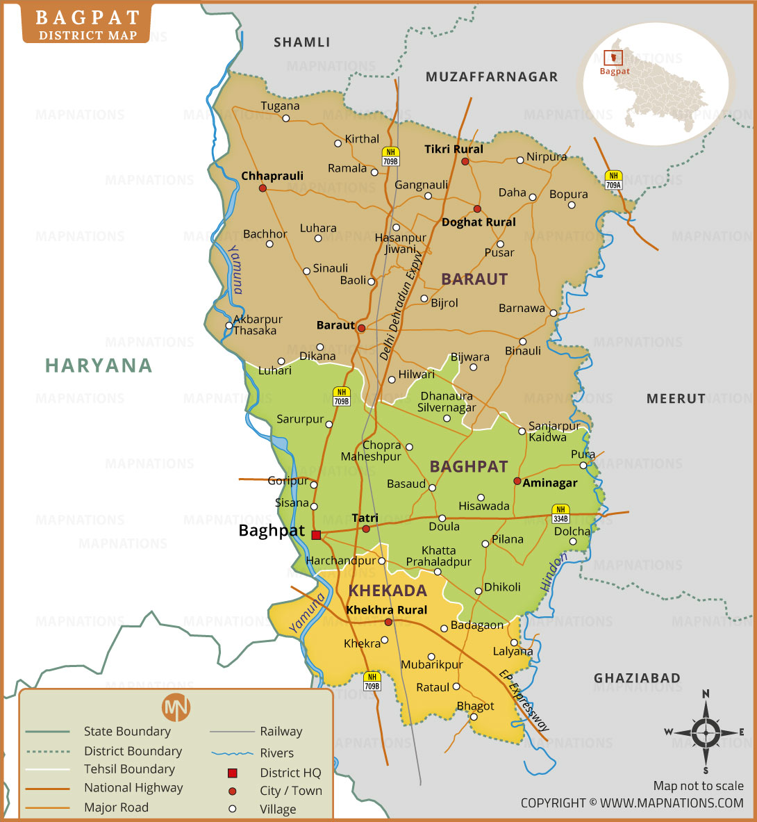
Baghpat is a district located in the western part of Uttar Pradesh, India. It is situated along the Yamuna River and forms part of the National Capital Region (NCR). Baghpat city serves as the district headquarters. The district shares its boundaries with Muzaffarnagar, Shamli, Meerut and Ghaziabad districts, while Haryana lies across the Yamuna River to the west. Baraut, Khekra, Baghpat and Chhaprauli are important towns in this region. The district is divided into three tehsils: Baghpat, Baraut and Khekra. Agriculture is a major economic activity, particularly sugarcane cultivation. This Baghpat district map shows administrative boundaries, tehsil divisions, villages, major roads, national highways, railway lines and rivers, helping users understand the district's geographical layout.
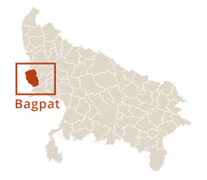
Baghpat district is situated in western Uttar Pradesh, close to the national capital, New Delhi. It lies approximately 40 kilometres northwest of Delhi. The Yamuna River forms its western boundary, separating it from Haryana. This location map highlights Baghpat's position within Uttar Pradesh and its surrounding geographical region.
Bagpat District-Quick Facts
| State | Uttar Pradesh |
|---|---|
| Region | Western Uttar Pradesh |
| District Headquarters | Baghpat |
| Major River | Yamuna and Hindon Rivers |
| Famous Landmark | Puramahadev Temple and Parshvanath Jain Temple |
| Nearby Districts | Shamli, Muzaffarnagar, Meerut and Ghaziabad |
- Agra
- Aligarh
- Ambedkar Nagar
- Amethi
- Amroha
- Auraiya
- Ayodhya
- Azamgarh
- Badaun
- Bagpat
- Bahraich
- Ballia
- Balrampur
- Banda
- Barabanki
- Bareilly
- Basti
- Bijnor
- Bulandshahr
- Chandauli
- Chitrakoot
- Deoria
- Etah
- Etawah
- Farrukhabad
- Fatehpur
- Firozabad
- Gautam Buddha Nagar
- Ghaziabad
- Ghazipur
- Gonda
- Gorakhpur
- Hamirpur
- Hapur
- Hardoi
- Hathras
- Jalaun
- Jaunpur
- Jhansi
- Kannauj
- Kanpur Dehat
- Kanpur Nagar
- Kasganj
- Kaushambi
- Kushinagar
- Lakhimpur Kheri
- Lalitpur
- Lucknow
- Maharajganj
- Mahoba
- Mainpuri
- Mathura
- Mau
- Meerut
- Mirzapur
- Moradabad
- Muzaffarnagar
- Pilibhit
- Pratapgarh
- Prayagraj
- Raebareli
- Rampur
- Saharanpur
- Sant Kabir Nagar
- Sant Ravidas Nagar
- Sambhal
- Shahjahanpur
- Shamli
- Shravasti
- Siddharthnagar
- Sitapur
- Sonbhadra
- Sultanpur
- Unnao
- Varanasi (Kashi)
- Andhra Pradesh
- Arunachal Pradesh
- Assam
- Bihar
- Chhattisgarh
- Goa
- Gujarat
- Haryana
- Himachal Pradesh
- Jharkhand
- Karnataka
- Kerala
- Madhya Pradesh
- Maharashtra
- Manipur
- Meghalaya
- Mizoram
- Nagaland
- Odisha
- Punjab
- Rajasthan
- Sikkim
- Tamil Nadu
- Telangana
- Tripura
- Uttar Pradesh
- Uttarakhand
- West Bengal
- Andaman and Nicobar Islands
- Chandigarh
- Dadra and Nagar Haveli and Daman and Diu
- Delhi (National Capital Territory of Delhi)
- Jammu and Kashmir
- Ladakh
- Lakshadweep
- Puducherry
- Afghanistan
- Albania
- Algeria
- Andorra
- Angola
- Antigua and Barbuda
- Argentina
- Armenia
- Australia
- Austria
- Azerbaijan
- Bahrain
- Bangladesh
- Barbados
- Belarus
- Belgium
- Belize
- Benin
- Bhutan
- Bolivia
- Bosnia and Herzegovina
- Botswana
- Brazil
- Brunei
- Bulgaria
- Burkina Faso
- Burma (Myanmar)
- Burundi
- Cabo Verde
- Cambodia
- Cameroon
- Canada
- Central African Republic
- Chad
- Chile
- China
- Colombia
- Comoros Islands
- Democratic Republic of the Congo
- Costa Rica
- Cote d'Ivoire
- Croatia
- Cuba
- Cyprus
- Czechia
- Denmark
- Djibouti
- Dominica
- Dominican Republic
- Ecuador
- Egypt
- El Salvador
- England
- Equatorial Guinea
- Eritrea
- Estonia
- eSwatini (formerly Swaziland)
- Ethiopia
- Federated States of Micronesia
- Fiji
- Finland
- France
- Gabon
- The Gambia
- Georgia
- Germany
- Ghana
- Greece
- Grenada
- Guatemala
- Guinea
- Guinea-Bissau
- Guyana
- Haiti
- Holy See
- Honduras
- Hungary
- Iceland
- India
- Indonesia
- Iran
- Iraq
- Ireland
- Israel
- Italy
- Jamaica
- Japan
- Jordan
- Kazakhstan
- Kenya
- Kiribati
- Kosovo
- Kuwait
- Kyrgyzstan
- Laos
- Latvia
- Lebanon
- Lesotho
- Liberia
- Libya
- Liechtenstein
- Lithuania
- Luxembourg
- Madagascar
- Malawi
- Malaysia
- Maldives
- Mali
- Malta
- Marshall Islands
- Mauritania
- Mauritius
- Mexico
- Moldova
- Monaco
- Mongolia
- Montenegro
- Morocco
- Mozambique
- Namibia
- Nauru
- Nepal
- Netherlands
- New Zealand
- Nicaragua
- Niger
- Nigeria
- North Korea
- Northern Ireland
- Norway
- Oman
- Pakistan
- Palau
- Panama
- Papua New Guinea
- Paraguay
- Peru
- Philippines
- Poland
- Portugal
- Puerto Rico (USA)
- Qatar
- North Macedonia
- Romania
- Russia
- Rwanda
- Saint Kitts and Nevis
- Saint Lucia
- Saint Vincent & the Grenadines
- Samoa
- San Marino
- Sao Tome and Principe
- Saudi Arabia
- Scotland
- Senegal
- Serbia
- Seychelles
- Sierra Leone
- Singapore
- Slovakia
- Slovenia
- Solomon Islands
- Somalia
- South Africa
- South Korea
- South Sudan
- Spain
- Sri Lanka
- Sudan
- Suriname
- Sweden
- Switzerland
- Syria
- Tajikistan
- Taiwan
- Tanzania
- Thailand
- The Bahamas
- Timor-Leste
- Togo
- Tonga
- Trinidad and Tobago
- Tunisia
- Turkey
- Turkmenistan
- Tuvalu
- Uganda
- Ukraine
- United Arab Emirates
- United Kingdom
- United States of America
- Uruguay
- Uzbekistan
- Vanuatu
- Western Sahara
- Venezuela
- Vietnam
- Wales
- Yemen
- Zambia
- Zimbabwe