UTTARAKHAND LOCATION MAP

About Uttarakhand Location Map
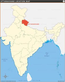
This Uttarakhand location map highlights the state’s position in Northern India. It shares borders with Himachal Pradesh to the northwest, Uttar Pradesh to the south, and international boundaries with China and Nepal. The map clearly shows Uttarakhand’s geographical placement within India, helping users understand its proximity to major regions and neighboring countries. Ideal for educational, geographic, and travel reference, this map offers a simple visual overview of Uttarakhand’s location on the Indian subcontinent.
Quick Facts About Uttarakhand
| Fact | Detail |
|---|---|
| Country | India |
| State Capital | Dehradun |
| Formation Date | 36839 |
| Official Languages | Hindi, Sanskrit (additional official), Garhwali, Kumaoni |
| Area | 53,483 sq km |
| Population (2021 est.) | Around 11.5 million |
| Literacy Rate | Approximately 79.6% |
| State Animal | Alpine Musk Deer (Kasturi Mrig) |
| State Bird | Himalayan Monal |
| State Flower | Brahma Kamal |
| State Tree | Buransh (Rhododendron arboreum) |
| Major Rivers | Ganga, Yamuna, Alaknanda, Mandakini, Pindar, Kali |
| No. of Districts | 13 |
| Largest District (By Area) | Chamoli |
| Borders With | Himachal Pradesh, Uttar Pradesh, China (Tibet), Nepal |
| Major Religion | Hinduism |
| Famous For | Pilgrimage sites (Char Dham), Himalayas, adventure tourism, yoga, wildlife sanctuaries, and natural beauty |

INDIA STATE MAPS


WORLD COUNTRIES
- Afghanistan
- Albania
- Algeria
- Andorra
- Angola
- Antigua and Barbuda
- Argentina
- Armenia
- Australia
- Austria
- Azerbaijan
- Bahrain
- Bangladesh
- Barbados
- Belarus
- Belgium
- Belize
- Benin
- Bhutan
- Bolivia
- Bosnia and Herzegovina
- Botswana
- Brazil
- Brunei
- Bulgaria
- Burkina Faso
- Burma (Myanmar)
- Burundi
- Cabo Verde
- Cambodia
- Cameroon
- Canada
- Central African Republic
- Chad
- Chile
- China
- Colombia
- Comoros Islands
- Democratic Republic of the Congo
- Costa Rica
- Cote d'Ivoire
- Croatia
- Cuba
- Cyprus
- Czechia
- Denmark
- Djibouti
- Dominica
- Dominican Republic
- Ecuador
- Egypt
- El Salvador
- England
- Equatorial Guinea
- Eritrea
- Estonia
- eSwatini (formerly Swaziland)
- Ethiopia
- Federated States of Micronesia
- Fiji
- Finland
- France
- Gabon
- The Gambia
- Georgia
- Germany
- Ghana
- Greece
- Grenada
- Guatemala
- Guinea
- Guinea-Bissau
- Guyana
- Haiti
- Holy See
- Honduras
- Hungary
- Iceland
- India
- Indonesia
- Iran
- Iraq
- Ireland
- Israel
- Italy
- Jamaica
- Japan
- Jordan
- Kazakhstan
- Kenya
- Kiribati
- Kosovo
- Kuwait
- Kyrgyzstan
- Laos
- Latvia
- Lebanon
- Lesotho
- Liberia
- Libya
- Liechtenstein
- Lithuania
- Luxembourg
- Madagascar
- Malawi
- Malaysia
- Maldives
- Mali
- Malta
- Marshall Islands
- Mauritania
- Mauritius
- Mexico
- Moldova
- Monaco
- Mongolia
- Montenegro
- Morocco
- Mozambique
- Namibia
- Nauru
- Nepal
- Netherlands
- New Zealand
- Nicaragua
- Niger
- Nigeria
- North Korea
- Northern Ireland
- Norway
- Oman
- Pakistan
- Palau
- Panama
- Papua New Guinea
- Paraguay
- Peru
- Philippines
- Poland
- Portugal
- Puerto Rico (USA)
- Qatar
- North Macedonia
- Romania
- Russia
- Rwanda
- Saint Kitts and Nevis
- Saint Lucia
- Saint Vincent & the Grenadines
- Samoa
- San Marino
- Sao Tome and Principe
- Saudi Arabia
- Scotland
- Senegal
- Serbia
- Seychelles
- Sierra Leone
- Singapore
- Slovakia
- Slovenia
- Solomon Islands
- Somalia
- South Africa
- South Korea
- South Sudan
- Spain
- Sri Lanka
- Sudan
- Suriname
- Sweden
- Switzerland
- Syria
- Tajikistan
- Taiwan
- Tanzania
- Thailand
- The Bahamas
- Timor-Leste
- Togo
- Tonga
- Trinidad and Tobago
- Tunisia
- Turkey
- Turkmenistan
- Tuvalu
- Uganda
- Ukraine
- United Arab Emirates
- United Kingdom
- United States of America
- Uruguay
- Uzbekistan
- Vanuatu
- Western Sahara
- Venezuela
- Vietnam
- Wales
- Yemen
- Zambia
- Zimbabwe
