Where is Panama?





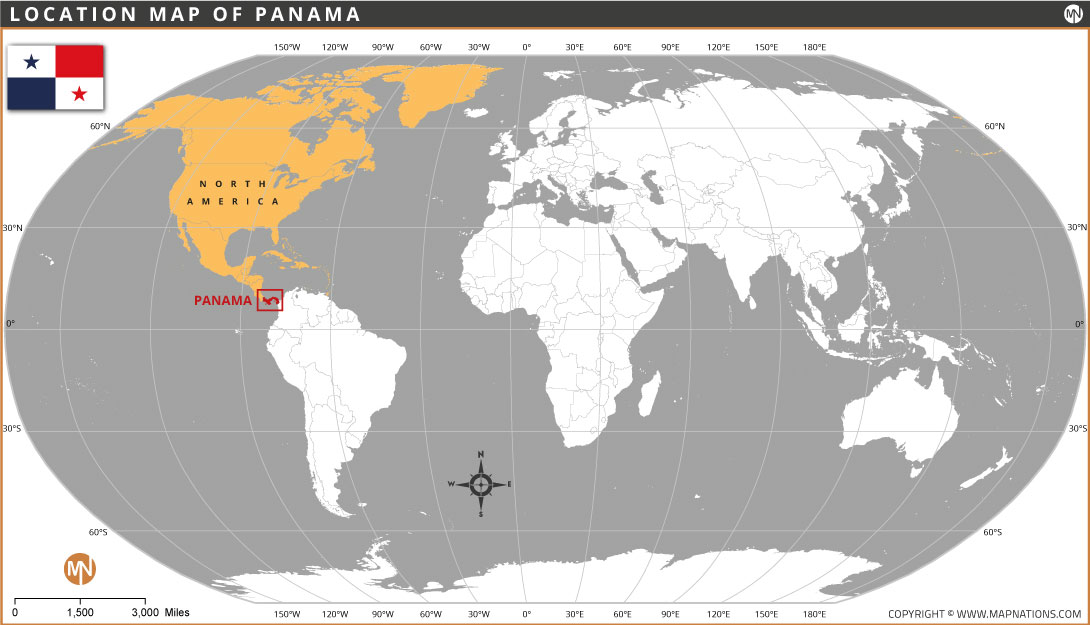
Panama is a country located in Central America, connecting North America and South America. It lies between Costa Rica to the west and Colombia to the east. The Caribbean Sea borders Panama to the north, while the Pacific Ocean lies to the south. Its strategic location makes Panama an important link between the two continents. The country is famous for the Panama Canal, which connects the Atlantic and Pacific Oceans and supports international shipping.
The location map of Panama highlights its position on the world map and shows where the country lies in relation to other continents. Panama has a tropical climate, beautiful coastlines, mountains, and rich biodiversity. Its capital city is Panama City, which serves as the country's political, economic, and cultural center.
Quick Facts About Panama
| Fact | Details |
|---|---|
| Capital City | Panama City |
| Largest City | Panama City |
| Continent | North America |
| Region | Central America |
| Neighboring Countries | Costa Rica and Colombia |
| Official Language | Spanish |
| Currency | Panamanian balboa and US dollar |
| Government | Presidential republic |
| Population | Approximately 4.5 million |
| Total Area | 75,417 km² |
| Nationality | Panamanian |
| Official Religion | No official state religion; religious freedom is protected |
| Major Rivers | Chagres River, Tuira River |
| Highest Peak | Volcán Barú (3,475 m) |
| Surrounding Water Bodies | Caribbean Sea and Pacific Ocean |
| Famous Waterway | Panama Canal |
| Time Zone | UTC-5 |
| Calling Code | 507 |
| Internet TLD | .pa |
| Driving Side | Right |
| National Day | November 3 (Separation Day) |


- Afghanistan
- Albania
- Algeria
- Andorra
- Angola
- Antigua and Barbuda
- Argentina
- Armenia
- Australia
- Austria
- Azerbaijan
- Bahrain
- Bangladesh
- Barbados
- Belarus
- Belgium
- Belize
- Benin
- Bhutan
- Bolivia
- Bosnia and Herzegovina
- Botswana
- Brazil
- Brunei
- Bulgaria
- Burkina Faso
- Burma (Myanmar)
- Burundi
- Cabo Verde
- Cambodia
- Cameroon
- Canada
- Central African Republic
- Chad
- Chile
- China
- Colombia
- Comoros Islands
- Democratic Republic of the Congo
- Costa Rica
- Cote d'Ivoire
- Croatia
- Cuba
- Cyprus
- Czechia
- Denmark
- Djibouti
- Dominica
- Dominican Republic
- Ecuador
- Egypt
- El Salvador
- England
- Equatorial Guinea
- Eritrea
- Estonia
- eSwatini (formerly Swaziland)
- Ethiopia
- Federated States of Micronesia
- Fiji
- Finland
- France
- Gabon
- The Gambia
- Georgia
- Germany
- Ghana
- Greece
- Grenada
- Guatemala
- Guinea
- Guinea-Bissau
- Guyana
- Haiti
- Holy See
- Honduras
- Hungary
- Iceland
- India
- Indonesia
- Iran
- Iraq
- Ireland
- Israel
- Italy
- Jamaica
- Japan
- Jordan
- Kazakhstan
- Kenya
- Kiribati
- Kosovo
- Kuwait
- Kyrgyzstan
- Laos
- Latvia
- Lebanon
- Lesotho
- Liberia
- Libya
- Liechtenstein
- Lithuania
- Luxembourg
- Madagascar
- Malawi
- Malaysia
- Maldives
- Mali
- Malta
- Marshall Islands
- Mauritania
- Mauritius
- Mexico
- Moldova
- Monaco
- Mongolia
- Montenegro
- Morocco
- Mozambique
- Namibia
- Nauru
- Nepal
- Netherlands
- New Zealand
- Nicaragua
- Niger
- Nigeria
- North Korea
- Northern Ireland
- Norway
- Oman
- Pakistan
- Palau
- Panama
- Papua New Guinea
- Paraguay
- Peru
- Philippines
- Poland
- Portugal
- Puerto Rico (USA)
- Qatar
- North Macedonia
- Romania
- Russia
- Rwanda
- Saint Kitts and Nevis
- Saint Lucia
- Saint Vincent & the Grenadines
- Samoa
- San Marino
- Sao Tome and Principe
- Saudi Arabia
- Scotland
- Senegal
- Serbia
- Seychelles
- Sierra Leone
- Singapore
- Slovakia
- Slovenia
- Solomon Islands
- Somalia
- South Africa
- South Korea
- South Sudan
- Spain
- Sri Lanka
- Sudan
- Suriname
- Sweden
- Switzerland
- Syria
- Tajikistan
- Taiwan
- Tanzania
- Thailand
- The Bahamas
- Timor-Leste
- Togo
- Tonga
- Trinidad and Tobago
- Tunisia
- Turkey
- Turkmenistan
- Tuvalu
- Uganda
- Ukraine
- United Arab Emirates
- United Kingdom
- United States of America
- Uruguay
- Uzbekistan
- Vanuatu
- Western Sahara
- Venezuela
- Vietnam
- Wales
- Yemen
- Zambia
- Zimbabwe