CALIFORNIA ECONOMIC REGIONS MAP

About California Economic Regions Map
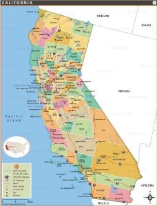
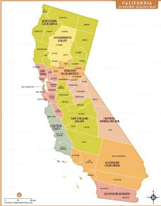
This California economic region map illustrates the state's major economic divisions, including Northern California, Sacramento Valley, Greater Sacramento, Bay Area, Central Coast, San Joaquin Valley, Central Sierra Region, Southern California, and Southern Border. County boundaries are clearly marked to provide detailed geographic context. The map highlights important economic zones such as agricultural areas in the San Joaquin Valley, technology and finance hubs in the Bay Area, and tourism regions along the Central Coast. It serves as a useful reference for understanding California’s regional economy, planning research, educational use, and business analysis. The clear layout helps viewers identify county-level distribution and regional economic relationships across California.
Quick Facts About California Economic Regions
| Economic Region | Major Counties | Major Cities | Primary Economy | Key Characteristics |
|---|---|---|---|---|
| Northern California | Del Norte, Humboldt, Siskiyou | Eureka, Crescent City | Forestry, tourism | Coastal forests, low population |
| Sacramento Valley | Shasta, Tehama, Butte, Glenn | Redding, Chico | Agriculture | Fertile valley, river systems |
| Greater Sacramento | Sacramento, Yolo, Placer | Sacramento, Davis | Government, services | State capital, growing suburbs |
| Bay Area | Alameda, Marin, Contra Costa | San Francisco, Oakland | Technology, finance | Major economic hub |
| Central Coast | Monterey, San Luis Obispo, Santa Barbara | Monterey, Santa Barbara | Tourism, agriculture | Coastal tourism, vineyards |
| San Joaquin Valley | Fresno, Kern, Tulare, Kings | Fresno, Bakersfield | Agriculture, energy | Major food production region |
| Central Sierra Region | Alpine, Mono, Inyo | Bishop, Mammoth Lakes | Tourism | Mountain recreation economy |
| Southern California | Los Angeles, Orange, Riverside | Los Angeles, Anaheim | Entertainment, trade | Largest population center |
| Southern Border | San Diego, Imperial | San Diego, El Centro | Trade, agriculture | US-Mexico border economy |


- Alabama
- Alaska
- Arizona
- Arkansas
- California
- Colorado
- Connecticut
- Delaware
- Florida
- Georgia
- Hawaii
- Idaho
- Illinois
- Indiana
- Iowa
- Kansas
- Kentucky
- Louisiana
- Maine
- Maryland
- Massachusetts
- Michigan
- Minnesota
- Mississippi
- Missouri
- Montana
- Nebraska
- Nevada
- New Hampshire
- New Jersey
- New Mexico
- New York
- North Carolina
- North Dakota
- Ohio
- Oklahoma
- Oregon
- Pennsylvania
- Rhode Island
- South Carolina
- South Dakota
- Tennessee
- Texas
- Utah
- Vermont
- Virginia
- Washington
- West Virginia
- Wisconsin
- Wyoming
- District of Columbia (Federal district)
- Afghanistan
- Albania
- Algeria
- Andorra
- Angola
- Antigua and Barbuda
- Argentina
- Armenia
- Australia
- Austria
- Azerbaijan
- Bahrain
- Bangladesh
- Barbados
- Belarus
- Belgium
- Belize
- Benin
- Bhutan
- Bolivia
- Bosnia and Herzegovina
- Botswana
- Brazil
- Brunei
- Bulgaria
- Burkina Faso
- Burma (Myanmar)
- Burundi
- Cabo Verde
- Cambodia
- Cameroon
- Canada
- Central African Republic
- Chad
- Chile
- China
- Colombia
- Comoros Islands
- Democratic Republic of the Congo
- Costa Rica
- Cote d'Ivoire
- Croatia
- Cuba
- Cyprus
- Czechia
- Denmark
- Djibouti
- Dominica
- Dominican Republic
- Ecuador
- Egypt
- El Salvador
- England
- Equatorial Guinea
- Eritrea
- Estonia
- eSwatini (formerly Swaziland)
- Ethiopia
- Federated States of Micronesia
- Fiji
- Finland
- France
- Gabon
- The Gambia
- Georgia
- Germany
- Ghana
- Greece
- Grenada
- Guatemala
- Guinea
- Guinea-Bissau
- Guyana
- Haiti
- Holy See
- Honduras
- Hungary
- Iceland
- India
- Indonesia
- Iran
- Iraq
- Ireland
- Israel
- Italy
- Jamaica
- Japan
- Jordan
- Kazakhstan
- Kenya
- Kiribati
- Kosovo
- Kuwait
- Kyrgyzstan
- Laos
- Latvia
- Lebanon
- Lesotho
- Liberia
- Libya
- Liechtenstein
- Lithuania
- Luxembourg
- Madagascar
- Malawi
- Malaysia
- Maldives
- Mali
- Malta
- Marshall Islands
- Mauritania
- Mauritius
- Mexico
- Moldova
- Monaco
- Mongolia
- Montenegro
- Morocco
- Mozambique
- Namibia
- Nauru
- Nepal
- Netherlands
- New Zealand
- Nicaragua
- Niger
- Nigeria
- North Korea
- Northern Ireland
- Norway
- Oman
- Pakistan
- Palau
- Panama
- Papua New Guinea
- Paraguay
- Peru
- Philippines
- Poland
- Portugal
- Puerto Rico (USA)
- Qatar
- North Macedonia
- Romania
- Russia
- Rwanda
- Saint Kitts and Nevis
- Saint Lucia
- Saint Vincent & the Grenadines
- Samoa
- San Marino
- Sao Tome and Principe
- Saudi Arabia
- Scotland
- Senegal
- Serbia
- Seychelles
- Sierra Leone
- Singapore
- Slovakia
- Slovenia
- Solomon Islands
- Somalia
- South Africa
- South Korea
- South Sudan
- Spain
- Sri Lanka
- Sudan
- Suriname
- Sweden
- Switzerland
- Syria
- Tajikistan
- Taiwan
- Tanzania
- Thailand
- The Bahamas
- Timor-Leste
- Togo
- Tonga
- Trinidad and Tobago
- Tunisia
- Turkey
- Turkmenistan
- Tuvalu
- Uganda
- Ukraine
- United Arab Emirates
- United Kingdom
- United States of America
- Uruguay
- Uzbekistan
- Vanuatu
- Western Sahara
- Venezuela
- Vietnam
- Wales
- Yemen
- Zambia
- Zimbabwe
