Middlesex County Map

About Middlesex County Map
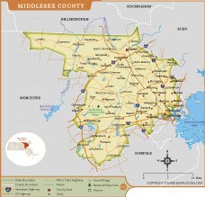
The Middlesex County Map of Massachusetts provides a detailed view of one of the state's most populous and historically significant counties. The map highlights major cities including Cambridge, Lowell, Waltham, Marlborough, and Framingham, along with numerous towns and villages across the county.
Key transportation routes such as Interstate 95, Interstate 495, U.S. highways, and state highways are clearly marked, making the map useful for navigation and regional planning. Rivers, reservoirs, parks, airports, and county boundaries are also displayed, offering valuable geographic context. This map serves as an excellent reference for education, travel, research, and local area exploration.
Middlesex County Map Quick Facts
| Fact | Details |
|---|---|
| Official Name | Middlesex County |
| State | Massachusetts |
| Country | United States |
| Founded | May 10, 1643 |
| Incorporated | Established as one of the original counties of the Massachusetts Bay Colony |
| Population | Approximately 1.63 million (2020 Census) |
| County | Historically Cambridge; county government abolished in 1997 |
| Area | 847 sq mi (2,194 km²) |
| Time Zone | Eastern Time Zone (ET) |
| ZIP Codes | 01701–01890 (various ZIP codes across the county) |
| Area Code | 339, 351, 617, 781, 978 |
| Known For | Harvard University, MIT, technology corridor, historic sites, education and innovation |
| Major Airport | Laurence G. Hanscom Field (BED); nearby Boston Logan International Airport |
| Climate | Humid Continental Climate with warm summers and cold, snowy winters |
| Nickname | The Innovation Hub of Massachusetts |
| Major Highways | Interstate 95, Interstate 495, Interstate 90 (Mass Pike), U.S. Route 3, Route 2 |
| Nearby Border | Essex County, Norfolk County, Worcester County, Hillsborough County (NH), Rockingham County (NH) |
| Major Attractions | Harvard University, MIT, Walden Pond State Reservation, Minute Man National Historical Park, Middlesex Fells Reservation, Lowell National Historical Park, Assabet River National Wildlife Refuge |
USA STATES
- Alabama
- Alaska
- Arizona
- Arkansas
- California
- Colorado
- Connecticut
- Delaware
- Florida
- Georgia
- Hawaii
- Idaho
- Illinois
- Indiana
- Iowa
- Kansas
- Kentucky
- Louisiana
- Maine
- Maryland
- Massachusetts
- Michigan
- Minnesota
- Mississippi
- Missouri
- Montana
- Nebraska
- Nevada
- New Hampshire
- New Jersey
- New Mexico
- New York
- North Carolina
- North Dakota
- Ohio
- Oklahoma
- Oregon
- Pennsylvania
- Rhode Island
- South Carolina
- South Dakota
- Tennessee
- Texas
- Utah
- Vermont
- Virginia
- Washington
- West Virginia
- Wisconsin
- Wyoming
- District of Columbia (Federal district)
WORLD COUNTRIES
- Afghanistan
- Albania
- Algeria
- Andorra
- Angola
- Antigua and Barbuda
- Argentina
- Armenia
- Australia
- Austria
- Azerbaijan
- Bahrain
- Bangladesh
- Barbados
- Belarus
- Belgium
- Belize
- Benin
- Bhutan
- Bolivia
- Bosnia and Herzegovina
- Botswana
- Brazil
- Brunei
- Bulgaria
- Burkina Faso
- Burma (Myanmar)
- Burundi
- Cabo Verde
- Cambodia
- Cameroon
- Canada
- Central African Republic
- Chad
- Chile
- China
- Colombia
- Comoros Islands
- Democratic Republic of the Congo
- Costa Rica
- Cote d'Ivoire
- Croatia
- Cuba
- Cyprus
- Czechia
- Denmark
- Djibouti
- Dominica
- Dominican Republic
- Ecuador
- Egypt
- El Salvador
- England
- Equatorial Guinea
- Eritrea
- Estonia
- eSwatini (formerly Swaziland)
- Ethiopia
- Federated States of Micronesia
- Fiji
- Finland
- France
- Gabon
- The Gambia
- Georgia
- Germany
- Ghana
- Greece
- Grenada
- Guatemala
- Guinea
- Guinea-Bissau
- Guyana
- Haiti
- Holy See
- Honduras
- Hungary
- Iceland
- India
- Indonesia
- Iran
- Iraq
- Ireland
- Israel
- Italy
- Jamaica
- Japan
- Jordan
- Kazakhstan
- Kenya
- Kiribati
- Kosovo
- Kuwait
- Kyrgyzstan
- Laos
- Latvia
- Lebanon
- Lesotho
- Liberia
- Libya
- Liechtenstein
- Lithuania
- Luxembourg
- Madagascar
- Malawi
- Malaysia
- Maldives
- Mali
- Malta
- Marshall Islands
- Mauritania
- Mauritius
- Mexico
- Moldova
- Monaco
- Mongolia
- Montenegro
- Morocco
- Mozambique
- Namibia
- Nauru
- Nepal
- Netherlands
- New Zealand
- Nicaragua
- Niger
- Nigeria
- North Korea
- Northern Ireland
- Norway
- Oman
- Pakistan
- Palau
- Panama
- Papua New Guinea
- Paraguay
- Peru
- Philippines
- Poland
- Portugal
- Puerto Rico (USA)
- Qatar
- North Macedonia
- Romania
- Russia
- Rwanda
- Saint Kitts and Nevis
- Saint Lucia
- Saint Vincent & the Grenadines
- Samoa
- San Marino
- Sao Tome and Principe
- Saudi Arabia
- Scotland
- Senegal
- Serbia
- Seychelles
- Sierra Leone
- Singapore
- Slovakia
- Slovenia
- Solomon Islands
- Somalia
- South Africa
- South Korea
- South Sudan
- Spain
- Sri Lanka
- Sudan
- Suriname
- Sweden
- Switzerland
- Syria
- Tajikistan
- Taiwan
- Tanzania
- Thailand
- The Bahamas
- Timor-Leste
- Togo
- Tonga
- Trinidad and Tobago
- Tunisia
- Turkey
- Turkmenistan
- Tuvalu
- Uganda
- Ukraine
- United Arab Emirates
- United Kingdom
- United States of America
- Uruguay
- Uzbekistan
- Vanuatu
- Western Sahara
- Venezuela
- Vietnam
- Wales
- Yemen
- Zambia
- Zimbabwe