Wayne County Map

About Wayne County Map
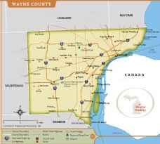
The Wayne County Map provides a detailed overview of one of Michigan’s most important counties, highlighting major cities, towns, highways, rivers, and transportation networks. The map clearly identifies Detroit, the county seat, along with communities such as Dearborn, Livonia, Westland, Taylor, Romulus, and Wyandotte. Interstate highways including I-75, I-94, I-96, and I-275 are prominently displayed for easy reference.
This map also shows Wayne County’s geographic relationship with neighboring counties, Lake Erie, and the Canadian border. Key landmarks such as Detroit Metropolitan Wayne County Airport, state parks, and major roadways are marked to assist travelers, researchers, students, and planners. It serves as a valuable resource for understanding the county’s layout, connectivity, and regional significance within southeastern Michigan.
Wayne County Map Quick Facts
| Fact | Details |
|---|---|
| Official Name | Wayne County |
| State | Michigan |
| Country | United States |
| Founded | August 15, 1796 |
| Incorporated | Organized as a county in 1815 |
| Population | Approximately 1.75 million (2020 Census) |
| County | Detroit |
| Area | 673 sq mi (1,743 km²) |
| Time Zone | Eastern Time Zone (ET) |
| ZIP Codes | 48001–48288 (various ZIP codes within the county) |
| Area Code | 313, 734 |
| Known For | Detroit, automotive industry, Motown music, manufacturing, international border crossing |
| Major Airport | Detroit Metropolitan Wayne County Airport (DTW) |
| Climate | Humid Continental Climate |
| Nickname | Home of Detroit; Motor City County |
| Major Highways | I-75, I-94, I-96, I-275, M-10, M-39, US-12, US-24 |
| Nearby Border | Oakland County, Macomb County, Washtenaw County, Monroe County, and Ontario (Canada) |
| Major Attractions | Detroit Riverwalk, Henry Ford Museum, Greenfield Village, Motown Museum, Belle Isle Park, Detroit Institute of Arts, Comerica Park, Ford Field |
- Alabama
- Alaska
- Arizona
- Arkansas
- California
- Colorado
- Connecticut
- Delaware
- Florida
- Georgia
- Hawaii
- Idaho
- Illinois
- Indiana
- Iowa
- Kansas
- Kentucky
- Louisiana
- Maine
- Maryland
- Massachusetts
- Michigan
- Minnesota
- Mississippi
- Missouri
- Montana
- Nebraska
- Nevada
- New Hampshire
- New Jersey
- New Mexico
- New York
- North Carolina
- North Dakota
- Ohio
- Oklahoma
- Oregon
- Pennsylvania
- Rhode Island
- South Carolina
- South Dakota
- Tennessee
- Texas
- Utah
- Vermont
- Virginia
- Washington
- West Virginia
- Wisconsin
- Wyoming
- District of Columbia (Federal district)
- Afghanistan
- Albania
- Algeria
- Andorra
- Angola
- Antigua and Barbuda
- Argentina
- Armenia
- Australia
- Austria
- Azerbaijan
- Bahrain
- Bangladesh
- Barbados
- Belarus
- Belgium
- Belize
- Benin
- Bhutan
- Bolivia
- Bosnia and Herzegovina
- Botswana
- Brazil
- Brunei
- Bulgaria
- Burkina Faso
- Burma (Myanmar)
- Burundi
- Cabo Verde
- Cambodia
- Cameroon
- Canada
- Central African Republic
- Chad
- Chile
- China
- Colombia
- Comoros Islands
- Democratic Republic of the Congo
- Costa Rica
- Cote d'Ivoire
- Croatia
- Cuba
- Cyprus
- Czechia
- Denmark
- Djibouti
- Dominica
- Dominican Republic
- Ecuador
- Egypt
- El Salvador
- England
- Equatorial Guinea
- Eritrea
- Estonia
- eSwatini (formerly Swaziland)
- Ethiopia
- Federated States of Micronesia
- Fiji
- Finland
- France
- Gabon
- The Gambia
- Georgia
- Germany
- Ghana
- Greece
- Grenada
- Guatemala
- Guinea
- Guinea-Bissau
- Guyana
- Haiti
- Holy See
- Honduras
- Hungary
- Iceland
- India
- Indonesia
- Iran
- Iraq
- Ireland
- Israel
- Italy
- Jamaica
- Japan
- Jordan
- Kazakhstan
- Kenya
- Kiribati
- Kosovo
- Kuwait
- Kyrgyzstan
- Laos
- Latvia
- Lebanon
- Lesotho
- Liberia
- Libya
- Liechtenstein
- Lithuania
- Luxembourg
- Madagascar
- Malawi
- Malaysia
- Maldives
- Mali
- Malta
- Marshall Islands
- Mauritania
- Mauritius
- Mexico
- Moldova
- Monaco
- Mongolia
- Montenegro
- Morocco
- Mozambique
- Namibia
- Nauru
- Nepal
- Netherlands
- New Zealand
- Nicaragua
- Niger
- Nigeria
- North Korea
- Northern Ireland
- Norway
- Oman
- Pakistan
- Palau
- Panama
- Papua New Guinea
- Paraguay
- Peru
- Philippines
- Poland
- Portugal
- Puerto Rico (USA)
- Qatar
- North Macedonia
- Romania
- Russia
- Rwanda
- Saint Kitts and Nevis
- Saint Lucia
- Saint Vincent & the Grenadines
- Samoa
- San Marino
- Sao Tome and Principe
- Saudi Arabia
- Scotland
- Senegal
- Serbia
- Seychelles
- Sierra Leone
- Singapore
- Slovakia
- Slovenia
- Solomon Islands
- Somalia
- South Africa
- South Korea
- South Sudan
- Spain
- Sri Lanka
- Sudan
- Suriname
- Sweden
- Switzerland
- Syria
- Tajikistan
- Taiwan
- Tanzania
- Thailand
- The Bahamas
- Timor-Leste
- Togo
- Tonga
- Trinidad and Tobago
- Tunisia
- Turkey
- Turkmenistan
- Tuvalu
- Uganda
- Ukraine
- United Arab Emirates
- United Kingdom
- United States of America
- Uruguay
- Uzbekistan
- Vanuatu
- Western Sahara
- Venezuela
- Vietnam
- Wales
- Yemen
- Zambia
- Zimbabwe