Hennepin County Map

About Hennepin County Map
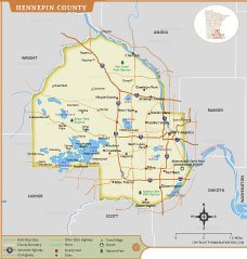
This detailed Hennepin County map highlights the geographic layout of Minnesota’s most populous county. It features major cities including Minneapolis, Bloomington, Edina, Minnetonka, Brooklyn Park, Maple Grove, and Eden Prairie. The map also displays county boundaries, interstate highways, state roads, and important transportation connections throughout the region.
Natural and recreational features such as the Minnesota River, Lake Minnetonka, Medicine Lake, Lake Harriet, and several park reserves are clearly marked. Minneapolis–Saint Paul International Airport is also shown, making the map useful for travel, educational, and planning purposes. This map provides an accurate visual reference for understanding Hennepin County’s communities, infrastructure, waterways, and surrounding counties.
Hennepin County Map Quick Facts
| Fact | Details |
|---|---|
| Official Name | Hennepin County |
| State | Minnesota |
| Country | United States |
| Founded | March 6, 1852 |
| Incorporated | Organized as a county in 1852 |
| Population | 1,281,565 (2020 Census) |
| County | Minneapolis |
| Area | 606.7 sq mi (1,571.5 km²) |
| Time Zone | Central Time (CT) |
| ZIP Codes | 55305–55391, 55401–55488 (various ZIP codes) |
| Area Code | 612, 763, 952 |
| Known For | Minneapolis, Lake Minnetonka, Twin Cities metro area, parks, lakes, and economic hub of Minnesota |
| Major Airport | Minneapolis–Saint Paul International Airport (MSP) |
| Climate | Humid Continental Climate with cold winters and warm summers |
| Nickname | Gateway to the Twin Cities |
| Major Highways | I-35W, I-94, I-394, I-494, I-694, US 12, US 169, US 52 |
| Nearby Border | Anoka, Ramsey, Dakota, Scott, Carver, Wright, and Sherburne Counties |
| Major Attractions | Minneapolis Downtown, Lake Minnetonka, Minnehaha Falls, Chain of Lakes, Target Field, U.S. Bank Stadium, Walker Art Center, Minneapolis Sculpture Garden |
- Alabama
- Alaska
- Arizona
- Arkansas
- California
- Colorado
- Connecticut
- Delaware
- Florida
- Georgia
- Hawaii
- Idaho
- Illinois
- Indiana
- Iowa
- Kansas
- Kentucky
- Louisiana
- Maine
- Maryland
- Massachusetts
- Michigan
- Minnesota
- Mississippi
- Missouri
- Montana
- Nebraska
- Nevada
- New Hampshire
- New Jersey
- New Mexico
- New York
- North Carolina
- North Dakota
- Ohio
- Oklahoma
- Oregon
- Pennsylvania
- Rhode Island
- South Carolina
- South Dakota
- Tennessee
- Texas
- Utah
- Vermont
- Virginia
- Washington
- West Virginia
- Wisconsin
- Wyoming
- District of Columbia (Federal district)
- Afghanistan
- Albania
- Algeria
- Andorra
- Angola
- Antigua and Barbuda
- Argentina
- Armenia
- Australia
- Austria
- Azerbaijan
- Bahrain
- Bangladesh
- Barbados
- Belarus
- Belgium
- Belize
- Benin
- Bhutan
- Bolivia
- Bosnia and Herzegovina
- Botswana
- Brazil
- Brunei
- Bulgaria
- Burkina Faso
- Burma (Myanmar)
- Burundi
- Cabo Verde
- Cambodia
- Cameroon
- Canada
- Central African Republic
- Chad
- Chile
- China
- Colombia
- Comoros Islands
- Democratic Republic of the Congo
- Costa Rica
- Cote d'Ivoire
- Croatia
- Cuba
- Cyprus
- Czechia
- Denmark
- Djibouti
- Dominica
- Dominican Republic
- Ecuador
- Egypt
- El Salvador
- England
- Equatorial Guinea
- Eritrea
- Estonia
- eSwatini (formerly Swaziland)
- Ethiopia
- Federated States of Micronesia
- Fiji
- Finland
- France
- Gabon
- The Gambia
- Georgia
- Germany
- Ghana
- Greece
- Grenada
- Guatemala
- Guinea
- Guinea-Bissau
- Guyana
- Haiti
- Holy See
- Honduras
- Hungary
- Iceland
- India
- Indonesia
- Iran
- Iraq
- Ireland
- Israel
- Italy
- Jamaica
- Japan
- Jordan
- Kazakhstan
- Kenya
- Kiribati
- Kosovo
- Kuwait
- Kyrgyzstan
- Laos
- Latvia
- Lebanon
- Lesotho
- Liberia
- Libya
- Liechtenstein
- Lithuania
- Luxembourg
- Madagascar
- Malawi
- Malaysia
- Maldives
- Mali
- Malta
- Marshall Islands
- Mauritania
- Mauritius
- Mexico
- Moldova
- Monaco
- Mongolia
- Montenegro
- Morocco
- Mozambique
- Namibia
- Nauru
- Nepal
- Netherlands
- New Zealand
- Nicaragua
- Niger
- Nigeria
- North Korea
- Northern Ireland
- Norway
- Oman
- Pakistan
- Palau
- Panama
- Papua New Guinea
- Paraguay
- Peru
- Philippines
- Poland
- Portugal
- Puerto Rico (USA)
- Qatar
- North Macedonia
- Romania
- Russia
- Rwanda
- Saint Kitts and Nevis
- Saint Lucia
- Saint Vincent & the Grenadines
- Samoa
- San Marino
- Sao Tome and Principe
- Saudi Arabia
- Scotland
- Senegal
- Serbia
- Seychelles
- Sierra Leone
- Singapore
- Slovakia
- Slovenia
- Solomon Islands
- Somalia
- South Africa
- South Korea
- South Sudan
- Spain
- Sri Lanka
- Sudan
- Suriname
- Sweden
- Switzerland
- Syria
- Tajikistan
- Taiwan
- Tanzania
- Thailand
- The Bahamas
- Timor-Leste
- Togo
- Tonga
- Trinidad and Tobago
- Tunisia
- Turkey
- Turkmenistan
- Tuvalu
- Uganda
- Ukraine
- United Arab Emirates
- United Kingdom
- United States of America
- Uruguay
- Uzbekistan
- Vanuatu
- Western Sahara
- Venezuela
- Vietnam
- Wales
- Yemen
- Zambia
- Zimbabwe