Bergen County Map

About Bergen County Map
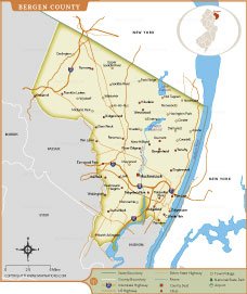
The Bergen County Map provides a detailed view of one of New Jersey’s most populous counties. Located in the northeastern part of the state, Bergen County borders New York and includes numerous cities, boroughs, and townships. This map highlights major communities such as Hackensack, Fort Lee, Paramus, Englewood, Ridgewood, and Garfield.
The map also displays important transportation routes, including Interstate 80, Interstate 95, U.S. highways, state highways, rivers, and county boundaries. Natural features such as the Hudson River, Lake Tappan, and the Oradell Reservoir are clearly marked, helping users understand the county’s geography. Ideal for travelers, students, researchers, and map enthusiasts, this Bergen County map serves as a valuable reference for exploring local infrastructure, municipal boundaries, and key landmarks throughout this important New Jersey county.
Bergen County Map Quick Facts
| Fact | Details |
|---|---|
| Official Name | Bergen County |
| State | New Jersey |
| Country | United States |
| Founded | March 7, 1683 |
| Incorporated | Established as one of New Jersey's original counties in 1683 |
| Population | Approximately 955,000 (2024 estimate) |
| County | Hackensack |
| Area | 246.7 sq mi (638.9 sq km) |
| Time Zone | Eastern Time Zone (ET) |
| ZIP Codes | 07010–07699 (various municipalities) |
| Area Code | 201 and 551 |
| Known For | Proximity to New York City, affluent suburbs, shopping centers, and diverse communities |
| Major Airport | Teterboro Airport |
| Climate | Humid Subtropical / Humid Continental |
| Nickname | Gateway to New Jersey |
| Major Highways | I-80, I-95, Garden State Parkway, US-1/9, US-46, NJ-4, NJ-17 |
| Nearby Border | New York State (Rockland County and New York City) |
| Major Attractions | The Palisades, Bergen County Zoo, Ramapo Valley County Reservation, Riverside Square Mall, Overpeck County Park, Historic New Bridge Landing |
- Alabama
- Alaska
- Arizona
- Arkansas
- California
- Colorado
- Connecticut
- Delaware
- Florida
- Georgia
- Hawaii
- Idaho
- Illinois
- Indiana
- Iowa
- Kansas
- Kentucky
- Louisiana
- Maine
- Maryland
- Massachusetts
- Michigan
- Minnesota
- Mississippi
- Missouri
- Montana
- Nebraska
- Nevada
- New Hampshire
- New Jersey
- New Mexico
- New York
- North Carolina
- North Dakota
- Ohio
- Oklahoma
- Oregon
- Pennsylvania
- Rhode Island
- South Carolina
- South Dakota
- Tennessee
- Texas
- Utah
- Vermont
- Virginia
- Washington
- West Virginia
- Wisconsin
- Wyoming
- District of Columbia (Federal district)
- Afghanistan
- Albania
- Algeria
- Andorra
- Angola
- Antigua and Barbuda
- Argentina
- Armenia
- Australia
- Austria
- Azerbaijan
- Bahrain
- Bangladesh
- Barbados
- Belarus
- Belgium
- Belize
- Benin
- Bhutan
- Bolivia
- Bosnia and Herzegovina
- Botswana
- Brazil
- Brunei
- Bulgaria
- Burkina Faso
- Burma (Myanmar)
- Burundi
- Cabo Verde
- Cambodia
- Cameroon
- Canada
- Central African Republic
- Chad
- Chile
- China
- Colombia
- Comoros Islands
- Democratic Republic of the Congo
- Costa Rica
- Cote d'Ivoire
- Croatia
- Cuba
- Cyprus
- Czechia
- Denmark
- Djibouti
- Dominica
- Dominican Republic
- Ecuador
- Egypt
- El Salvador
- England
- Equatorial Guinea
- Eritrea
- Estonia
- eSwatini (formerly Swaziland)
- Ethiopia
- Federated States of Micronesia
- Fiji
- Finland
- France
- Gabon
- The Gambia
- Georgia
- Germany
- Ghana
- Greece
- Grenada
- Guatemala
- Guinea
- Guinea-Bissau
- Guyana
- Haiti
- Holy See
- Honduras
- Hungary
- Iceland
- India
- Indonesia
- Iran
- Iraq
- Ireland
- Israel
- Italy
- Jamaica
- Japan
- Jordan
- Kazakhstan
- Kenya
- Kiribati
- Kosovo
- Kuwait
- Kyrgyzstan
- Laos
- Latvia
- Lebanon
- Lesotho
- Liberia
- Libya
- Liechtenstein
- Lithuania
- Luxembourg
- Madagascar
- Malawi
- Malaysia
- Maldives
- Mali
- Malta
- Marshall Islands
- Mauritania
- Mauritius
- Mexico
- Moldova
- Monaco
- Mongolia
- Montenegro
- Morocco
- Mozambique
- Namibia
- Nauru
- Nepal
- Netherlands
- New Zealand
- Nicaragua
- Niger
- Nigeria
- North Korea
- Northern Ireland
- Norway
- Oman
- Pakistan
- Palau
- Panama
- Papua New Guinea
- Paraguay
- Peru
- Philippines
- Poland
- Portugal
- Puerto Rico (USA)
- Qatar
- North Macedonia
- Romania
- Russia
- Rwanda
- Saint Kitts and Nevis
- Saint Lucia
- Saint Vincent & the Grenadines
- Samoa
- San Marino
- Sao Tome and Principe
- Saudi Arabia
- Scotland
- Senegal
- Serbia
- Seychelles
- Sierra Leone
- Singapore
- Slovakia
- Slovenia
- Solomon Islands
- Somalia
- South Africa
- South Korea
- South Sudan
- Spain
- Sri Lanka
- Sudan
- Suriname
- Sweden
- Switzerland
- Syria
- Tajikistan
- Taiwan
- Tanzania
- Thailand
- The Bahamas
- Timor-Leste
- Togo
- Tonga
- Trinidad and Tobago
- Tunisia
- Turkey
- Turkmenistan
- Tuvalu
- Uganda
- Ukraine
- United Arab Emirates
- United Kingdom
- United States of America
- Uruguay
- Uzbekistan
- Vanuatu
- Western Sahara
- Venezuela
- Vietnam
- Wales
- Yemen
- Zambia
- Zimbabwe