Kings County Map

About Kings County Map
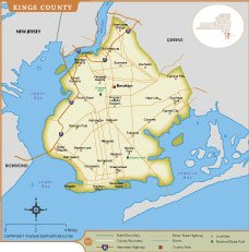
The Kings County Map provides a detailed view of Brooklyn, the most populous borough of New York City. This map highlights major neighborhoods including Williamsburg, Bushwick, Flatbush, Bensonhurst, Brighton Beach, Canarsie, and Brooklyn Heights. It also displays important transportation routes, interstate highways, local roads, parks, rivers, and surrounding water bodies such as Jamaica Bay and Upper Bay. County boundaries, localities, and notable landmarks are clearly marked, making the map useful for residents, travelers, researchers, and students. Kings County is known for its diverse communities, cultural attractions, historic districts, and vibrant waterfront areas. Whether you are planning a visit, studying local geography, or exploring Brooklyn’s neighborhoods, this map offers valuable geographic and navigational information.
Kings County Map Quick Facts
| Fact | Details |
|---|---|
| Official Name | Kings County |
| State | New York |
| Country | United States |
| Founded | 1683 |
| Incorporated | County established in 1683; consolidated into New York City in 1898 |
| Population | Approximately 2.7 million (2024 estimate) |
| County | Brooklyn |
| Area | 96.9 sq mi (251 sq km) |
| Time Zone | Eastern Time Zone (ET) – UTC-5 / UTC-4 (DST) |
| ZIP Codes | 11201–11239, 11249, and others within Brooklyn |
| Area Code | 718, 347, 929, 917 |
| Known For | Brooklyn, diverse communities, cultural attractions, Coney Island, and historic neighborhoods |
| Major Airport | John F. Kennedy International Airport |
| Climate | Humid Subtropical Climate with warm summers and cool winters |
| Nickname | Borough of Brooklyn |
| Major Highways | I-278 (Brooklyn-Queens Expressway), Belt Parkway, Ocean Parkway |
| Nearby Border | Queens County, Richmond County (Staten Island), and New Jersey across Upper Bay |
| Major Attractions | Brooklyn Bridge, Prospect Park, Coney Island, Brooklyn Museum, Brooklyn Botanic Garden |
- Alabama
- Alaska
- Arizona
- Arkansas
- California
- Colorado
- Connecticut
- Delaware
- Florida
- Georgia
- Hawaii
- Idaho
- Illinois
- Indiana
- Iowa
- Kansas
- Kentucky
- Louisiana
- Maine
- Maryland
- Massachusetts
- Michigan
- Minnesota
- Mississippi
- Missouri
- Montana
- Nebraska
- Nevada
- New Hampshire
- New Jersey
- New Mexico
- New York
- North Carolina
- North Dakota
- Ohio
- Oklahoma
- Oregon
- Pennsylvania
- Rhode Island
- South Carolina
- South Dakota
- Tennessee
- Texas
- Utah
- Vermont
- Virginia
- Washington
- West Virginia
- Wisconsin
- Wyoming
- District of Columbia (Federal district)
- Afghanistan
- Albania
- Algeria
- Andorra
- Angola
- Antigua and Barbuda
- Argentina
- Armenia
- Australia
- Austria
- Azerbaijan
- Bahrain
- Bangladesh
- Barbados
- Belarus
- Belgium
- Belize
- Benin
- Bhutan
- Bolivia
- Bosnia and Herzegovina
- Botswana
- Brazil
- Brunei
- Bulgaria
- Burkina Faso
- Burma (Myanmar)
- Burundi
- Cabo Verde
- Cambodia
- Cameroon
- Canada
- Central African Republic
- Chad
- Chile
- China
- Colombia
- Comoros Islands
- Democratic Republic of the Congo
- Costa Rica
- Cote d'Ivoire
- Croatia
- Cuba
- Cyprus
- Czechia
- Denmark
- Djibouti
- Dominica
- Dominican Republic
- Ecuador
- Egypt
- El Salvador
- England
- Equatorial Guinea
- Eritrea
- Estonia
- eSwatini (formerly Swaziland)
- Ethiopia
- Federated States of Micronesia
- Fiji
- Finland
- France
- Gabon
- The Gambia
- Georgia
- Germany
- Ghana
- Greece
- Grenada
- Guatemala
- Guinea
- Guinea-Bissau
- Guyana
- Haiti
- Holy See
- Honduras
- Hungary
- Iceland
- India
- Indonesia
- Iran
- Iraq
- Ireland
- Israel
- Italy
- Jamaica
- Japan
- Jordan
- Kazakhstan
- Kenya
- Kiribati
- Kosovo
- Kuwait
- Kyrgyzstan
- Laos
- Latvia
- Lebanon
- Lesotho
- Liberia
- Libya
- Liechtenstein
- Lithuania
- Luxembourg
- Madagascar
- Malawi
- Malaysia
- Maldives
- Mali
- Malta
- Marshall Islands
- Mauritania
- Mauritius
- Mexico
- Moldova
- Monaco
- Mongolia
- Montenegro
- Morocco
- Mozambique
- Namibia
- Nauru
- Nepal
- Netherlands
- New Zealand
- Nicaragua
- Niger
- Nigeria
- North Korea
- Northern Ireland
- Norway
- Oman
- Pakistan
- Palau
- Panama
- Papua New Guinea
- Paraguay
- Peru
- Philippines
- Poland
- Portugal
- Puerto Rico (USA)
- Qatar
- North Macedonia
- Romania
- Russia
- Rwanda
- Saint Kitts and Nevis
- Saint Lucia
- Saint Vincent & the Grenadines
- Samoa
- San Marino
- Sao Tome and Principe
- Saudi Arabia
- Scotland
- Senegal
- Serbia
- Seychelles
- Sierra Leone
- Singapore
- Slovakia
- Slovenia
- Solomon Islands
- Somalia
- South Africa
- South Korea
- South Sudan
- Spain
- Sri Lanka
- Sudan
- Suriname
- Sweden
- Switzerland
- Syria
- Tajikistan
- Taiwan
- Tanzania
- Thailand
- The Bahamas
- Timor-Leste
- Togo
- Tonga
- Trinidad and Tobago
- Tunisia
- Turkey
- Turkmenistan
- Tuvalu
- Uganda
- Ukraine
- United Arab Emirates
- United Kingdom
- United States of America
- Uruguay
- Uzbekistan
- Vanuatu
- Western Sahara
- Venezuela
- Vietnam
- Wales
- Yemen
- Zambia
- Zimbabwe