Cuyahoga County Map

About Cuyahoga County Map
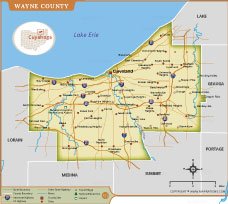
The Cuyahoga County Map provides a detailed view of one of Ohio’s most populous counties, located along the southern shore of Lake Erie. The map highlights major cities and communities including Cleveland, Parma, Lakewood, Euclid, Strongsville, and Solon. Key transportation routes such as Interstates 71, 77, 80, 90, 271, and 480 are clearly marked, making it useful for travel and planning purposes. Important natural features, including the Cuyahoga River and Lake Erie shoreline, are also displayed. Cleveland Hopkins International Airport is shown for easy reference. This map helps users understand county boundaries, neighboring counties, road networks, and urban development patterns. It is ideal for education, research, business planning, and geographic reference.
Cuyahoga County Map Quick Facts
| Fact | Details |
|---|---|
| Official Name | Cuyahoga County |
| State | Ohio |
| Country | United States |
| Founded | June 7, 1807 |
| Incorporated | Organized in 1810 |
| Population | Approximately 1.24 million (2020 Census) |
| County | Cleveland |
| Area | 1,246 sq mi (3,227 km²), including water |
| Time Zone | Eastern Time Zone (ET) |
| ZIP Codes | 440xx, 441xx, 442xx ranges |
| Area Code | 216, 440 |
| Known For | Cleveland, Lake Erie shoreline, healthcare, industry, sports, and cultural institutions |
| Major Airport | Cleveland Hopkins International Airport (CLE) |
| Climate | Humid Continental Climate |
| Nickname | Heart of Northeast Ohio |
| Major Highways | I-71, I-77, I-80 (Ohio Turnpike), I-90, I-271, I-480 |
| Nearby Border | Lake County, Geauga County, Summit County, Medina County, Lorain County, and Lake Erie to the north |
| Major Attractions | Rock & Roll Hall of Fame, Cleveland Museum of Art, Cleveland Metroparks, West Side Market, Playhouse Square, Edgewater Park |
- Alabama
- Alaska
- Arizona
- Arkansas
- California
- Colorado
- Connecticut
- Delaware
- Florida
- Georgia
- Hawaii
- Idaho
- Illinois
- Indiana
- Iowa
- Kansas
- Kentucky
- Louisiana
- Maine
- Maryland
- Massachusetts
- Michigan
- Minnesota
- Mississippi
- Missouri
- Montana
- Nebraska
- Nevada
- New Hampshire
- New Jersey
- New Mexico
- New York
- North Carolina
- North Dakota
- Ohio
- Oklahoma
- Oregon
- Pennsylvania
- Rhode Island
- South Carolina
- South Dakota
- Tennessee
- Texas
- Utah
- Vermont
- Virginia
- Washington
- West Virginia
- Wisconsin
- Wyoming
- District of Columbia (Federal district)
- Afghanistan
- Albania
- Algeria
- Andorra
- Angola
- Antigua and Barbuda
- Argentina
- Armenia
- Australia
- Austria
- Azerbaijan
- Bahrain
- Bangladesh
- Barbados
- Belarus
- Belgium
- Belize
- Benin
- Bhutan
- Bolivia
- Bosnia and Herzegovina
- Botswana
- Brazil
- Brunei
- Bulgaria
- Burkina Faso
- Burma (Myanmar)
- Burundi
- Cabo Verde
- Cambodia
- Cameroon
- Canada
- Central African Republic
- Chad
- Chile
- China
- Colombia
- Comoros Islands
- Democratic Republic of the Congo
- Costa Rica
- Cote d'Ivoire
- Croatia
- Cuba
- Cyprus
- Czechia
- Denmark
- Djibouti
- Dominica
- Dominican Republic
- Ecuador
- Egypt
- El Salvador
- England
- Equatorial Guinea
- Eritrea
- Estonia
- eSwatini (formerly Swaziland)
- Ethiopia
- Federated States of Micronesia
- Fiji
- Finland
- France
- Gabon
- The Gambia
- Georgia
- Germany
- Ghana
- Greece
- Grenada
- Guatemala
- Guinea
- Guinea-Bissau
- Guyana
- Haiti
- Holy See
- Honduras
- Hungary
- Iceland
- India
- Indonesia
- Iran
- Iraq
- Ireland
- Israel
- Italy
- Jamaica
- Japan
- Jordan
- Kazakhstan
- Kenya
- Kiribati
- Kosovo
- Kuwait
- Kyrgyzstan
- Laos
- Latvia
- Lebanon
- Lesotho
- Liberia
- Libya
- Liechtenstein
- Lithuania
- Luxembourg
- Madagascar
- Malawi
- Malaysia
- Maldives
- Mali
- Malta
- Marshall Islands
- Mauritania
- Mauritius
- Mexico
- Moldova
- Monaco
- Mongolia
- Montenegro
- Morocco
- Mozambique
- Namibia
- Nauru
- Nepal
- Netherlands
- New Zealand
- Nicaragua
- Niger
- Nigeria
- North Korea
- Northern Ireland
- Norway
- Oman
- Pakistan
- Palau
- Panama
- Papua New Guinea
- Paraguay
- Peru
- Philippines
- Poland
- Portugal
- Puerto Rico (USA)
- Qatar
- North Macedonia
- Romania
- Russia
- Rwanda
- Saint Kitts and Nevis
- Saint Lucia
- Saint Vincent & the Grenadines
- Samoa
- San Marino
- Sao Tome and Principe
- Saudi Arabia
- Scotland
- Senegal
- Serbia
- Seychelles
- Sierra Leone
- Singapore
- Slovakia
- Slovenia
- Solomon Islands
- Somalia
- South Africa
- South Korea
- South Sudan
- Spain
- Sri Lanka
- Sudan
- Suriname
- Sweden
- Switzerland
- Syria
- Tajikistan
- Taiwan
- Tanzania
- Thailand
- The Bahamas
- Timor-Leste
- Togo
- Tonga
- Trinidad and Tobago
- Tunisia
- Turkey
- Turkmenistan
- Tuvalu
- Uganda
- Ukraine
- United Arab Emirates
- United Kingdom
- United States of America
- Uruguay
- Uzbekistan
- Vanuatu
- Western Sahara
- Venezuela
- Vietnam
- Wales
- Yemen
- Zambia
- Zimbabwe