Providence County Map
About Providence County Map
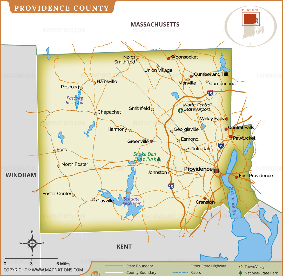
This Providence County map provides a detailed view of the most populous county in Rhode Island. It highlights major cities including Providence, Pawtucket, Central Falls, Woonsocket, Cranston, and East Providence, along with smaller towns and villages. The map clearly marks Interstate 95, Interstate 295, state highways, rivers, reservoirs, Snake Den State Park, and North Central State Airport for easy navigation. County and state boundaries are shown, making it an excellent reference for travelers, students, researchers, and educators. Whether you are planning a trip, studying local geography, or looking for a high-quality printable map, this detailed Providence County map offers accurate geographic information and a clear layout suitable for personal, educational, and business use.
Providence County Map Quick Facts
| Fact | Details |
|---|---|
| Official Name | Providence County |
| State | Rhode Island |
| Country | United States |
| Founded | June 22, 1703 |
| Incorporated | Providence County operates as a county of Rhode Island; county government functions were abolished in 1846, though the county remains a geographic and judicial division. |
| Population | Approximately 661,000 (2024 estimate) |
| County | Providence |
| Area | 436 sq mi (1,129 km²) – Land: 410 sq mi (1,062 km²); Water: 26 sq mi (67 km²) |
| Time Zone | Eastern Time Zone (ET) – UTC-5 (EST), UTC-4 (EDT) |
| ZIP Codes | 02814, 02824, 02825, 02826, 02828, 02829, 02830, 02831, 02838, 02839, 02857, 02858, 02859, 02860, 02861, 02863, 02864, 02865, 02895, 02896, 02903–02921 |
| Area Code | 401 |
| Known For | Rhode Island's largest county, Brown University, Providence city, WaterFire festival, historic architecture, manufacturing heritage, arts and education |
| Major Airport | Rhode Island T. F. Green International Airport (PVD), Warwick (serving the county); North Central State Airport (Smithfield) |
| Climate | Humid Continental Climate with warm summers, cold winters, and year-round precipitation |
| Nickname | Home of Rhode Island's Capital County |
| Major Highways | Interstate 95 (I-95), Interstate 295 (I-295), U.S. Route 6, U.S. Route 44, RI Route 146, RI Route 7 |
| Nearby Border | Massachusetts (north), Windham County, Connecticut (west), Kent County (south), Bristol County and Newport County (southeast) |
| Major Attractions | WaterFire Providence, Roger Williams Park Zoo, Brown University, Rhode Island State House, Slater Mill Historic Site, Blackstone River Valley, Snake Den State Park, Providence Performing Arts Center, Federal Hill, Twin River Casino |
- Alabama
- Alaska
- Arizona
- Arkansas
- California
- Colorado
- Connecticut
- Delaware
- Florida
- Georgia
- Hawaii
- Idaho
- Illinois
- Indiana
- Iowa
- Kansas
- Kentucky
- Louisiana
- Maine
- Maryland
- Massachusetts
- Michigan
- Minnesota
- Mississippi
- Missouri
- Montana
- Nebraska
- Nevada
- New Hampshire
- New Jersey
- New Mexico
- New York
- North Carolina
- North Dakota
- Ohio
- Oklahoma
- Oregon
- Pennsylvania
- Rhode Island
- South Carolina
- South Dakota
- Tennessee
- Texas
- Utah
- Vermont
- Virginia
- Washington
- West Virginia
- Wisconsin
- Wyoming
- District of Columbia (Federal district)
- Afghanistan
- Albania
- Algeria
- Andorra
- Angola
- Antigua and Barbuda
- Argentina
- Armenia
- Australia
- Austria
- Azerbaijan
- Bahrain
- Bangladesh
- Barbados
- Belarus
- Belgium
- Belize
- Benin
- Bhutan
- Bolivia
- Bosnia and Herzegovina
- Botswana
- Brazil
- Brunei
- Bulgaria
- Burkina Faso
- Burma (Myanmar)
- Burundi
- Cabo Verde
- Cambodia
- Cameroon
- Canada
- Central African Republic
- Chad
- Chile
- China
- Colombia
- Comoros Islands
- Democratic Republic of the Congo
- Costa Rica
- Cote d'Ivoire
- Croatia
- Cuba
- Cyprus
- Czechia
- Denmark
- Djibouti
- Dominica
- Dominican Republic
- Ecuador
- Egypt
- El Salvador
- England
- Equatorial Guinea
- Eritrea
- Estonia
- eSwatini (formerly Swaziland)
- Ethiopia
- Federated States of Micronesia
- Fiji
- Finland
- France
- Gabon
- The Gambia
- Georgia
- Germany
- Ghana
- Greece
- Grenada
- Guatemala
- Guinea
- Guinea-Bissau
- Guyana
- Haiti
- Holy See
- Honduras
- Hungary
- Iceland
- India
- Indonesia
- Iran
- Iraq
- Ireland
- Israel
- Italy
- Jamaica
- Japan
- Jordan
- Kazakhstan
- Kenya
- Kiribati
- Kosovo
- Kuwait
- Kyrgyzstan
- Laos
- Latvia
- Lebanon
- Lesotho
- Liberia
- Libya
- Liechtenstein
- Lithuania
- Luxembourg
- Madagascar
- Malawi
- Malaysia
- Maldives
- Mali
- Malta
- Marshall Islands
- Mauritania
- Mauritius
- Mexico
- Moldova
- Monaco
- Mongolia
- Montenegro
- Morocco
- Mozambique
- Namibia
- Nauru
- Nepal
- Netherlands
- New Zealand
- Nicaragua
- Niger
- Nigeria
- North Korea
- Northern Ireland
- Norway
- Oman
- Pakistan
- Palau
- Panama
- Papua New Guinea
- Paraguay
- Peru
- Philippines
- Poland
- Portugal
- Puerto Rico (USA)
- Qatar
- North Macedonia
- Romania
- Russia
- Rwanda
- Saint Kitts and Nevis
- Saint Lucia
- Saint Vincent & the Grenadines
- Samoa
- San Marino
- Sao Tome and Principe
- Saudi Arabia
- Scotland
- Senegal
- Serbia
- Seychelles
- Sierra Leone
- Singapore
- Slovakia
- Slovenia
- Solomon Islands
- Somalia
- South Africa
- South Korea
- South Sudan
- Spain
- Sri Lanka
- Sudan
- Suriname
- Sweden
- Switzerland
- Syria
- Tajikistan
- Taiwan
- Tanzania
- Thailand
- The Bahamas
- Timor-Leste
- Togo
- Tonga
- Trinidad and Tobago
- Tunisia
- Turkey
- Turkmenistan
- Tuvalu
- Uganda
- Ukraine
- United Arab Emirates
- United Kingdom
- United States of America
- Uruguay
- Uzbekistan
- Vanuatu
- Western Sahara
- Venezuela
- Vietnam
- Wales
- Yemen
- Zambia
- Zimbabwe