TRAVIS COUNTY MAP





About Travis County Map
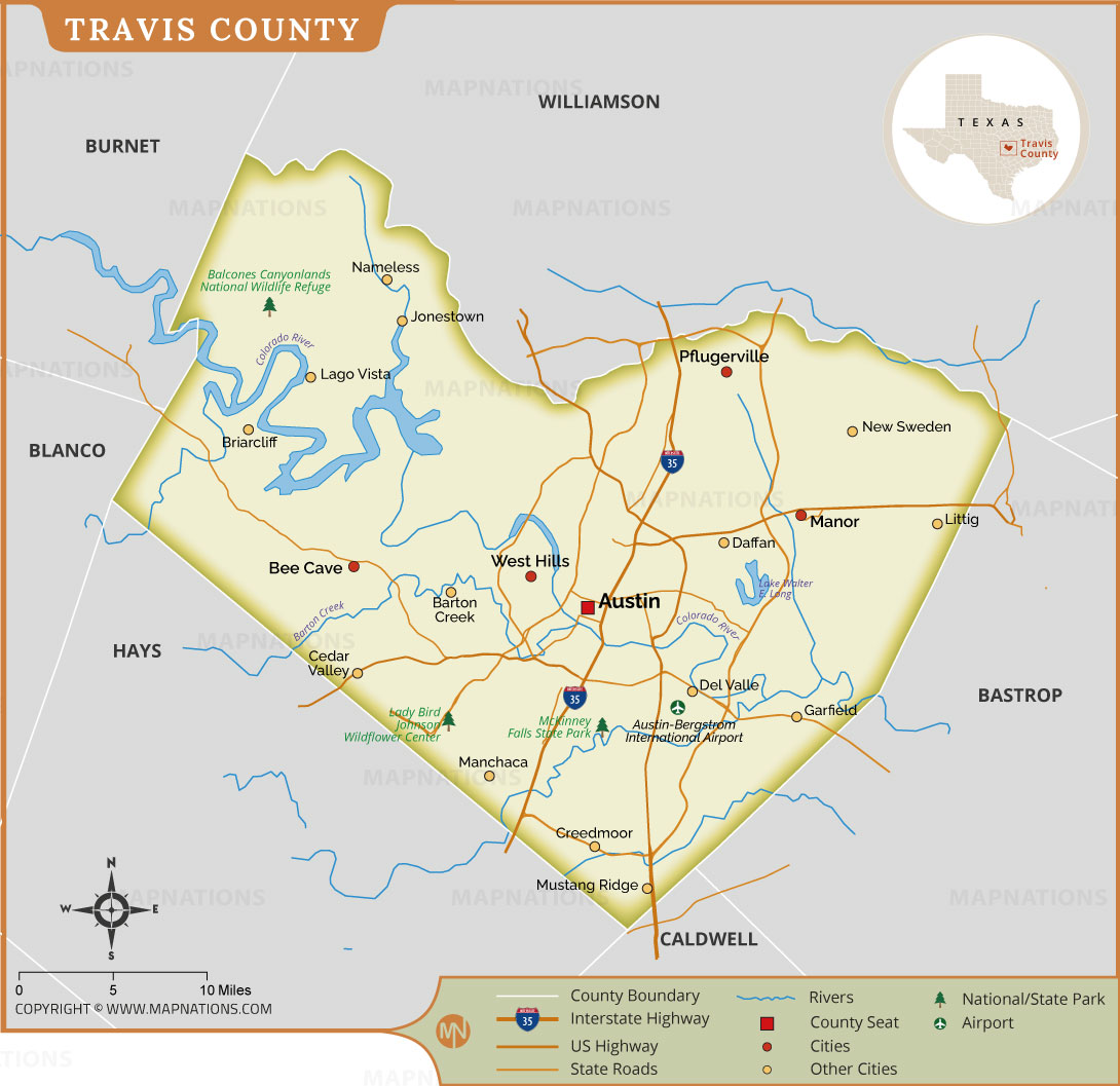
This detailed Travis County map shows the location, boundaries, cities, transportation routes, waterways, and major landmarks of Travis County, Texas. Austin, the county seat and state capital, is prominently shown near the center of the map. Other communities include Pflugerville, Manor, Lago Vista, Lakeway, Bee Cave, Cedar Valley, Manchaca, Creedmoor, and Mustang Ridge. Major transportation routes, including Interstate 35 and important U.S. and state highways, are displayed for easy reference. The map also identifies the Colorado River, Lake Travis, Lady Bird Johnson Wildflower Center, Balcones Canyonlands National Wildlife Refuge, Austin-Bergstrom International Airport, and several parks and recreational areas. Neighboring counties, including Williamson, Burnet, Blanco, Hays, Bastrop, and Caldwell, are shown around Travis County. This map is useful for students, travelers, researchers, businesses, and anyone interested in the geography of Central Texas.
Travis County Map Quick Facts
| Fact | Details |
|---|---|
| Official Name | Travis County, Texas |
| State | Texas |
| Country | United States |
| Founded | 1840 |
| Incorporated | Organized in 1843 |
| Population | 1,389,670 (2025 estimate) |
| County | Austin |
| Area | 994.05 sq mi land area; approximately 1,025 sq mi total county area |
| Time Zone | Central Time Zone (CT) |
| ZIP Codes | Primarily 786xx, 787xx, and 733xx ranges |
| Area Code | 512 and 737 |
| Known For | Austin, Texas State Capitol, live music, technology, SXSW and outdoor recreation |
| Major Airport | Austin-Bergstrom International Airport (AUS) |
| Climate | Humid subtropical; hot summers and relatively mild winters |
| Nickname | No widely established official county nickname |
| Major Highways | I-35, US 183, US 290, SH 71, SH 130, SH 45, Loop 1 (MoPac) |
| Nearby Border | Williamson, Burnet, Blanco, Hays, Caldwell and Bastrop |
| Major Attractions | Barton Springs Pool, Hamilton Pool Preserve, Lady Bird Johnson Wildflower Center, SXSW, Austin's entertainment districts and Lake Travis |

- Alabama
- Alaska
- Arizona
- Arkansas
- California
- Colorado
- Connecticut
- Delaware
- Florida
- Georgia
- Hawaii
- Idaho
- Illinois
- Indiana
- Iowa
- Kansas
- Kentucky
- Louisiana
- Maine
- Maryland
- Massachusetts
- Michigan
- Minnesota
- Mississippi
- Missouri
- Montana
- Nebraska
- Nevada
- New Hampshire
- New Jersey
- New Mexico
- New York
- North Carolina
- North Dakota
- Ohio
- Oklahoma
- Oregon
- Pennsylvania
- Rhode Island
- South Carolina
- South Dakota
- Tennessee
- Texas
- Utah
- Vermont
- Virginia
- Washington
- West Virginia
- Wisconsin
- Wyoming
- District of Columbia (Federal district)
- Afghanistan
- Albania
- Algeria
- Andorra
- Angola
- Antigua and Barbuda
- Argentina
- Armenia
- Australia
- Austria
- Azerbaijan
- Bahrain
- Bangladesh
- Barbados
- Belarus
- Belgium
- Belize
- Benin
- Bhutan
- Bolivia
- Bosnia and Herzegovina
- Botswana
- Brazil
- Brunei
- Bulgaria
- Burkina Faso
- Burma (Myanmar)
- Burundi
- Cabo Verde
- Cambodia
- Cameroon
- Canada
- Central African Republic
- Chad
- Chile
- China
- Colombia
- Comoros Islands
- Democratic Republic of the Congo
- Costa Rica
- Cote d'Ivoire
- Croatia
- Cuba
- Cyprus
- Czechia
- Denmark
- Djibouti
- Dominica
- Dominican Republic
- Ecuador
- Egypt
- El Salvador
- England
- Equatorial Guinea
- Eritrea
- Estonia
- eSwatini (formerly Swaziland)
- Ethiopia
- Federated States of Micronesia
- Fiji
- Finland
- France
- Gabon
- The Gambia
- Georgia
- Germany
- Ghana
- Greece
- Grenada
- Guatemala
- Guinea
- Guinea-Bissau
- Guyana
- Haiti
- Holy See
- Honduras
- Hungary
- Iceland
- India
- Indonesia
- Iran
- Iraq
- Ireland
- Israel
- Italy
- Jamaica
- Japan
- Jordan
- Kazakhstan
- Kenya
- Kiribati
- Kosovo
- Kuwait
- Kyrgyzstan
- Laos
- Latvia
- Lebanon
- Lesotho
- Liberia
- Libya
- Liechtenstein
- Lithuania
- Luxembourg
- Madagascar
- Malawi
- Malaysia
- Maldives
- Mali
- Malta
- Marshall Islands
- Mauritania
- Mauritius
- Mexico
- Moldova
- Monaco
- Mongolia
- Montenegro
- Morocco
- Mozambique
- Namibia
- Nauru
- Nepal
- Netherlands
- New Zealand
- Nicaragua
- Niger
- Nigeria
- North Korea
- Northern Ireland
- Norway
- Oman
- Pakistan
- Palau
- Panama
- Papua New Guinea
- Paraguay
- Peru
- Philippines
- Poland
- Portugal
- Puerto Rico (USA)
- Qatar
- North Macedonia
- Romania
- Russia
- Rwanda
- Saint Kitts and Nevis
- Saint Lucia
- Saint Vincent & the Grenadines
- Samoa
- San Marino
- Sao Tome and Principe
- Saudi Arabia
- Scotland
- Senegal
- Serbia
- Seychelles
- Sierra Leone
- Singapore
- Slovakia
- Slovenia
- Solomon Islands
- Somalia
- South Africa
- South Korea
- South Sudan
- Spain
- Sri Lanka
- Sudan
- Suriname
- Sweden
- Switzerland
- Syria
- Tajikistan
- Taiwan
- Tanzania
- Thailand
- The Bahamas
- Timor-Leste
- Togo
- Tonga
- Trinidad and Tobago
- Tunisia
- Turkey
- Turkmenistan
- Tuvalu
- Uganda
- Ukraine
- United Arab Emirates
- United Kingdom
- United States of America
- Uruguay
- Uzbekistan
- Vanuatu
- Western Sahara
- Venezuela
- Vietnam
- Wales
- Yemen
- Zambia
- Zimbabwe