India River Map

About India River Map
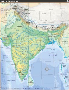
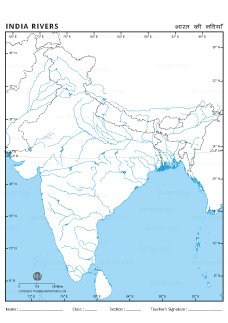
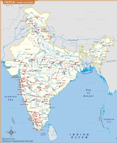
India is blessed with an extensive network of rivers that shape its geography, sustain its ecosystems, and support millions of lives. This map showcases the country's major river systems, their tributaries, and their flow across diverse terrains.
Himalayan Rivers:
- The Ganga River System, the lifeline of northern India, is fed by tributaries like Yamuna, Ghaghara, Gandak, and Kosi. It originates from the Gangotri Glacier and flows into the Bay of Bengal.
- The Brahmaputra River, originating in Tibet, flows through Arunachal Pradesh and Assam, merging with the Ganga in Bangladesh.
- The Indus River System, which flows mainly through Pakistan, includes tributaries like Jhelum, Chenab, Ravi, Beas, and Sutlej.
Peninsular Rivers:
- The Godavari, known as the Dakshin Ganga, is India's second-longest river and flows through Maharashtra, Telangana, and Andhra Pradesh.
- The Krishna River passes through Karnataka, Maharashtra, and Andhra Pradesh, while the Kaveri sustains Tamil Nadu and Karnataka.
- West-flowing rivers like Narmada and Tapi drain into the Arabian Sea.
Other Rivers:
- The Mahanadi, Chambal, and Subarnarekha play a crucial role in eastern and central India. Coastal rivers like the Mandovi and Periyar are vital for the western and southern coasts.
The map illustrates India's rivers with precision, showcasing their origins, courses, and endpoints. It provides a clear understanding of how rivers influence agriculture, hydropower, and biodiversity. This detailed representation is an invaluable tool for understanding India's water resources and their critical role in the nation's development.


INDIA MAPS


WORLD COUNTRIES
- Afghanistan
- Albania
- Algeria
- Andorra
- Angola
- Antigua and Barbuda
- Argentina
- Armenia
- Australia
- Austria
- Azerbaijan
- Bahrain
- Bangladesh
- Barbados
- Belarus
- Belgium
- Belize
- Benin
- Bhutan
- Bolivia
- Bosnia and Herzegovina
- Botswana
- Brazil
- Brunei
- Bulgaria
- Burkina Faso
- Burma (Myanmar)
- Burundi
- Cabo Verde
- Cambodia
- Cameroon
- Canada
- Central African Republic
- Chad
- Chile
- China
- Colombia
- Comoros Islands
- Democratic Republic of the Congo
- Costa Rica
- Cote d'Ivoire
- Croatia
- Cuba
- Cyprus
- Czechia
- Denmark
- Djibouti
- Dominica
- Dominican Republic
- Ecuador
- Egypt
- El Salvador
- England
- Equatorial Guinea
- Eritrea
- Estonia
- eSwatini (formerly Swaziland)
- Ethiopia
- Federated States of Micronesia
- Fiji
- Finland
- France
- Gabon
- The Gambia
- Georgia
- Germany
- Ghana
- Greece
- Grenada
- Guatemala
- Guinea
- Guinea-Bissau
- Guyana
- Haiti
- Holy See
- Honduras
- Hungary
- Iceland
- India
- Indonesia
- Iran
- Iraq
- Ireland
- Israel
- Italy
- Jamaica
- Japan
- Jordan
- Kazakhstan
- Kenya
- Kiribati
- Kosovo
- Kuwait
- Kyrgyzstan
- Laos
- Latvia
- Lebanon
- Lesotho
- Liberia
- Libya
- Liechtenstein
- Lithuania
- Luxembourg
- Madagascar
- Malawi
- Malaysia
- Maldives
- Mali
- Malta
- Marshall Islands
- Mauritania
- Mauritius
- Mexico
- Moldova
- Monaco
- Mongolia
- Montenegro
- Morocco
- Mozambique
- Namibia
- Nauru
- Nepal
- Netherlands
- New Zealand
- Nicaragua
- Niger
- Nigeria
- North Korea
- Northern Ireland
- Norway
- Oman
- Pakistan
- Palau
- Panama
- Papua New Guinea
- Paraguay
- Peru
- Philippines
- Poland
- Portugal
- Puerto Rico (USA)
- Qatar
- North Macedonia
- Romania
- Russia
- Rwanda
- Saint Kitts and Nevis
- Saint Lucia
- Saint Vincent & the Grenadines
- Samoa
- San Marino
- Sao Tome and Principe
- Saudi Arabia
- Scotland
- Senegal
- Serbia
- Seychelles
- Sierra Leone
- Singapore
- Slovakia
- Slovenia
- Solomon Islands
- Somalia
- South Africa
- South Korea
- South Sudan
- Spain
- Sri Lanka
- Sudan
- Suriname
- Sweden
- Switzerland
- Syria
- Tajikistan
- Taiwan
- Tanzania
- Thailand
- The Bahamas
- Timor-Leste
- Togo
- Tonga
- Trinidad and Tobago
- Tunisia
- Turkey
- Turkmenistan
- Tuvalu
- Uganda
- Ukraine
- United Arab Emirates
- United Kingdom
- United States of America
- Uruguay
- Uzbekistan
- Vanuatu
- Western Sahara
- Venezuela
- Vietnam
- Wales
- Yemen
- Zambia
- Zimbabwe
