Tamil Nadu District Map

About Tamil Nadu District Map
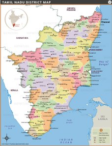
This colorful and informative map of Tamil Nadu shows all of its districts with clear boundaries and labels. Each district is colored differently, making it easy to distinguish between regions such as Chennai, Coimbatore, Madurai and Tirunelveli. Major cities and towns are marked, with Chennai prominently featured as the state capital. The map also shows neighboring states—Kerala, Karnataka and Andhra Pradesh—as well as the Union Territory of Puducherry. Nearby water bodies such as the Bay of Bengal, the Indian Ocean and the Palk Strait are labeled, as well as Sri Lanka to the south.
List of Districts in Tamil Nadu
| District | Headquarters | Area(km.²) | Population | Ariyalur | Ariyalur | 1939 | 754894 | Chennai | Chennai | 174 | 4646732 | Coimbatore | Coimbatore | 7469 | 3458045 | Cuddalore | Cuddalore | 3999 | 2605914 | Dharmapuri | Dharmapuri | 9622 | 1506843 | Dindigul | Dindigul | 6058 | 2159775 | Erode | Erode | 8209 | 2251744 | Kancheepuram | Kancheepuram | 4433 | 3998252 | Kanyakumari | Nagercoil | 1685 | 1870374 | Karur | Karur | 2896 | 1064493 | Krishnagiri | Dharmapuri | 9622 | 1879809 | Madurai | Madurai | 3676 | 3038252 | Nagapattinam | Nagapattinam | 2716 | 1616450 | Namakkal | Namakkal | 3429 | 1726601 | Nilgiris | Udhagamandalam | 2549 | 735394 | Perambalur | Perambalur | 1752 | 565223 | Pudukkottai | Pudukkottai | 4651 | 1618345 | Ramanathapuram | Ramanathapuram | 4123 | 1353445 | Salem | Salem | 5220 | 3482056 | Sivaganga | Sivaganga | 4086 | 1339101 | Thanjavur | Thanjavur | 3397 | 2405890 | Theni | Theni | 3066 | 1245899 | Thiruvallur | Thiruvallur | 3424 | 3728104 | Thiruvarur | Thiruvarur | 2161 | 1264277 | Thoothukudi | Thoothukudi | 4621 | 1750176 | Tiruchirappalli | Tiruchirappalli | 4407 | 2722290 | Tirunelveli | Tirunelveli | 6810 | 3077233 | Tiruppur | Tirupur | 5106 | 2479052 | Tiruvannamalai | Tiruvannamalai | 6191 | 2464875 | Vellore | Vellore | 6077 | 3936331 | Villupuram | Villupuram | 7217 | 3458873 | Virudhunagar | Virudhunagar | 4288 | 1942288 |
|---|


TAMIL NADU MAPS


INDIA STATE MAPS


WORLD COUNTRIES
- Afghanistan
- Albania
- Algeria
- Andorra
- Angola
- Antigua and Barbuda
- Argentina
- Armenia
- Australia
- Austria
- Azerbaijan
- Bahrain
- Bangladesh
- Barbados
- Belarus
- Belgium
- Belize
- Benin
- Bhutan
- Bolivia
- Bosnia and Herzegovina
- Botswana
- Brazil
- Brunei
- Bulgaria
- Burkina Faso
- Burma (Myanmar)
- Burundi
- Cabo Verde
- Cambodia
- Cameroon
- Canada
- Central African Republic
- Chad
- Chile
- China
- Colombia
- Comoros Islands
- Democratic Republic of the Congo
- Costa Rica
- Cote d'Ivoire
- Croatia
- Cuba
- Cyprus
- Czechia
- Denmark
- Djibouti
- Dominica
- Dominican Republic
- Ecuador
- Egypt
- El Salvador
- England
- Equatorial Guinea
- Eritrea
- Estonia
- eSwatini (formerly Swaziland)
- Ethiopia
- Federated States of Micronesia
- Fiji
- Finland
- France
- Gabon
- The Gambia
- Georgia
- Germany
- Ghana
- Greece
- Grenada
- Guatemala
- Guinea
- Guinea-Bissau
- Guyana
- Haiti
- Holy See
- Honduras
- Hungary
- Iceland
- India
- Indonesia
- Iran
- Iraq
- Ireland
- Israel
- Italy
- Jamaica
- Japan
- Jordan
- Kazakhstan
- Kenya
- Kiribati
- Kosovo
- Kuwait
- Kyrgyzstan
- Laos
- Latvia
- Lebanon
- Lesotho
- Liberia
- Libya
- Liechtenstein
- Lithuania
- Luxembourg
- Madagascar
- Malawi
- Malaysia
- Maldives
- Mali
- Malta
- Marshall Islands
- Mauritania
- Mauritius
- Mexico
- Moldova
- Monaco
- Mongolia
- Montenegro
- Morocco
- Mozambique
- Namibia
- Nauru
- Nepal
- Netherlands
- New Zealand
- Nicaragua
- Niger
- Nigeria
- North Korea
- Northern Ireland
- Norway
- Oman
- Pakistan
- Palau
- Panama
- Papua New Guinea
- Paraguay
- Peru
- Philippines
- Poland
- Portugal
- Puerto Rico (USA)
- Qatar
- North Macedonia
- Romania
- Russia
- Rwanda
- Saint Kitts and Nevis
- Saint Lucia
- Saint Vincent & the Grenadines
- Samoa
- San Marino
- Sao Tome and Principe
- Saudi Arabia
- Scotland
- Senegal
- Serbia
- Seychelles
- Sierra Leone
- Singapore
- Slovakia
- Slovenia
- Solomon Islands
- Somalia
- South Africa
- South Korea
- South Sudan
- Spain
- Sri Lanka
- Sudan
- Suriname
- Sweden
- Switzerland
- Syria
- Tajikistan
- Taiwan
- Tanzania
- Thailand
- The Bahamas
- Timor-Leste
- Togo
- Tonga
- Trinidad and Tobago
- Tunisia
- Turkey
- Turkmenistan
- Tuvalu
- Uganda
- Ukraine
- United Arab Emirates
- United Kingdom
- United States of America
- Uruguay
- Uzbekistan
- Vanuatu
- Western Sahara
- Venezuela
- Vietnam
- Wales
- Yemen
- Zambia
- Zimbabwe
