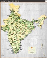
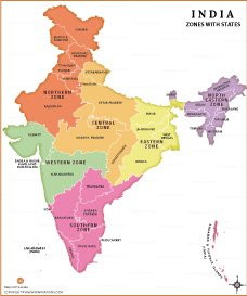
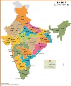
India Railway Zones Map

About India Railway Zones Map
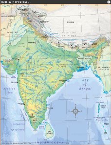
The India Railway Zones Map provides a detailed overview of the administrative structure of Indian Railways, one of the world's largest rail networks. This map highlights all major railway zones, including Northern Railway (NR), Western Railway (WR), Central Railway (CR), Southern Railway (SR), Eastern Railway (ER), East Central Railway (ECR), South Eastern Railway (SER), East Coast Railway (ECoR), South Central Railway (SCR), South Coast Railway (SCoR), North Eastern Railway (NER), Northeast Frontier Railway (NFR), North Central Railway (NCR), West Central Railway (WCR), South East Central Railway (SECR), South Western Railway (SWR), North Western Railway (NWR), and Konkan Railway (KR). The map also marks zonal headquarters, divisional headquarters, railway lines, and zone boundaries, making it a valuable resource for researchers, students, railway enthusiasts, and travelers. It helps users understand the geographical distribution and operational management of India's extensive railway network across different regions of the country.
Indian Railways is divided into 18 railway zones to efficiently manage train operations, infrastructure maintenance, passenger services, and freight transportation across the country. Each zone is headed by a General Manager and is further divided into railway divisions headed by Divisional Railway Managers (DRMs).
The zonal system helps Indian Railways coordinate one of the world's largest rail networks, covering more than 68,000 route kilometers and serving millions of passengers daily. The largest zones by route length include Northern Railway (NR), Western Railway (WR), and South Central Railway (SCR), while Northeast Frontier Railway (NFR) serves the strategically important northeastern states.
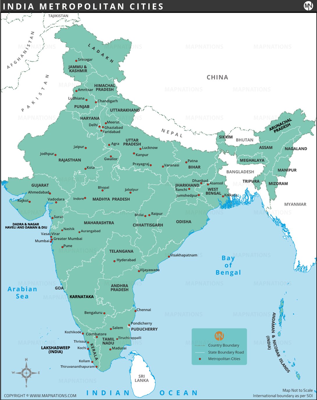
Railway zones oversee track maintenance, station management, train scheduling, safety operations, signaling systems, and revenue generation. Major zonal headquarters are located in cities such as New Delhi, Mumbai, Kolkata, Chennai, Secunderabad, Jaipur, Prayagraj, and Guwahati.
The newest railway zone is South Coast Railway (SCoR), headquartered in Visakhapatnam. Konkan Railway (KR), although not a zonal railway, operates the scenic coastal route connecting Maharashtra, Goa, and Karnataka.
India's railway zones play a vital role in connecting remote regions, supporting economic growth, facilitating tourism, and ensuring the smooth movement of passengers and freight across the nation.
Clark County Map Quick Facts
| Abbreviations | Railway Zones | Headquarters |
|---|---|---|
| CR | Central Railway | Mumbai |
| ER | Eastern Railway | Kolkata |
| ECR | East Central Railway | Hajipur |
| ECoR | East Coast Railway | Bhubaneswar |
| KR | Konkan Railway* | Navi Mumbai |
| NCR | North Central Railway | Prayagraj |
| NER | North Eastern Railway | Gorakhpur |
| NFR | Northeast Frontier Railway | Maligaon (Guwahati) |
| NR | Northern Railway | New Delhi |
| NWR | North Western Railway | Jaipur |
| SCR | South Central Railway | Secunderabad |
| SECR | South East Central Railway | Bilaspur |
| SER | South Eastern Railway | Kolkata (Garden Reach) |
| SR | Southern Railway | Chennai |
| SCoR | South Coast Railway | Visakhapatnam |
| SWR | South Western Railway | Hubballi |
| WCR | West Central Railway | Jabalpur |
| WR | Western Railway | Mumbai |


- Afghanistan
- Albania
- Algeria
- Andorra
- Angola
- Antigua and Barbuda
- Argentina
- Armenia
- Australia
- Austria
- Azerbaijan
- Bahrain
- Bangladesh
- Barbados
- Belarus
- Belgium
- Belize
- Benin
- Bhutan
- Bolivia
- Bosnia and Herzegovina
- Botswana
- Brazil
- Brunei
- Bulgaria
- Burkina Faso
- Burma (Myanmar)
- Burundi
- Cabo Verde
- Cambodia
- Cameroon
- Canada
- Central African Republic
- Chad
- Chile
- China
- Colombia
- Comoros Islands
- Democratic Republic of the Congo
- Costa Rica
- Cote d'Ivoire
- Croatia
- Cuba
- Cyprus
- Czechia
- Denmark
- Djibouti
- Dominica
- Dominican Republic
- Ecuador
- Egypt
- El Salvador
- England
- Equatorial Guinea
- Eritrea
- Estonia
- eSwatini (formerly Swaziland)
- Ethiopia
- Federated States of Micronesia
- Fiji
- Finland
- France
- Gabon
- The Gambia
- Georgia
- Germany
- Ghana
- Greece
- Grenada
- Guatemala
- Guinea
- Guinea-Bissau
- Guyana
- Haiti
- Holy See
- Honduras
- Hungary
- Iceland
- India
- Indonesia
- Iran
- Iraq
- Ireland
- Israel
- Italy
- Jamaica
- Japan
- Jordan
- Kazakhstan
- Kenya
- Kiribati
- Kosovo
- Kuwait
- Kyrgyzstan
- Laos
- Latvia
- Lebanon
- Lesotho
- Liberia
- Libya
- Liechtenstein
- Lithuania
- Luxembourg
- Madagascar
- Malawi
- Malaysia
- Maldives
- Mali
- Malta
- Marshall Islands
- Mauritania
- Mauritius
- Mexico
- Moldova
- Monaco
- Mongolia
- Montenegro
- Morocco
- Mozambique
- Namibia
- Nauru
- Nepal
- Netherlands
- New Zealand
- Nicaragua
- Niger
- Nigeria
- North Korea
- Northern Ireland
- Norway
- Oman
- Pakistan
- Palau
- Panama
- Papua New Guinea
- Paraguay
- Peru
- Philippines
- Poland
- Portugal
- Puerto Rico (USA)
- Qatar
- North Macedonia
- Romania
- Russia
- Rwanda
- Saint Kitts and Nevis
- Saint Lucia
- Saint Vincent & the Grenadines
- Samoa
- San Marino
- Sao Tome and Principe
- Saudi Arabia
- Scotland
- Senegal
- Serbia
- Seychelles
- Sierra Leone
- Singapore
- Slovakia
- Slovenia
- Solomon Islands
- Somalia
- South Africa
- South Korea
- South Sudan
- Spain
- Sri Lanka
- Sudan
- Suriname
- Sweden
- Switzerland
- Syria
- Tajikistan
- Taiwan
- Tanzania
- Thailand
- The Bahamas
- Timor-Leste
- Togo
- Tonga
- Trinidad and Tobago
- Tunisia
- Turkey
- Turkmenistan
- Tuvalu
- Uganda
- Ukraine
- United Arab Emirates
- United Kingdom
- United States of America
- Uruguay
- Uzbekistan
- Vanuatu
- Western Sahara
- Venezuela
- Vietnam
- Wales
- Yemen
- Zambia
- Zimbabwe
